
On Tuesday 25 there was the kick-off of the DiverseNile Seminar Series 2022 and our PI Julia Budka gave an inspiring opening lecture to inaugurate it. Among other topics, she mentioned the concept of agency of material culture and relevance of technologies. This led me to reflect once again in a more problematic way on the meaning of the terms materiality, identity, and style and on the use that we made of them nowadays in archaeology and, specifically, within the study of Nubian Bronze Age material culture, including our speculations on Egyptian style and Nubian style ceramic vessels.
But let’s start from the beginning, putting some basic theoretical arguments on the table!
In the last decades, the approach to materiality and the study of material culture has become a central aspect of the research and new important cognitive theories have been developed around this concept. Back in 2001 Colin Renfrew wrote “Symbol before concept: Material engagement and the early development of society” challenging the theoretical biases of cognitive archaeology and putting the bases for understanding the engagement of the mind with the material world (Renfrew 2001; see also Iliopoulos 2019, 40). In 2004, Renfrew and Malafouris developed the so-called Material Engagement Theory (MET), from which comes the notion of creative “thinging” which refers to the capacity of humans to feel/think through and about things (Malafouris 2004, 2019a). Some years later, Olsen et al. define archaeology as “the discipline of things”, that is the science of the objects, “obliged the archaeologists to be bricoleurs, who collect bits and pieces, not because of an erratic whim but because of a commitment, a fidelity to the materials we engage” (Olsen et al. 2012, 4).
All in all, MET shares with New Materialisms (see e.g., Edgeworth 2016) “a special ‘attentiveness’ to things, as well as an interest in understanding the ‘vitality’ and the ‘mattering’ of mater” (Malafouris 2019b, 9). Further, New Materialisms support “an object agency”, that is an existence of their own of the objects that transcends that of human symbolic systems. This can be seen primarily as a reaction to the symbolism of the post-processual approach (cf. Hodder 1982) and more generally as a tendency to move beyond the concepts of “meaning” and “identity” of material culture, to embrace otherwise a new ontology of materiality that sees it freed from particular forms of representations (Tsoraki et al. 2020; see also Deleuze 2007).
In other words, if for decades the philosophical thought as well as the field of social and cultural studies have been dominated by a dialectical setting of the terms “material” and “symbol” (or “meaning”) with the former in fact understood as a “signifier” or simple representative of the latter (let’s think of the dualism of Descartes, of the logic behind the linguistic structuralism or, taken to the extreme, of Magritte’s provocative sentence under his famous painting “Ceci n’est pas une pipe”), the New Materialism in archaeology, as in other fields of science, newly and provocatively suggests to shift away from an emphasis on representation and attends otherwise “to the material vibrancy of past objects and the roles that materials themselves play in the production of meaning” (Tsoraki et al. 2020, 494-495; cf. McFadyen and Hicks 2020, 3).
What does this mean in practice? How can objects exist free of the representation that man has of them? How is it possible to extrapolate from the concept of style the symbolic value acquired through the context of human thought, experience and action? What kind of speculation or ontology of matter does the New Materialism propose?
Actually, the New Materialism does turn attention away from the human agency and responsibility (cf. Ribeiro 2016; Whittle 2018), nor rejects the concept of representation per se. Rather, it aims to overcome it, exploring a more-than representational version of material meanings, and embracing a systemic (and relational) rather than dualistic vision of reality. This decentres the human subject and the mere ontology of symbolism and representation (see Tsoraki 2020, 497), considering otherwise a multiple system of relationships where things, humans, landscape, and in a broader sense whatever forms part of it (including raw materials, rocks, animals, and plants) is interconnected and linked to each other’s.
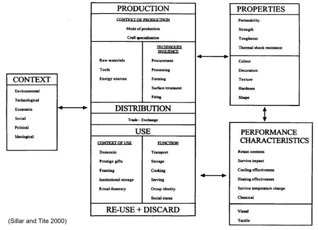
This new systemic and relational ontology expands the study of material culture further beyond the frame of the human context and its apparatus of symbolic, aesthetic, or functional meanings, embracing the much wider space of ecology. Notably, the study of things assumes a more fluid and dynamic vision, with the concept of chaîne opératoire becoming the most suitable and powerful analytical tool in order to return a vibrant analysis of past material object (e.g., lithics as ceramic assemblages) as embedded in a network of diverse and intertwined human and non-human actions. The chaîne opératoire in fact “imposes systematization in data collection, as well as the acknowledgement of a variety of elements that are invariably brought together in the conduct of technical activities” (Gosselain 2012, 246). Style, intended in its broader sense as ‘technological style’ (sensu Lechtman 1977), “potentially resides in every phase of the manufacturing sequence or chaîne opératoire” (Sillar and Tite 2000, 8).
Bringing this discussion back to the context of the Bronze Age in the Middle Nile, this premise constitutes part of the theoretical background behind the Work package 3 of our DiverseNile project, and specifically what our PI, my colleagues, and I are approaching to observe and understand through the technological analysis of ceramics, focusing on the typology, technology, material, function and contents of pottery, by combining a standard macroscopic approach with various complementary laboratory methodologies (e.g., OM, iNAA, Raman Spectroscopy, Organic Residue Analysis).
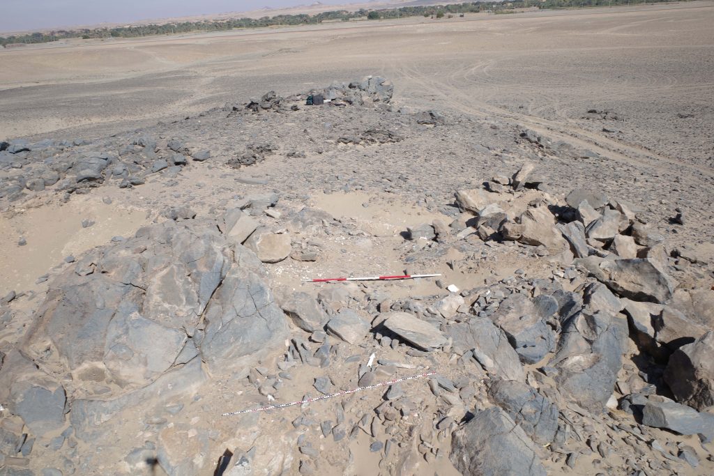
Here, we can build on results of the AcrossBorders project and our focus on the analysis of the ceramic assemblage from the New Kingdom colonial town of Sai Island and on the study of the differences between locally made wheel-made Egyptian and hand-made Nubian vessels. In the current project, we will expand our geographical scale, evaluating and comparing various ceramic reference collections from the central sites of Sai, Dukki Gel, and Amara West, with first hand material from the MUAFS concession area in the Attab to Ferka region.
What we know already now are the following main points:
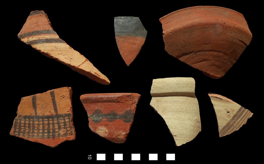
- There exist significant stylistic variations between Egyptian style and Nubian style ceramics which are reflected on several levels i.e., in the aesthetic, morphometric, and technological aspects of the ceramic production of New Kingdom Nubia;
- the ceramics manufactured locally at Sai Island, either in Egyptian and Nubian style, do not differ significantly in their chemical composition (the stage of raw material procurement), while a different chemical fingerprint has been recognized for specific imported Egyptian products (i.e., Egyptian cooking pots in Nile clay) (D’Ercole and Sterba 2018; D’Ercole and Sterba forthcoming);
- within New Kingdom Nubia, regional style in ceramics was mostly expressed by surface treatment and decoration that is within the manufacturing stages of production and finishing, while minor differences can be seen in the so-called preparation stage i.e., the formula or recipe used for making the pastes (D’Ercole forthcoming);
- about the use of vessels, some functions seem to be exclusive to Egyptian or Nubian vessels, while for others we observe overlaps even if, regardless of the generic function (e.g., cooking pots), the specific content of the vessel could vary (ORA studies hold much potential here);
- the evidence from Sai is another example for well-known so-called hybrid products, which are interesting examples of the encounter between the Egyptian and Nubian traditions.
This is in summary the state of the art of what we know from Sai Island on the stylistic and technological variations between Egyptian style and Nubian style vessels. However, there are still open questions about the system of production and use of vessels in New Kingdom Nubia as well as the relational dynamics that pass between those ceramic products, the human agents, and the past cultural and environmental landscape. The new material from the MUAFS concession area in the Attab to Ferka region is very promising in this sense and will give important insights on these topics. I cannot spoil it here, so please stay tuned on this blog 😉!
Generally speaking, is for example the definition of Egyptian and Nubian style, as we know it from Sai and other central colonial sites, applicable in the same way to the ceramic assemblages coming from the peripheral and rural contexts? How much has the cultural, environmental and ecological (also thinking in terms of raw materials, tools and energy sources) landscape influenced the choices of production, use and function of the vessels? What about the hybrid products? And does it make sense to talk, especially in rural and peripheral contexts, of a single Nubian tradition or should we consider the existence of a melting pot of Nubian influences (and eventually ceramic styles) intersected with the Egyptian one?
The questions on the table are still many that after months of remote research and theoretical debate, it is ever more urgent to return to the field to face in a tangible way the study of the material evidence. Looking much forward to it!
References:
D’Ercole, G., In prep. Petrography of the pottery from the New Kingdom town of Sai. In: J. Budka, ed. (with contributions by G. D’Ercole, J.H. Sterba and P. Ruffieux). AcrossBorders 3: Vessels for the home away from Egypt. The pottery corpus from the New Kingdom town of Sai Island. Archaeology of Egypt, Sudan and the Levant, Vienna: Austrian Academy of Sciences Press.
D’Ercole, G. and Sterba, J. H. (2018). From macro wares to micro fabrics and INAA compositional groups: the Pottery Corpus of the New Kingdom town on Sai Island (northern Sudan). In: J. Budka and J. Auenmüller, eds. From Microcosm to Macrocosm: Individual households and cities in Ancient Egypt and Nubia (pp. 171-183). Leiden: Sidestone press.
D’Ercole, G. and Sterba, J. H. In prep. Chemical analyses of the pottery corpus from the New Kingdom town of Sai. In: J. Budka, ed. (with contributions by G. D’Ercole, J.H. Sterba and P. Ruffieux). AcrossBorders 3: Vessels for the home away from Egypt. The pottery corpus from the New Kingdom town of Sai Island. Archaeology of Egypt, Sudan and the Levant, Vienna: Austrian Academy of Sciences Press.
Deleuze, G. (2007). Two Regimes of Madness, Revised Edition: Texts and Interviews 1975-1995. South Pasadena, CA: Semiotext(e).
Edgeworth, M. (2016). Grounded Objects. Archaeology and Speculative Realism. Archaeological Dialogues,23 (1), pp. 93–113.
Gosselain, O. P. (2012) Technology. In: Insoll, T. (Ed.), Oxford Handbook of the Archaeology of Ritual and Religion (pp. 243–260). Oxford: Oxford University Press.
Hodder, I. (1982). Theoretical Archaeology: A Reactionary View. In I. Hodder (Ed.), Symbolic and Structural Archaeology (pp. 1–16). Cambridge: Cambridge University Press.
Iliopoulos, A. (2019). Material Engagement Theory and its philosophical ties to pragmatism. Phenomenology and the Cognitive Sciences, 18, pp. 39–63.
Lechtman, H. (1977). Style in technology: some early thoughts. In: H. Lechtman, and T.S. Merrill (Eds.), Material culture: style, organization, and dynamics of technology (pp. 3-20). St Paul: West Publishing Company.
Malafouris, L. (2004). The cognitive basis of material engagement: Where brain, body and culture conflate. In E. DeMarrais, C. Gosden & C. Renfrew (Eds.), Rethinking materiality: The engagement of mind with the material world (pp. 53–62). Cambridge: The McDonald Institute for Archaeological Research Google Scholar.
Malafouris, L. (2019a). Thinking as “Thinging”: Psychology With Things. Current Directions in Psychological Science,29 (1), pp. 3–8.
Malafouris, L. (2019b). Mind and material engagement. Phenomenology and the Cognitive Sciences, 18, pp. 1–17.
McFadyen, L., and D. Hicks. 2020. Introduction: From Archaeography to Photology. In D. Hicks and L. McFadyen(Eds.) Archaeology and Photography: Time, Objectivity and Archive (pp. 1–20). London: Bloomsbury.
Olsen, B., Shanks, M., Webmoor, T., & Witmore, C. (2012). Archaeology: The Discipline of Things. Berkeley and Los Angeles, California: University of California Press.
Renfrew, C. (2001). Symbol before concept: Material engagement and the early development of society. In I. Hodder (Ed.), Archaeological theory today (pp. 122–140). Cambridge: Polity Press.
Renfrew, C. (2004). Towards a theory of material engagement. In E. DeMarrais, C. Gosden, & C. Renfrew (Eds.), Rethinking materiality: The engagement of mind with the material world (pp. 23–32). Cambridge: McDonald Institute for Archaeological Research.
Ribeiro, A. (2016). Against Object Agency. A Counterreaction to Sørensen’s ‘Hammers and Nails’. Archaeological Dialogues,23(2), pp. 229–235.
Sillar, B. and Tite, M.S. (2000). The Challenge of ‘Technological Choices’ for Materials Science Approaches in Archaeology. Archaeometry,42(2), pp. 2–20.
Tsoraki, C.,Barton, H., Crellin, R. J., and Harris, O. J. T. (2020). Making marks meaningful: new materialism and the microwear assemblage. World Archaeology, 52 (3), pp. 493–511.
Whittle, A. (2018). The Times of Their Lives: Hunting History in the Archaeology of Neolithic Europe. Oxford: Oxbow.
