I’ve been really busy with several commitments besides my research project, but I’d like to give you a quick update about what I’ve been up to lately. As you know, my WP2 research focuses specifically on the data collected by Vila within the region from Attab to Ferka. However, in order to have a more comprehensive idea of the significance of this data, comparison with other regions is a key aspect of my methodology. If sites such as tomb 3-P-50 at Ginis West allow us to start challenging ingrained conceptions about society and culture in New Kingdom Nubia, e.g., colonial ‘centres’ and ‘peripheries’, putting sites like this into a broader context is a really important step.
In previous posts, I stressed the importance of data sets like those produced by the ASSN or the Finish Expedition in the Batn el-Hajar area, as well as sites in the 4th cataract. But comparative research shouldn’t be limited to feeding information from different sites into a database, although it remains an important aspect of my research. A descriptive approach to data would allow us to identify previously ignored data, especially for regions that are not usually part of major narratives about Nubia, e.g., the Attab-Ferka area. However, a clear theoretical approach allows us to abstract descriptions into understandings of broader social phenomena.
Postcolonial theory has had a huge impact in archaeology, although its role in the Nile valley has not always been that explicit. Postcolonial theory provides us with a framework from which we’re able to criticise colonial narratives and practices, but also to unveil hidden, silenced logics that have remained outside mainstream historical narratives. This is highly important for the DiverseNile theoretical and methodological framework.
Egyptian-style material culture has been understood, as whole, through a generalising lens that emphasised the Egyptian presence and transposition of knowledges and practices to an acculturated Nubia. My research in the last few years allowed to unveil, from a postcolonial perspective, alternative realities created by transformed foreign objects in local contexts in New Kingdom Nubia (I explore this further in a forthcoming paper on heart scarabs, which will be published in the next issue of Sudan & Nubia). So, developing and applying a postcolonial approach to our data from the region from Attab to Ferka, combined with information from the very centres of colonial power in New Kingdom Nubia, will certainly shed more light on the substance of diversity, allowing us to include regions traditionally excluded from historical narratives into histories of alternative experiences created and sustained by alternatives roles performed by spreading material culture. That’s a bit of what I’ve been reading, thinking and writing lately. I’d be happy to think about these issues together with anyone interested!
In the last few weeks I haven’t been very present in our blog since I spent much time sitting at the microscope of the Department of Earth and Environmental Sciences of the LMU, just nearby to our office, examining and documenting the first batch of ceramic samples from the site of Dukki Gel. These samples have been included as a reference collection within our DiverseNile project thanks to the kind agreement of the excavator, Charles Bonnet, and the responsible ceramicist Philippe Ruffieux. Philippe has already studied all of these samples within their context and we can now address fresh questions within the DiverseNile work packages and with scientific analysis.
In times of the Covid pandemic, the procedure to access the laboratories is rightly strict: registration is mandatory before working in the microscopy room, only a maximum of three people are allowed to work simultaneously in the lab and of course we are required to wear medical masks and disinfect all devices and workspace at the end. All this will seem obvious, but what I personally find curious is the contrast between the meticulousness of the analytical procedure, further complicated by the current Covid rules, and the simple and tangible nature of the ancient ceramics, whose immense anthropological and material complexity, and huge archaeological interpretative potential is all enclosed in a thin section of just 30 microns thick.
In my last blog post – I introduced the method I use for the classification of the ceramic samples and the layout within the Filemaker database which I specifically designed for the purpose of the petrographic study.
So far a total of twenty-one ceramic samples from Dukki Gel has been analysed by optical microscopy (OM), while forty-three samples are currently located at the Atominstitute in Vienna where they are being analysed for instrumental Neutron Activation Analysis (iNAA) by our colleague and external expert in the project Johannes Sterba.
Most of the samples for OM (18 out of 21) are Nubian vessels among which are cooking pots (both basketry impressed and incised ware), jars, globular vessels and also fine black topped Kerma ware. Further, three Egyptian-type vessels (two red slipped bowls and one fragment of a bread mould) were analysed under the microscope.
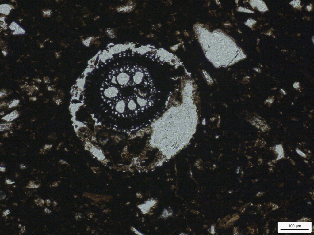
Petrographically, the Nubian samples from Dukki Gel appear quite homogeneous in term of their composition, displaying mineralogical and textural features which also resemble very much the petrography of the Nubian samples analysed from the New Kingdom town of Sai Island (see D’Ercole and Sterba 2018; D’Ercole in prep.). Differences in the textural features, in the proportion of some specific mineral phases, and in the amount and type of the organic tempers contained in the paste allowed distinguishing four principal petrographic groups or micro fabrics. The first group is characterized by a very sandy framework with a dominant grain size in the class of silt to very fine-grained sand, a good sorting of the non-plastics and very few organics mainly small and tubular in shape. The second group also displays a sandy framework, sorting is moderate with some medium sized rounded quartz and feldspar possibly added as temper, and common tubular organics partially carbonized and moderately aligned. Group 3, to which belongs the majority of the analysed samples, is sandy, moderately sorted, with common to abundant organics, either partially or completely carbonized, heterogeneous in shape and size, and possibly referring to various parts of plant remains (including stem, glume, palea, and lemma?) (Fig. 1) and also herbivore dung. Finally, the fourth group of Dukki Gel Nubian samples contains abundant heterogeneous organics similar to group 3 but also large carbonate inclusions of microcrystalline calcite most likely intentionally added as tempering material. To this last group, which does not show a real comparison with the material from Sai, where the presence of calcite was ubiquitous and seemed a natural component in the clay source/ soil rather than a tempering agent, refers exclusively cooking pots with basketry impressions and a single jar.
Figure 1 – Detail of organic inclusion with visible plant cell structure from Sample DG-17. PPL micropho by G. D’Ercole.
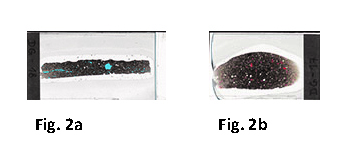
All in all, similarly to what was observed for Sai Island, the petrofacies of the Nubian ceramics is very homogeneous and points to the selection of clays, or better soils, derived from local Holocene Nile alluvia, with a composition very similar along the various sectors of the Nile river (D’Ercole and Sterba 2018). These ceramics were possibly tempered with some medium- and coarse-sized aeolian sand or with quartz grains drained by the local river systems. Technologically, the amount and type of the organic material added to the paste (more or less abundant and selected) makes the main difference and allows distinguishing among various sub-recipes or ways of doing the vessels. Further, the orientation of the voids left by the combustion of the organic matter into the paste permits to recognize among the use of different manufacturing techniques. Specifically, in the cooking pots with basketry impressions which were built on a mat, the organics appear generally well or moderately aligned with a prevalent presence of longitudinal features like stems or plant stalks (Fig. 2a). Differently, in those pots (e.g., globular pots, bowls) built with the coiling technique, the organics show mainly a poor alignment and a specific orientation that indicates the ‘relict’ coil features (Fig. 2b). The black topped and the fine polished Kerma ware generally contain less organics, these latter are also smaller in size indicating either the use of herbivore dung and/or a selection of added plant remains.
Figure 2a – Thin section scan of Sample DG-18 (Nubian cooking pot). The good alignment of the pores structures and of the voids and relicts left by the combustion of the organics indicates that this vessel was built on a mat. Image by G. D’Ercole. Figure 2b – Thin section scan of Sample DG-17 (Nubian large bowl). The specific concentric alignment of the pores structures and of the voids and relicts left by the combustion of the organics indicates that this vessel was manufactured with the coiling technique. Image by G. D’Ercole.
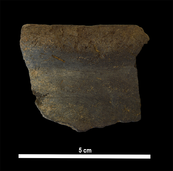
Highly interesting in the sample from Dukki Gel, is the presence of a jar with a roughly polished / wet-smoothed black surface which although showing clear Nubian technological exterior features is characterized by a coarser and sandier fabric with more abundant feldspar and granitoid rock fragments resembling certain Egyptian cooking pots (Fig. 3). This sample, so far an unicum in our selection, points to an hybridization of Nubian and Egyptian traditions (this time with the intersection of some performance of ‘Egyptian’ criteria to a general Nubian technological and stylistical formula) and well supports our overall theoretical framework and working approach on the complexity and diversity among various Nubian local narrative experiences and conceptions of material culture.
Figure 3 – Sample DG-22 (Nubian jar) withroughly polished / wet-smoothed surfaces characterized by a sandy fabric rich in alkali feldspar. Photo by G. D’Ercole.
Hopefully by the end of this month, we also will have the first set of chemical data from the reference collection from Dukki Gel in our hands which we will then compare with the macroscopic evidence and with these petrographic remarks.
References
D’Ercole, G. In prep. Petrography of the pottery from the New Kingdom town of Sai, in: J. Budka, with contributions by G. D’Ercole, J. Sterba and P. Ruffieux, AcrossBorders 3: Vessels for the home away from Egypt. The pottery corpus from the New Kingdom town of Sai Island. Archaeology of Egypt, Sudan and the Levant. Vienna.
D’Ercole, G. and Sterba, J. H. 2018. From macro wares to micro fabrics and INAA compositional groups: the Pottery Corpus of the New Kingdom town on Sai Island (northern Sudan), 171–183, in: J. Budka and J. Auenmüller (eds.), From Microcosm to Macrocosm: Individual households and cities in Ancient Egypt and Nubia. Leiden.
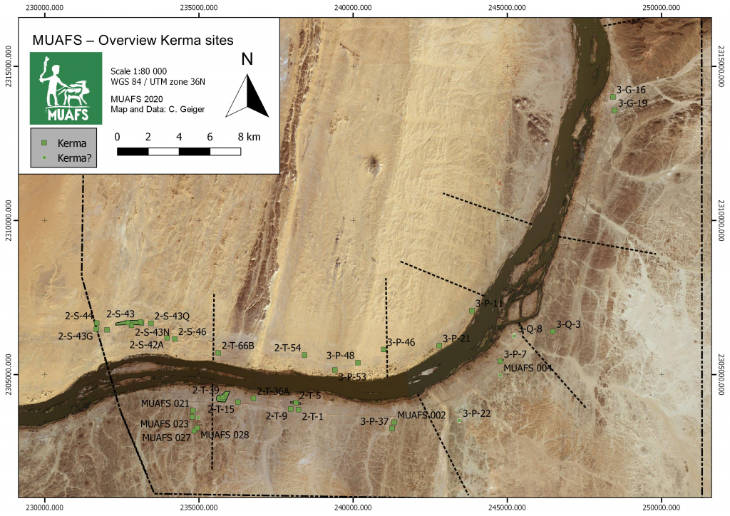
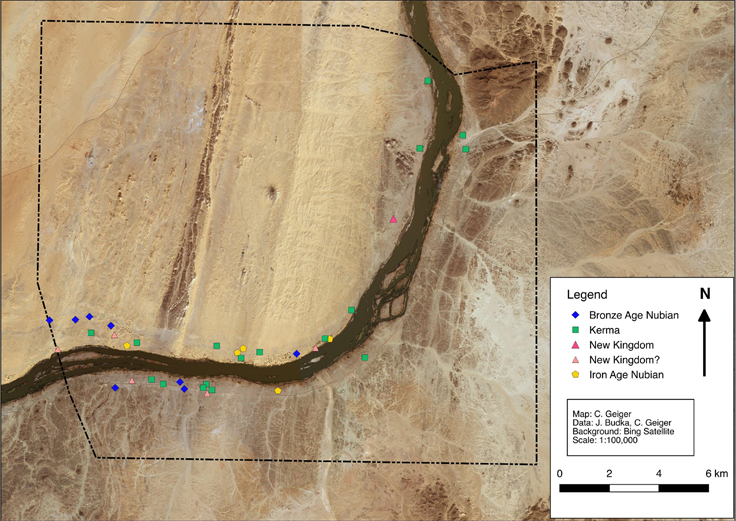
Sudan & Nubia 24 is now out and it includes a paper by PI Julia Budka on the Kerma presence at Ginis East (Budka 2020). The paper also presents an updated overview of MUAFS fieldwork, which relates to my work in the DiverseNile Project focusing on Kerma, New Kingdom and early Napatan cemeteries in the region. In the past three seasons, the MUAFS team reidentified hundreds of sites firstly described by Vila, but also identified 40 additional sites so far, including tombs which are of interest to my subproject. In my previous posts, I have focused mainly on the New Kingdom. Here I will present a brief overview of the Kerma presence, as attested by cemetery sites and isolated tombs, in Attab-Ferka (figure 1).
Figure 1: Kerma sites in the region from Attab to Ferka (status 2020). Budka 2020, fig. 13.
I have previously mentioned that, for the New Kingdom, our knowledge is mainly based on evidence from major colonial settlements and cemeteries. There are clear geographical gaps in what we know about the Egyptian colonisation of Nubia in areas such as the Batn el-Hajjar (Edwards 2020) or the MUAFS concession area. A similar situation occurs during the Kerma Period. As Julia Budka pointed out in her recent S&N paper, evidence from Attab-Ferka is extremely relevant “to address the issue of the borders of the Kerma kingdom as well as cultural manifestations of what has been labelled as ‘rural Kerma’” (Budka 2020: 63).
Veronica Hinterhuber’s last post provided an overview of her general database of sites based on information published by Vila. Her work is invaluable for my preliminary assessment of mortuary sites in our concession area. Based on her database, 10 mortuary sites first identified by Vila as dating to the Kerma Period can help us to preliminarily understand the Kerma spread in the region. Recent fieldwork has identified a large degree of destruction and plundering at those sites, which makes it important to revisit previously published and archival data with a fresh mindset to extract valuable information. Comparison with other sites, especially those at the Kerma hinterland and other ‘peripheral’ zones across Nubia, also help us shed light onto blurred spots in our datasets from Attab-Ferka.
Besides the overall plundering, Kerma tombs in the region were tumuli with granite superstructures (usually not preserved) and oval or large rectangular pits containing bone fragments, sherds and very rarely burial goods (e.g., faience beads). Kerma tombs were either larger, aprioristically isolated tombs or part of cemeteries grouping a higher number of burials; e.g., at Ferka East and Kosha East. A few skeletons were found in situ, although plundered. They were all deposited in a flexed position, sometimes on a bed; e.g. at Ferka East. Kerma tombs were reused in the Christian Period. For instance, one wrapped body dating to this period was found inside a Kerma tomb at Kitfogga, Ferka East. Sherds usually include Kerma beakers and goblets. Due to plundering, it is difficult to determine, based on the amount of information currently available, whether these burials were characterised by a simple approach to graves goods or not. Comparison with sites such as Abu Fatima, where Stuart Tyson Smith and Sarah Schrader are currently working, should allow us to gain a better picture of continuity and variation in Kerma contact spaces between, for instance, elites and non-elites or urban and rural communities.
The region from Attab to Ferka was not only a contact space within the Kerma state. It was also an area where the Kerma ‘culture’ interacted with Egyptian patterns. For example, one very interesting burial was excavated by Vila at Shagun Dukki, Ginis East, where c. 10 other tombs were detected (figure 2). It consisted of a shallow, oval pit inside of which a flexed skeleton was found (disturbed). Together with the skeleton, a bone scarab was found in the right hand, a common pattern at Classic Kerma burials at Kerma city (Minor 2012: 144). Most scarabs found at Kerma city bear similarities with scarabs from Second Intermediate Period Egypt and Syria-Palestine and would have been acquired either via trade or reuse of graves in Lower Nubia (Minor 2012: 138-140). It is difficult to read the signs on the base of the scarab from Shagun Dukki. Moreover, bone was a material used to manufacture various items in the Kerma Period, as well as among other Nubian communities, and worked as a Nubian identity marker in the New Kingdom. Were bone scarabs the result of local copying practices? Looking at the evidence from Attab-Ferka holds the potential to shed light on internal contact and variability within the Kerma realm, as well as the local roles of foreign objects in local contexts in this period.
Figure 2: A Kerma burial at Shagun Dukki, Ginis East (Vila 1977: 25).
Gratien has previously pointed out how little we know about the Kerma state outside Kerma city, as well as how the Kerma state related to other ‘Nubian’ communities north and south of the Third Cataract (Gratien 2014: 95; 1978; Bonnet 2014). Evidence from Sai (Gratien 1986) and the Fourth Cataract (Paner 2014; Herbst and Smith 2014; Wlodarska 2014; Emberling et al. 2014) can illuminate further aspects of the spread of Kerma throughout the Middle Nile. The publication of evidence from Lower Nubia is also much expected (see Edwards 2020). Recent scholarship has also been shedding light on alternative, ‘rural’ experiences of the Kerma state outside of Kerma city (Akmenkalns 2018) and comparative, ‘global’ perspectives on specific categories of artefacts across cultural borders provide interesting avenues of inquiry (Walsh 2020). In a few years, the results of the DiverseNile Project will also contribute to our understanding of a more complex and diversified landscape beyond rigid cultural divisions.
References
Akmenkalns, J. 2018. Cultural continuity and change in the wake of ancient Nubian-Egyptian interactions. PhD thesis, University of California Santa Barbara.
Bonnet, C. 2014. Forty years research on Kerma cultures. In The Fourth Cataract and beyond, eds. J. Anderson and D. Welsby, 81-94. Leuven: Peeters.
Budka, J. 2020. Kerma presence at Ginis East: The 2020 season of the Munich University Attab to Ferka Survey Project. Sudan & Nubia 24: 57-71.
Edwards, D. ed. 2020. The Archaeological Survey of Sudanese Nubia, 1963-69. Oxford: Archaeopress.
Emberling, G. et al. 2014. Peripheral vision: Identity at the margins of the early Kingdom of Kush. In The Fourth Cataract and beyond, eds. J. Anderson and D. Welsby, 329-336. Leuven: Peeters.
Gratien, B 1986. Saï I. La Nécropole Kerma. Paris: CNRS.
Gratien, B. 1978. Les cultures Kerma: essai de classification. Villeneuve-d’Ascq: Publications de l’Université de Lille III.
Gratien, B. 2014. Kerma north of the Third Cataract. In The Fourth Cataract and beyond, eds. J. Anderson and D. Welsby, 95-101. Leuven: Peeters.
Herbst, G. and S. T. Smith. 2014. Pre-Kerma transition at the Nile Fourth Cataract: First assessments of a multi-component, stratified prehistoric settlement in the UCSB/ASU Salvage Concession. In The Fourth Cataract and beyond, eds. J. Anderson and D. Welsby, 311-320. Leuven: Peeters.
Minor, E. 2012. The Use of Egyptian and Egyptianizing Material Culture in Nubian Burials of the Classic Kerma Period. PhD thesis, University of California Berkeley.
Paner, H. 2014. Kerma Culture in the Fourth Cataract of the Nile. In The Fourth Cataract and beyond, eds. J. Anderson and D. Welsby, 53-80. Leuven: Peeters.
Vila, A. 1977. La prospection archeologique de la valee du Nil au sud de la cataracte de Dal 5. Paris: CNRS.
Walsh, C. 2020. Techniques for Egyptian eyes: Diplomacy and the transmission of cosmetic practices between Egypt and Kerma. Journal of Egyptian History 13: 295-332.
Wlodarska, M. 2014. Kerma burials in the Fourth Cataract region – Three seasons of excavations at Shemkhiya. In The Fourth Cataract and beyond, eds. J. Anderson and D. Welsby, 321-328. Leuven: Peeters.
As my colleague and ‘scientific counterpart’ Rennan Lemos, responsible together with our PI for Work Package 2 (The Variability of Funerary Monuments), pointed out so perfectly in his blog entry On the footsteps of Vila and the archaeology of monumental surveys in northern Sudan, a number of different factors determine how we have to approach our engagement with the past today. Not only do we archaeologists have to keep in mind our own social or cultural conditioning, our own socialisation, which is always an on-going process, but we also have to take into account the zeitgeist of our predecessors, and thus the working methods influenced by it, when we include their previous results.
In this regard, the method that Vila and his team applied for their Archaeological Survey in the 1970ies, which also covered the MUAFS concession area from Attab to Ferka, is equally relevant for settlement sites and thus for Work Package 1 (The Variability of Domestic Architecture).
Although Vila and his team also followed up on earlier surveys in Sudan, they deliberately chose an approach that was kind of new for their time. Their main aim was to give an idea and thus evidence of the cultural legacy, to raise awareness of the archaeological value of the explored regions. Linked to that was the explicit wish to pave the way for further fieldwork in the future.
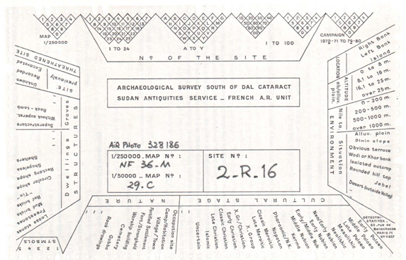
Concerning the settlements, in slight contrast to the cemeteries, where clearing or minor excavations were carried out more frequently, the major rule was that survey work must avoid disturbing the original condition of the archaeological sites. Instead of using invasive methods that would have resulted in significant destruction, (in most cases) work was limited to indicating the existence of the sites, documenting their visible remains and giving a current status report on them. The documentation system chosen by Vila and his team was based on a strict, predetermined catalogue of guidelines (Vila 1975, Volume I). Exemplarily mentioned shall be the given information about the localisation, the extent of the sites or the geographical features, and – in this point naturally somewhat more subjective – the classification of the respective archaeological value. The latter dictated quite decisively, f. ex. the extent of sampling, which was also subjected to strict rules. Another positive aspect to be highlighted is a topic usually rather neglected: The consistent application of the terms chosen for their survey (f. ex. vestiges for removable witnesses, like sherds or stone implements; remains for any kind of fixed structure) as well as the explanation of chosen terms like settlement, camp site, occupation site etc., and not least the description of the problems they were confronted with when creating their system.
Although Vila and his team likeable (and very well understandable for any field archaeologist) admitted their own hardships in this approach, having to leave to other people what they discovered, it is especially this transparency that makes it particularly helpful for us subsequent scholars to comprehend the information they gained, documented and what they understood by it.
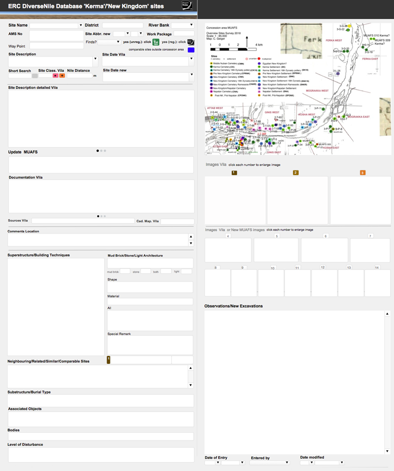
This systematics, which at that time was still applied in the field via punched cards created according to the guidelines and not unlike an analogue database (Fig. 1), enables the old survey results to be easily transferred to a now digital Database (FileMaker Pro), the ERC DiverseNile Database for ‘Kerma’ and ‘New Kingdom’ sites, I designed for Work Package 1 (see also the Petrographic Database my colleague Giulia D’Ercole designed for Work Package 3).
Figure 1. Selective card used for documentation in the 1970ies (Vila 1975: 19, Fig. 2).
This new database contains on one hand all the available documentation published by Vila concerning the settlement sites, whereas the then state of research is contrasted in a clear and critical separation with the new data gained from our own studies, which includes f. ex. not only new sites, new maps, new photographs but also a revised dating for several dates given by Vila. As strongly intertwined topics it also includes basic information on cemeteries.
This easy to handle database, which I will give you here a short overview of, can be flexibly modified and adapted to the on-going work process (Fig. 2): Structured in three parts, the database first provides a short general information about the site, f. ex. its Name and location, the AMS-No (alphanumeric classification regarding the 1, 250 000 map sheets of the Sudan Survey Department, a method firstly implemented by W.Y. Adams 1961, further elaborated by F.W. Hinkel and used by Vila), or new Way Points (taken by the MUAFS team). Important entries are of course the site’s Dating given by Vila, which has been updated if necessary (Site Date new). The second, more detailed part includes the elaborated Site description by Vila together with already published photos, drawings or sketches, again updated and compared with new results collected in our last seasons (f. ex. Observation/New Excavations). The third section serves to cover specific data relevant for the settlements within Work Package 1, such as f. ex. Superstructure or Building Techniques, as well as entries like Shape or Material.
Figure 2. Layout of the ERC DiverseNile Database for ‘Kerma’ and ‘New Kingdom’ sites (detail).
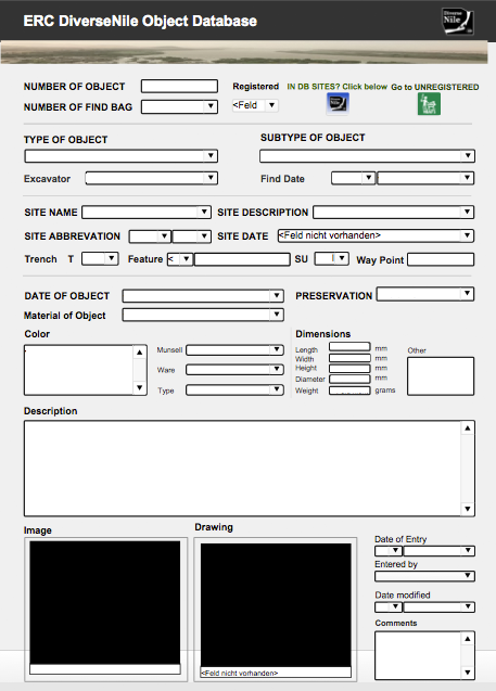
An equally beneficial option within FileMaker is the integration of other databases I made, the ERC DiverseNile Object Database (Fig. 3) and the MUAFS All Finds Database, which contain the data of all the new finds we so far recorded and are accessible through an easy command.
Figure 3. Layout of the ERC DiverseNile Object Database.
Altogether these databases are an extremely helpful and time-saving working tool to sort and select relevant data at a glance (or a click), revealing not only the wide variability of sites in our concession area but also the cultural diversity of the archaeological remains in the Attab to Ferka region, including at the moment 53 recorded sites relevant for Work Package 1.
Being able to expand and optimise these databases during the work process, they also reflect at one glance the development of past and present research: This holds f. ex. true for the attribution of sites indicated by Vila as either ‘Kerma’ or ‘Egyptian New Kingdom’, defining them then still as more rigid cultural units, than we do today. Numerous data from revisited sites and newly added ones show a much closer interconnection of cultures in this region – thus supporting our new approach to move away from these strict categories and going a step further, with our PI introducing the preliminary term Bronze Age Nubia as a starting point (Fig. 4). Provided with newer methods in archaeology and fresh promising data we are looking forward to further shedding light on this flourishing and dynamic region in the periphery of Sai and Amara West.
Figure 4. New distribution of ‘Bronze Age’ sites according to the results of the MUAFS 2018/2019 season (Budka 2019: Map 7).
References
Adams, W. Y. and Verwers C. J. 1961. ‘Archaeological Survey of Sudanese Nubia’. Kush 9, 7–43.
Budka, J. 2019 (with contributions by G. D’Ercole, C. Geiger, V. Hinterhuber and M. Scheiblecker). Towards Middle Nile Biographies: the Munich University Attab to Ferka Survey Project 2018/2019. Sudan & Nubia 23, 13–26.
Hinkel, F.W. 1977. The Archaeological Map of the Sudan. A Guide to its Use and Explanation of its Principles. Berlin.
Vila. A. 1975. La prospection archéologique de la vallée du Nil au sud de la Cataracte de Dal. Vol. 1. Paris.
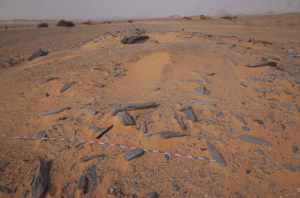
As recently outlined by Rennan Lemos, a remarkable tomb of Ramesside date was found by Vila in Ginis West. We identified this monument during our survey in 2019 and it clearly once had a tumulus superstructure; the descent to the rock-cut chambers is still visible. Some broken pottery as well as bone fragments are scattered around the superstructure, but otherwise this structure is isolated and cannot be associated with burial monuments (apart from a few Christian tombs close by).
Figure 1: Site 3-P-50 in 2019 (photo: J. Budka).
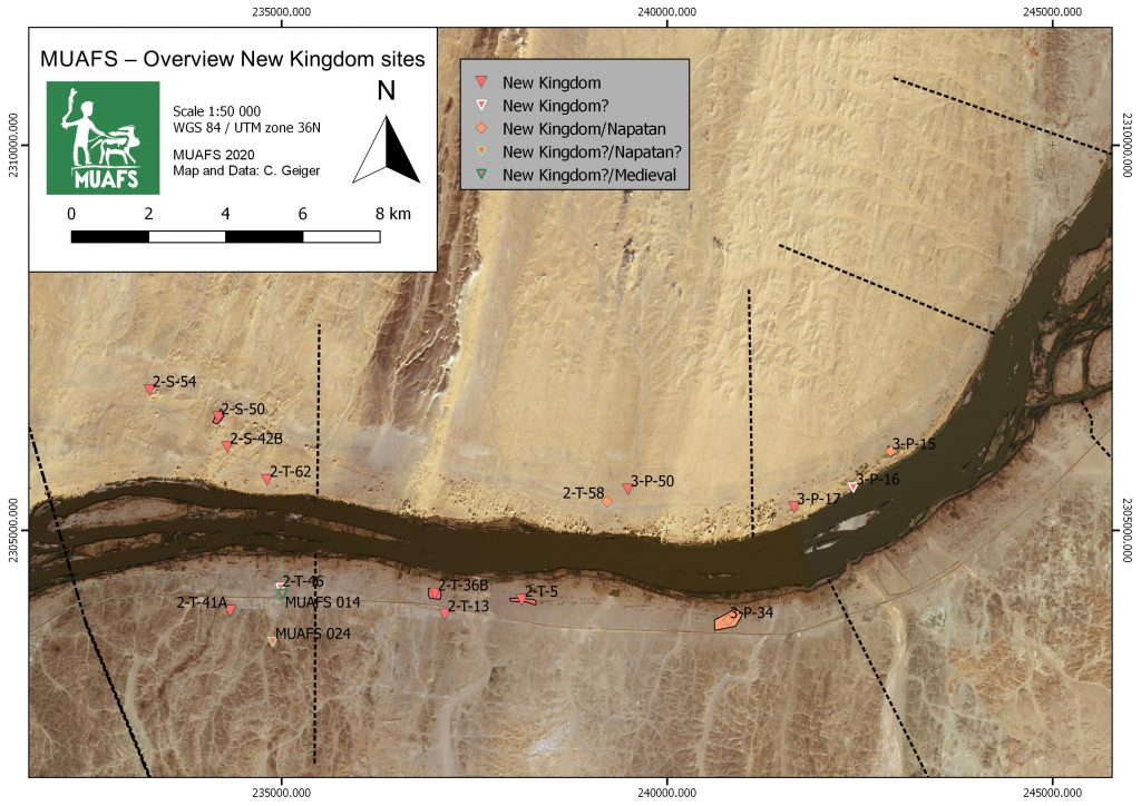
A look at the distribution map of New Kingdom sites in our MUAFS concession (see Budka 2020, 65, fig. 14) is useful for a tentative contextualisation of the tomb which, among others, yielded shabtis of the lady of the house, Isis (Vila 1977, 151). The New Kingdom sites are clustered within the southwestern part of the research area, thus close to the urban sites Amara West and Sai Island. The role of these administrative centres Amara West and Sai Island needs to be considered when looking at the ‘periphery’ (cf. Spencer 2019; see also Stevens and Garnett 2017) and might have influenced the pattern of site distribution. The latter, however, is still preliminary as I pointed out in a earlier post.
Figure 2: Distribution of New Kingdom sites in the MUAFS concession including 3-P-50, 2-T-58 and 3-P-15 (see Budka 2020, fig. 14).
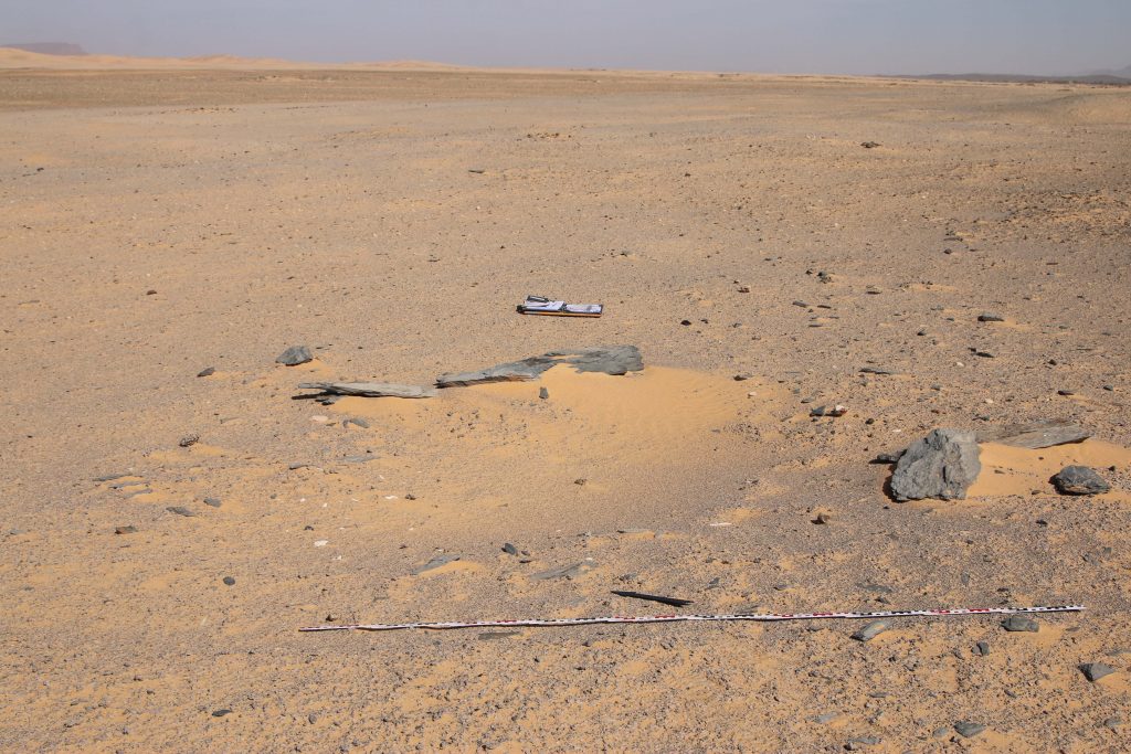
The closest possible New Kingdom site located in the neighbourhood of 3-P-50 is 2-T-58. This site is a small cemetery of several tumuli which can be attributed to the Late New Kingdom and/or the Pre-Napatan period. Unfortunately, 2-T-58 was already very much destroyed and plundered in the 1970s. There is little hope that more information than gathered by Vila can be gained from these tombs (Vila 1977, 119-122, figs. 53-54).
Figure 3: One of the looted tombs of site 2-T-58 in 2019 (photo: J. Budka).
Vila excavated one of the tombs and found the remains of four burials, of funerary beds, bodily adornment like beads and amulets and some ceramic vessels which seem to date to the late Ramesside period and the Pre-Napatan phase, finding close parallels at Amara West (Binder 2014, passim) and also at Hillat el-Arab (Vincetelli 2006, passim). A post-New Kingdom date is maybe the most likely for this excavated tumulus and its interments.
Especially interesting and most probably contemporaneous to the isolated tomb 3-P-50 is site 3-P-15 in Kosha West which is part of a cluster formed by three settlement sites (3-P-15, 3-P-16 and 3-P-17).
This habitation site on a mound of c. 55-100m shows a surface covered by schist blocks and sherds. In the northeastern part, remains of mud bricks are visible. The surface ceramics we documented show a continuation from late Ramesside times well into the ninth and maybe even the eight century BCE, thus into the Napatan era.
Figure 4: Overview of site 3-P-15 in 2019 (photo: J. Budka).
A more precise dating and a concise characterisation will require excavations – but the site seems to have been in use during the time the cemeteries at Amara West flourished and 3-P-50 was built. As already pointed out by Michaela Binder, the best parallel for 3-P-50 is tomb G244 at Amara West (Binder 2014, Binder 2017, 599-606). The latter is the largest multi-chambered tomb at Amara West with a tumulus as superstructure and, like 3-P-50, also situated in what seems to have been an isolated position during the 20th Dynasty. Maybe these tombs, their architecture, their seemingly isolated location and rich equipment (which is an intriguing mixture of Egyptian- and Nubian-style material culture) point to common aspects of local elite communities in the Amara and Ginis regions we are still far away from understanding in detail.
Our planned excavations at 3-P-15 and especially the joint efforts of Rennan Lemos focusing on the mortuary evidence and Veronica Hinterhuber on the settlement remains will hopefully allow a closer assessment of the Ramesside period in the MUAFS concession and corresponding lived experiences in the near future.
References
Binder, M. 2014. Health and Diet in Upper Nubia through Climate and Political Change. A bioarchaeological investigation of health and living conditions at ancient Amara West between 1300 and 800 BC. Unpublished PhD thesis, Durham University.
Binder, M. 2017. The New Kingdom tombs at Amara West: Funerary perspectives on Nubian-Egyptian interactions, in: N. Spencer, A. Stevens, and M. Binder (eds), Nubia in the New Kingdom. Lived experience, pharaonic control and indigenous traditions. British Museum Publications on Egypt and Sudan 3. Leuven, 591-613.
Budka, J. 2020. Kerma presence at Ginis East: the 2020 season of the Munich Universit Attab to Ferka Survey Project, Sudan and Nubia 24, 57-71.
Spencer, N. 2019. Settlements of the Second Intermediate Period and New Kingdom, in D. Raue (ed), Handbook of ancient Nubia, vol. 1. Berlin, 433-464.
Stevens, A. and A. Garnett 2017. Surveying the pharaonic desert hinterland of Amara West, in: N. Spencer, A. Stevens, and M. Binder (eds), Nubia in the New Kingdom. Lived experience, pharaonic control and indigenous traditions. British Museum Publications on Egypt and Sudan 3. Leuven, 287-306.
Vila, A. 1977. La prospection archéologique de la Vallée du Nil, au Sud de la Cataracte de Dal (Nubie Soudanaise). Fascicule 5: Le district de Ginis, Est et Ouest. Paris.
Vincentelli, I. 2006. Hillat El-Arab. The Joint Sudanese-Italian Expedition in the Napatan Region, Sudan. Sudan Archaeological Research Society Publication 15. British Archaeological Reports International Series 1570. Oxford.
Most of the available burial evidence in New Kingdom Nubia come from large cemeteries associated with temple-towns. Evidence from the hinterland of colonial towns or ‘peripheral’ areas such as the Batn al-Hajar are usually discontinuous and pose various challenges to interpretation (figure 1). Edwards recently raised discussion on the role of isolated tombs in such areas. According to him, mortuary evidence from such locations, in contrast with evidence from formal cemeteries, “should not narrow our perspectives, to the exclusion from our narratives of the vast majority of the population who were buried otherwise” (Edwards 2020: 396).
Figure 1: different physiographic zones along the Middle Nile. Wikimedia Commons.
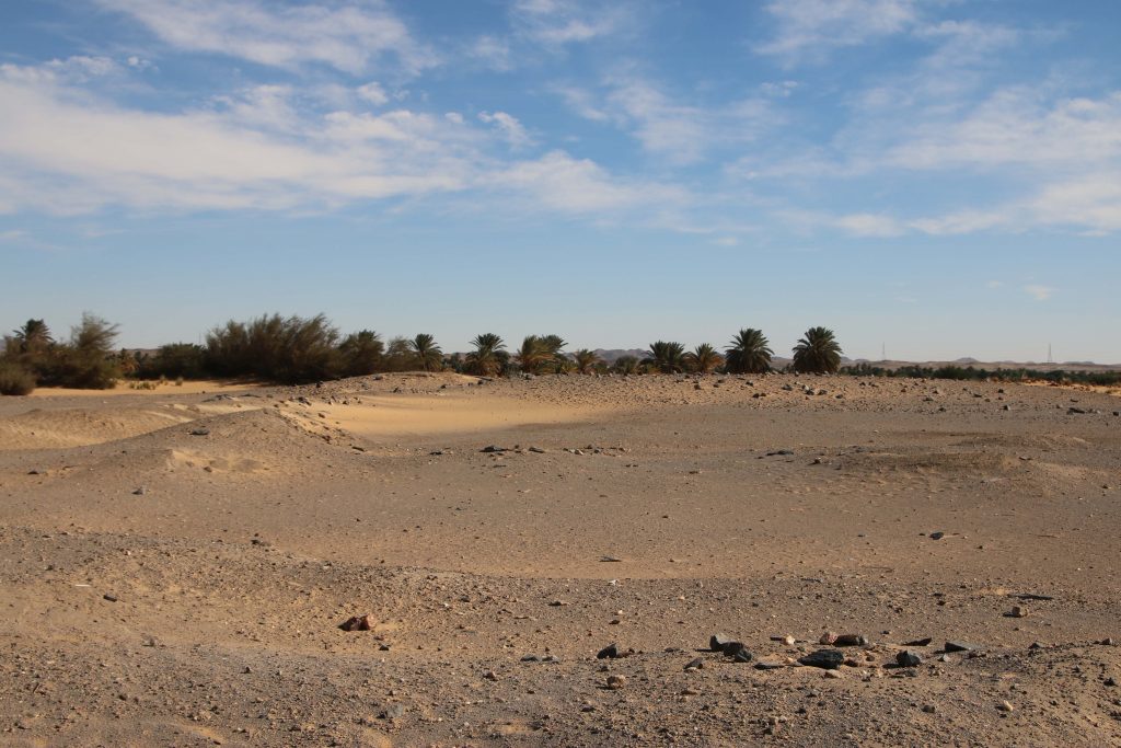
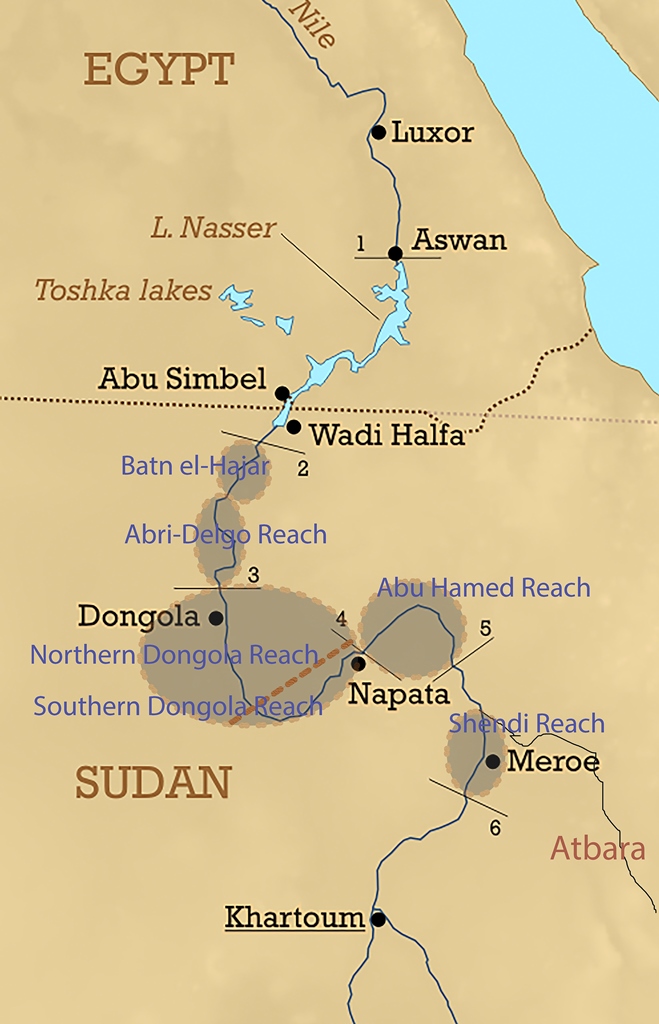
Ginis West is located north of Amara West, on the way to the Batn al-Hajar. In our concession area, evidence for formal cemeteries associated with established settlements is scarce, although continuing research and excavations will likely shed more light on this topic. In the New Kingdom, the whole area between Amara West and Lower Nubia, comprising the north Abri-Delgo Reach and the Batn el-Hajar represents a gap in our knowledge of New Kingdom Nubia. Revisiting the evidence produced by various surveys in these areas is crucial for us to develop new comparative research, especially evidence produced by the Archaeological Survey of Sudanese Nubia (ASSN, Edwards 2020), the Finnish Expedition to Sudanese Nubia (Donner 1998) and other projects working in the Batn el-Hajar; and, particularly for us working in the Attab-Ferka stretch of the Nile, Vila’s survey south of Dal cataract (Vila 1975-79).
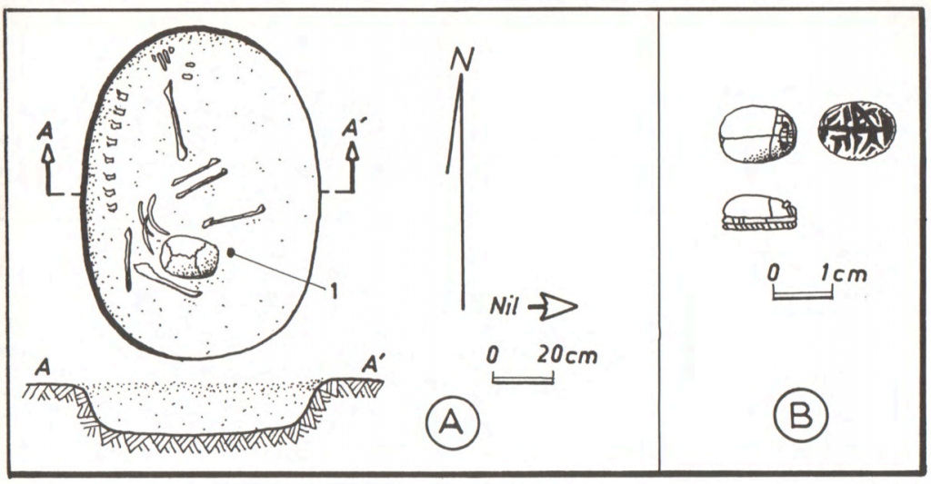
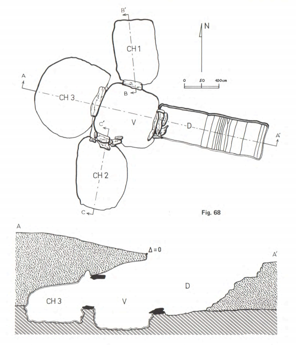
In the Batn el-Hajar, the ASSN uncovered not only simple pit graves, characteristic of non-elite burial grounds, but also a few elaborate tombs. Those can be compared to tombs at main cemeteries throughout the Nile Valley, at least in terms of substructures (Edwards 2020; see Spence 2019). At Ginis West, Vila’s team excavated a remarkable New Kingdom tomb (site 3-P-50). Based on a first look at the material culture retrieved inside, I would say it was used especially in the later part of the New Kingdom. The tomb was cut at the intersection between the alluvial plain and bedrock, and a few supporting slabs were used to reinforce the four subterranean chambers, accessible through a descending passage (figure 2).
Figure 2: plan and section of tomb 3-P-50 at Ginis West (Villa 1977: 146).
The tomb was heavily looted, with scattered bones found in the descending passage and chamber three. The tomb likely housed the burials of various contemporaneous individuals, as well as later burials. No superstructure has been detected, although Binder pointed out to later New Kingdom tombs combining Egyptian-style substructures with tumuli superstructures at Amara West, Ginis and Sesebi (Binder 2014: 45).
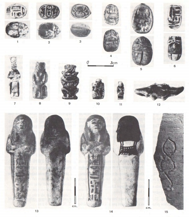
The material culture from tomb 3-P-50 suggest cultural affinities with both Egypt and Nubia. On the Egyptian side, there are figurative scarabs, pendants representing deities and animals, including a rare crocodile pendant, an equally rare wooden headrest, and two late 19th Dynasty shabtis of Isis, lady of the house (figure 3). Various types of beads were also excavated, including long beads and spacers, which are characteristic of elite cemeteries and monumental tombs in New Kingdom Nubia (Lemos 2020). However, various earrings made of shell and carnelian were also found (figure 4), which represent affinities with local styles, which were later exported to Egypt (Lemos 2020). The combination of Egyptian-style objects with stone/ivory/shell earrings and bangles is especially strong at Soleb (Schiff Giorgini 1971).
Tomb 3-P-50 did not belong to a formal cemetery as its material culture alone would suggest. Vila only identified two later (likely Christian) tombs in the vicinity of the site. What is a relatively elaborate tomb containing a large quantity of restricted items typical of large New Kingdom colonial cemeteries doing at Ginis West? There is still so much for us to understand about ‘peripheral’ zones in New Kingdom Nubia. Tombs like 3-P-50 at Ginis West and a few examples from the Batn el-Hajar allow us to think that, at least for some people, what we characterise as ‘peripheries’ were actually the centre of life and death experiences of colonisation in New Kingdom Nubia. My research for DiverseNile will hopefully shed light onto shifting conceptions and experiences of ‘centres’ and ‘peripheries’, which will allow us to rewrite historical narratives of Nubia in the New Kingdom based on local experiences instead of Egyptian ways of classifying history.
References
Binder, M. 2014. Health and Diet in Upper Nubia through Climate and Political Change. A bioarchaeological investigation of health and living conditions at ancient Amara West between 1300 and 800 BC. Unpublished PhD thesis, Durham University.
Donner, G. 1998. The Finnish Nubia Expedition to Sudanese Nubia, 1964–65. Helsinki: Vammalan Kirjapaino Oy.
Edwards, D. ed. 2020. The Archaeological Survey of Sudanese Nubia, 1963-69. Oxford: Archaeopress.
Lemos, R. 2020. Foreign Objects in Local Contexts: Mortuary Objectscapes in Late Colonial Nubia. Unpublished PhD thesis, University of Cambridge.
Schiff Giorgini, M. 1971. Soleb II: Les Nécropoles. Firenze: Sansone.
Spence, K. 2019. New Kingdom Tombs in Lower and Upper Nubia. In Handbook of Ancient Nubia, ed. D. Raue, 541–566. Berlin: De Gruyter.
Vila. A. 1975-79. La prospection archéologique de la vallée du Nil au sud de la Cataracte de Dal. Vols 1-11. Paris: CNRS.
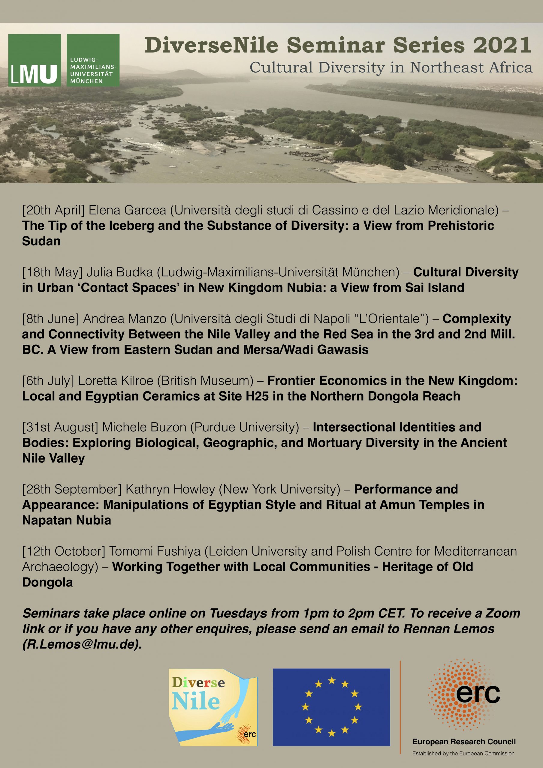
One of the small advantages in the Covid-19 pandemic is that there was a boost of online formats of lectures, seminars and workshops around the world. I consider this especially important since prior to the pandemic, it was a real challenge and a financial issue to ensure the participation of colleagues from Egypt and Sudan, that is, from the countries who’s archaeological remains our discipline investigates. With online formats, the place of stay is almost unimportant, if a stable internet connection is available. Numerous events are already trying to find time slots that are compatible for several time zones around the world. This new form of internationality has enormous potential and the high number of participants in Egyptological events worldwide over the last few months shows that for many people this is an incredible added value – which will hopefully also continue after the pandemic.
Therefore, I am proud to introduce the new DiverseNile Online Seminar Series which will run via Zoom, starting in April. Participation is free but registration via email is mandatory. For composing the programme and the organisation of the seminars, I am very grateful to Rennan Lemos. He did an excellent job, inviting a number of highly distinguished colleagues working in Sudan whose contributions fit perfectly under the general topic of “Cultural Diversity in Northeast Africa”.
Programme of the forthcoming DiverseNile Seminar Series 2021, starting in April!
I am very much looking forward to this new format discussing key issues of the DiverseNile project with an international audience and from various perspectives – fresh ideas are thus as good as guaranteed.
Documentation is the bread and butter of archaeological research. Archaeologists are daily committed to documenting everything: sites formation processes, dwellings, funerary remains, and above all the various products of material culture.
Any method of documentation, from the most essential and traditional (i.e., technical drawing of archaeological strata and finds) to the most elaborated (i.e., image-based 3D-modelling of artefacts, human remains, and sites) constitutes a fundamental step toward archaeological reconstruction. Documentation mainly serves the archaeologist to record and understand the material remains, settlement and funerary features identified during the archaeological excavation and to leave a trace of it. Also, through documentation, a preliminary process of interpretation and critical reading of the data is carried out. Furthermore, the system we adopt to document and classify archaeological data is not unbiased, rather it already implies a methodological choice and a specific scholarly interpretative approach.
As responsible, within the Work Package 3 of the DiverseNile project, for the technological and compositional analyses of the ceramic materials, I want to outline the method I use for the petrographic classification of the ceramic samples which we are going to analyse from the new concession area in the Attab to Ferka region and from our reference collections (e.g., the AcrossBorders ceramic samples from Sai Island; the New Kingdom/Kerma-Dukki Gel pottery samples; see also D’Ercole and Sterba 2018).
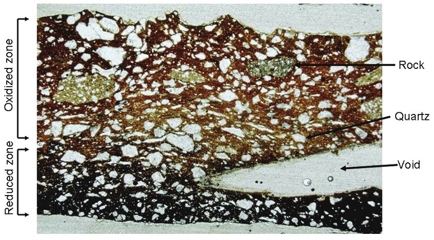
Generally speaking, petrography, via optical microscopy (OM), is a well-established procedure employed to examine ceramic objects and identify the source of clay raw materials and tempers used to manufacture the vessels (Fig. 1). This technique allows answering to crucial archaeological questions on pottery provenance and technology.
Figure 1. Example of ceramic thin section illustrating some common features documented for petrographic analysis. Adapted from Smith 2008: 74, Fig. 6.1.
In Sudanese archaeology, the interest in provenance and technological studies on pottery started approx. 50 years ago. In 1972, Nordström, referring to the work of Anna Shepard (1956), produced a systematic publication on early Nubian ceramics from the region of Abka-Wadi Halfa and defined the term fabric meaning the set of the compositional and anthropogenic characteristics of the ceramic material that could be determined by microscopic observation and comprised both the composition of the groundmass (or clay matrix) and non-plastic inclusions plus the potter’s technological choices adopted to make the vessel.
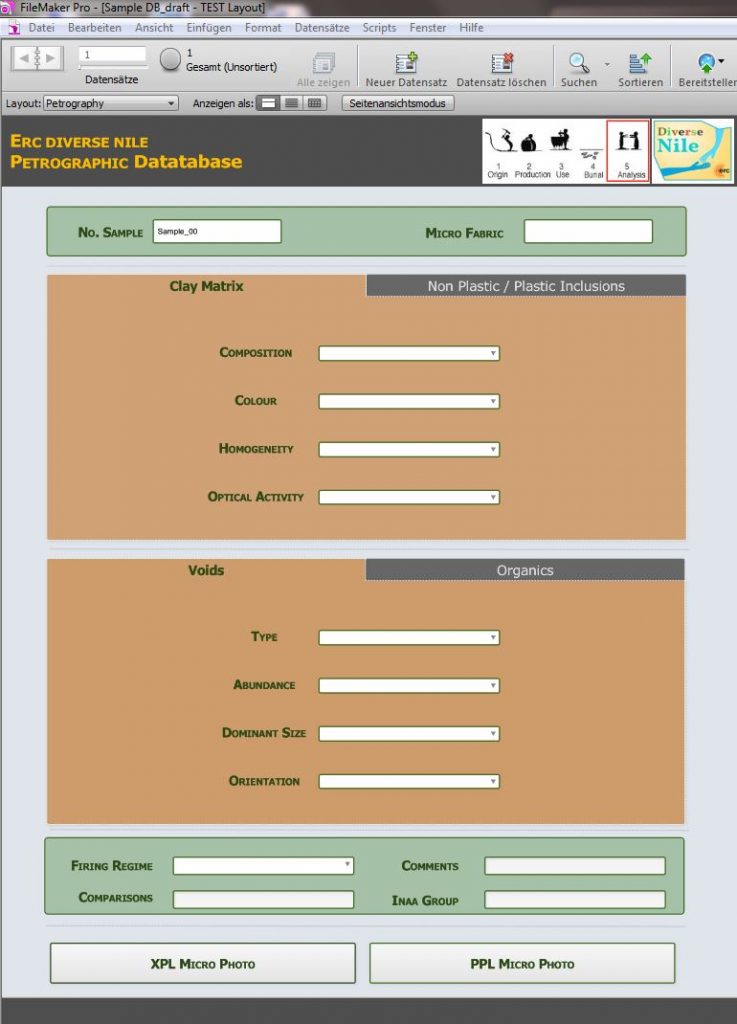
For the study of the ceramic material of our DiverseNile project I have designed a specific petrographic layout within the Filemaker database of the ceramic samples (Fig. 2).
Figure 2. Layout of the petrographic database designed for the DiverseNile project.
The petrographic layout includes information on the archaeological provenance and dating of the samples. It also correlates the micro fabric or petrographic group to the macroscopic evidence, that is the visual description, shape, function, and macro ware of the ceramic specimens. The consecutive entries inform on a) the groundmass or clay matrix of the sample (i.e., colour, homogeneity and optical activity); b) non-plastic inclusions (i.e., sorting, dominant grain size, maximum grain size, abundance, and mineral composition); c) plastic inclusions (i.e., clay pellets, argillaceous rock fragments etc.); d) porosity (i.e., voids abundance, type, dominant size, iso-orientation); e) organics (i.e., abundance, type, dominant size). The database also notifies on the firing regime of the ceramic sample (i.e., oxidised, reduced, reduced with narrow ox margins, dark core due to insufficient ox, oxidised to reduced). Finally, a graphic field incorporates the microscopic photos of the thin section taken under both cross-polarised (XPL) and plane polarised (PPL) light. Comments, possible comparison with other samples, and a link to the iNAA compositional groups are included as further relevant information.
The purpose of this database is to simplify the data entry of the petrographic evidence and to standardize it according to an easy-to-use, flexible, and consistent classificatory system that embraces the main information on the composition and technology of production of the ceramic data (see among others Quinn 2013).
At a subsequent step, this information will be intertwined with the results obtained from the other laboratory analyses and eventually with the archaeological data to provide a further analytical and interpretive tool for understanding the diversity and complexity of the material culture of the human groups living in the periphery of the Egyptian towns in Sudanese Nubia.
References
D’Ercole, G. and Sterba, J. H. 2018. From macro wares to micro fabrics and INAA compositional groups: the Pottery Corpus of the New Kingdom town on Sai Island (northern Sudan), 171–183, in: J. Budka and J. Auenmüller (eds.), From Microcosm to Macrocosm: Individual households and cities in Ancient Egypt and Nubia. Leiden.
Nordström, H. – Å 1972. Neolithic and A-Group sites. Uppsala, Scandinavian University.
Quinn, P. S. 2013. Ceramic Petrography: The Interpretation of Archaeological Pottery & Related Artefacts in Thin Section. Oxford, Archaeopress.
Shepard, A. O. 1956. Ceramics for the Archaeologist. Washington, DC: Carnegie Institution of Washington.
Smith, M. S. 2008. Petrography, Chapter 6, 73-107, in: J. M. Herbert, T. E. Mc Reynold (eds.), Woodland Pottery Sourcing in the Carolina Sandhills. Research Report No. 29, Research Laboratories of Archaeology, University of North Carolina at Chapel Hill.
These are challenging times – for everybody, for many groups more than others (just think of the heroes in hospitals, schools, kindergarten and supermarkets as well as many other places and the awful situation for everybody involved in gastronomy, tourism and culture). We as archaeologists are more or less well prepared for doing much of our work from home. Spending weeks and moths per year in the field, often stuck on an island somewhere, we are also used to a certain kind of isolation.
However, there are of course real problematic issues for us we are currently facing. First of all, of course going to the field in Sudan and Egypt – nothing that is possible at the moment and also planning our next season in the MUAFS concession is still extremely difficult because of the pandemic. Second, our teaching activities are restricted to online formats. Whereas this works without problems for lecture classes and seminars, our planned block seminar “Introduction to field archaeology” where we wanted to have various practical training for our participants would need to be completely revised as an online format. We have postponed it for now, hoping that it might be possible in March – I remain skeptical (or realistic?) since the extension of the lockdown in Munich is very likely, but let’s wait and see. Third, working at home and taking shifts in working in the office to secure isolation and limited risks for everybody is currently without alternative, but I miss having the complete team present and exchanging in a casual way.
Well – as archaeologists we are trained to be patient, and all will be better somewhen!
For now, I wanted to give a small update on our work progress. Everybody of the team is busy with several work tasks within the work packages – much efforts are currently spent by Giulia and Veronica on databases, by Jessica on enlarging our digital library and by Cajetan on various aspects of remote sensing. Rennan was busy with his PhD viva at Cambridge which he passed very successfully and now continues with collecting data useful to approach the mortuary archaeology of the MUAFS concession.
It was very silent from my side as PI and this with good reasons – it is the end of the teaching term, there’s a lot of administration keeping me busy and most importantly: I tried to finish a monograph about Tomb 26 on Sai Island in the last months. This process has taken quite some time and actually benefitted from the lockdown and that I was unable to leave Europe over the winter. This book is now almost ready and I could easy repeat what I had written in 2018 about the merits and flaws of preparing archaeological publications, especially about crazy working hours and panic attacks. And about the feeling of being overwhelmed when you know exactly that the really important things in life are neglected but you can’t help it – partner, family, friends and pets suffer and need to be very patient and supportive (or bribed in the case of animals). Friends and family got used to my slightly bizarre answers on the phone “yes, all is fine, I am still in my tomb, can we speak later?” and for this I am very grateful! Interestingly, there was not much difference between the last months in lockdown and the final book preparation period back in 2018. The results of isolation are just the same, with more silence in the office and maybe with the slight difference that I could not meet friends now, even if I could spare the time.
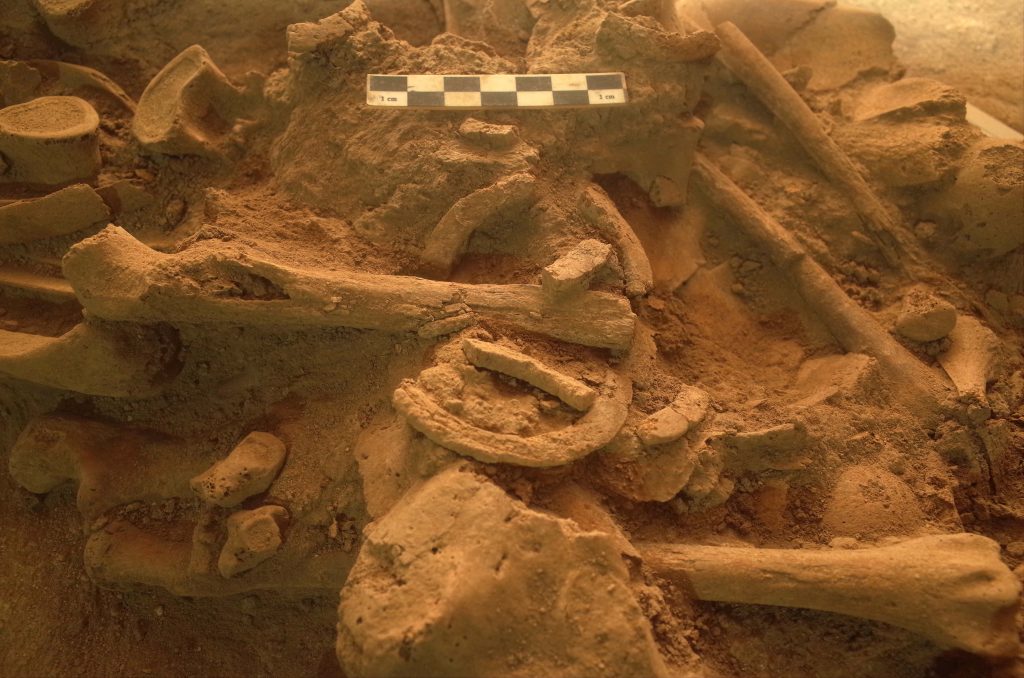
For the DiverseNile project, preparing the AcrossBorders publications is hugely relevant. There are so many aspects we will be able to compare with sites in our new concession which are after all located in the ‘periphery’ of Sai Island. Tomb 26 is one of the Egyptian style pyramid tombs on Sai where the local elite was buried. We had more than 36 burials in this monument and we are now able to reconstruct in detail the life history of the tomb and its users. Although the burial assemblages like the one of Khnummose follow Egyptian standards, there are also certain local markers and individual concepts which I describe in the forthcoming book. We assume that none of the users of Tomb 26 was actually coming from Egypt, all of them are belonging to the local elite with indigenous roots. Interestingly, we also have some Nubian features, especially traceable by the choice of ceramics and bodily adornment.
The probably best example is a young female who was buried with an ivory bracelet in Tomb 26 (Fig. 1). This bracelet was badly damaged and broken, but its find position over the ulna of the individual allowed a clear interpretation. Similar bracelets are known from several New Kingdom sites in Nubia (e.g. Buhen, Mirgissa and Fadrus) and can be regarded as typical ‘Nubian’.
In situ position of ivory bracelet in Tomb 26 on Sai (photo: J. Budka).
Overall, Tomb 26 on Sai Island illustrates as a case study the potential of investigating the variability of funerary practices within a common repertoire of burial customs adopted from Egyptian standards as being rooted in distinct social practices. One of the main tasks for the near future within the framework of the DiverseNile project is, therefore, to determine the degree of diversity not only in elite contexts such as the pyramid cemetery on Sai but also in social groups not belonging to the elite of New Kingdom Nubia in order to achieve a more comprehensive picture of past communities in the Middle Nile region. Our cemeteries in the Attab to Ferka region will allow us to make here considerable progress in the next years, especially because of our joint approach using both funerary and settlement records to reconstruct past communities.
I recently passed my PhD viva at Cambridge and thought it would be nice to provide an overview of the work I’ve been carrying out in the past 4 years, which informs a lot about my research for DiverseNile. Firstly, there are many people to whom I’d like to say thank you—they’re all named in my thesis—but here I will just mention a few key individuals in my journey from Cambridge to Munich: Kate Spence, Stuart Tyson Smith, Paul Lane and our PI Julia Budka.
My thesis is entitled ‘Foreign Objects in Local Contexts: Mortuary Objectscapes in Late Colonial Nubia (16th-11th Century BC)’. From the title, you might be asking what do I mean by ‘Late Colonial Nubia’? It’s not my intention to discuss this here, but in my thesis I argue that we should rethink the terminology we use to describe Nubia’s history from a bottom-up perspective. At this point in my discussion, ‘Late Colonial’ means ‘New Kingdom’ Nubia, although after discussing this with Stuart Smith I realized that there’s more nuance to add to my bottom-up discussion of chronology. I hope to be able to talk about this in more detail soon.
In the Late Colonial Period (or New Kingdom), a huge set of Egyptian-style objects flooded Nubia. This global objectscape appears at various sites from the 1st to the 4th cataract. In my thesis, I explore how colonization materialized differently across Nubia through the reception, adoption and transformation of Egyptian-style objects in local contexts. By examining the social role performed by foreign objects in local contexts in Nubia, my thesis firstly unveils the existence of various burials communities which adopted and combined foreign objects in different ways to fit social spaces’ rules and styles. This is given in the different distributions and combinations of the same types of standardising objects at various sites and social spheres, similarly to the way people around the globe later consumed industrialised tea sets, revealing alternative social structures either potentializing or limiting cultural practices created by the same global objectscape (e.g., cup + saucer versus beaker + saucer).
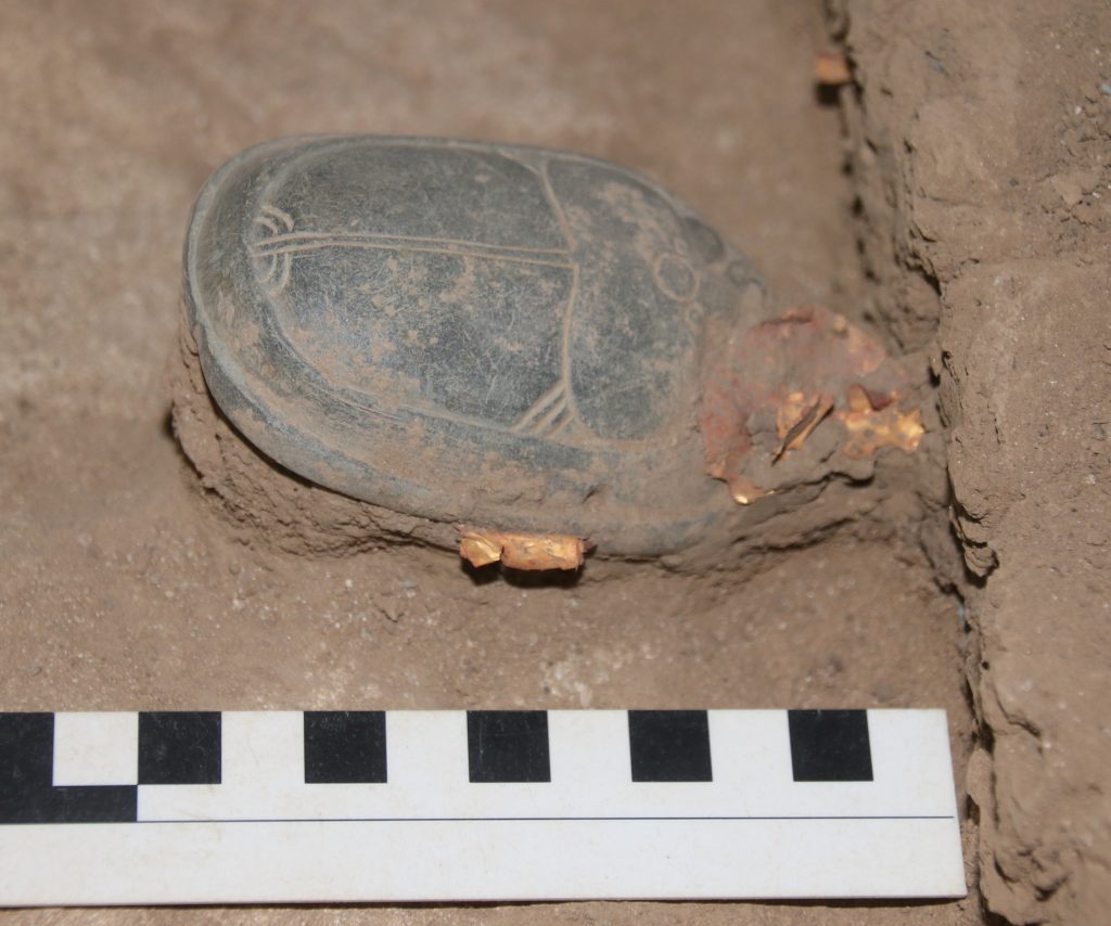
But what kind of social contexts did the same objectscape create in various local contexts? For example, at the same time foreign heart scarabs materialised colonisation, they could also create alternative social contexts within Nubia. Heart scarabs allowed individuals buried at elite sites, e.g. Aniba, Sai or Soleb, to display cultural affinities with Egypt and their power to consume restricted foreign objects, but at the non-elite cemetery of Fadrus, where a single heart scarab was found amongst c. 700 burials, these objects seem to have perform a different role reinforcing community and solidarity. In between extreme alternative social realities (elite versus non-elite), foreign objects were received and adopted in various ways, but also materially transformed or “copied” following local expectations and demands. In my thesis, I discuss more closely the roles performed by standardising scarabs/seals, jewellery, shabtis and heart scarabs in the shaping of alternative social realities within Nubia. This resulted in social complexity and cultural diversity in a context of colonial domination and attempted cultural homogenisation through objects.
Figure 1: in situ heart scarab from Tomb 26 at Sai. Courtesy AcrossBorders Project.
In other words, my thesis investigates how the same types of objects ended up shaping complexity and diversity in Late Colonial/New Kingdom Nubia, despite ancient colonisation and modern homogenising, colonial perspectives to the archaeology of Nubia. My PhD approach informs a great deal about my current research for DiverseNile, which focuses on the variability of mortuary sites and material culture within Nubia, where I have the opportunity to explore in detail a ‘peripheral’ context which becomes the ‘centre’ of alternative experiences of colonisation.
Further reading
Lemos, R. 2020. Material Culture and Colonization in Ancient Nubia: Evidence from the New Kingdom Cemeteries. Encyclopedia of Global Archaeology, ed. C. Smith. https://doi.org/10.1007/978-3-319-51726-1.
Pitts, M. 2019. The Roman Object Revolution. Objectscapes and Intra-Cultural Connectivity in Northwest Europe. Amsterdam: Amsterdam University Press.
Versluys, M.J. (2017). Object-scapes. Towards a Material Constitution of Romaness?. In Materialising Roman Histories, ed. A. van Oyen and M. Pitts. Oxford: Oxbow. 191-199.
Smith, S.T. 2021. The Nubian Experience of Egyptian Domination During the New Kingdom. In The Oxford Handbook of Ancient Nubia, ed. G. Emberling and B.B. Williams. Oxford Handbooks Online https://doi.org/10.1093/oxfordhb/9780190496272.013.20.

