Update on Raman Spectroscopy analysis on Nubian and Egyptian style samples

At the beginning of June, we have announced the launch of a new pilot study – as part of the WP 3 of the DiverseNile project – implementing and testing the potential of the Raman Spectroscopy technique on a selection of ceramic samples coming from our reference collection from the sites of Sai Island (SAV/S-samples) and Dukki Gel, Kerma (DG-samples).

This study is currently in progress as part of our cooperation with the Department of Earth and Environmental Sciences of the LMU, and namely with Fabian Dellefant, co-author of this post, who is a geoscientist and doctoral student under the supervisors of Prof. Dr. Trepmann and Prof. Dr. Gilder.

Due to fast measurements and its non-destructive approach with only little sample preparation, Raman spectroscopy can be easily applied to ancient ceramic materials, answering various technological questions, in particular on the manufacturing stages of production and firing of the pots.

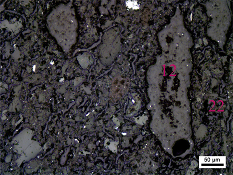
For our investigation, we analysed so far a total number of 8 samples/thin sections (namely samples DG-18, DG-23, DG-29, DG-35, SAV/S 02, SAV/S 14, SAV/S 17, and SAV/S 51). Of all these, micro photos were primarily taken under the petrographic microscope with both transmitted and reflected light in order to select the areas of the sample to be examined with Raman Spectroscopy (normally two different spots including the clay matrix and particular organic components, both within the inner portion or core of the sample and on the rim area).

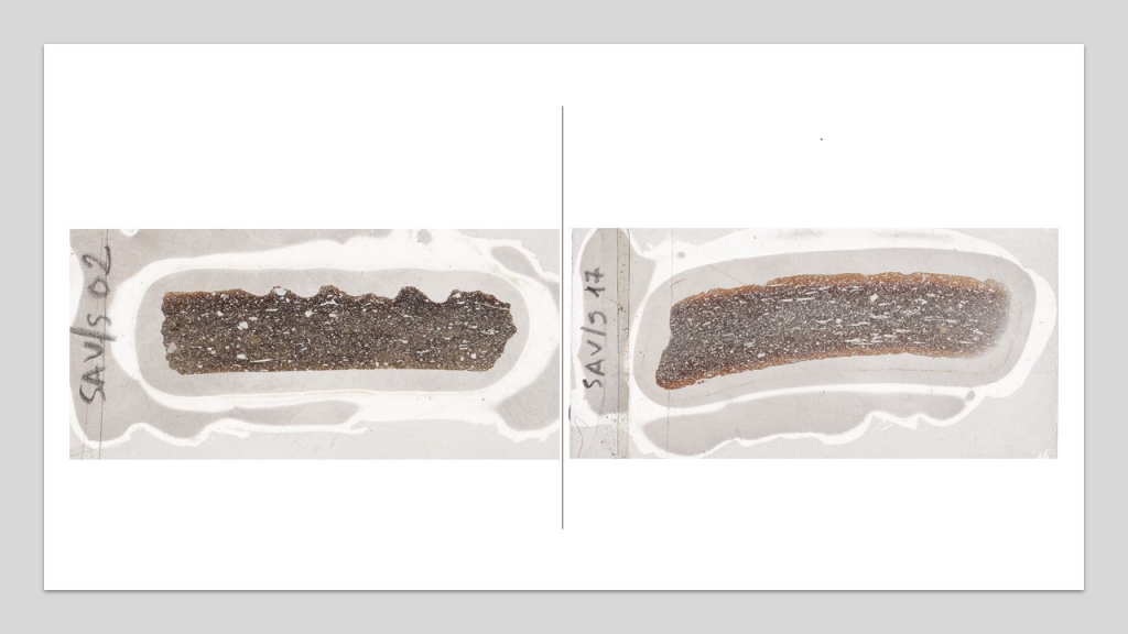
These samples are either locally produced cooking pots or other local ware manufactured both according to the so-called Nubian (DG-18, DG-23, DG-29, and SAV/S 02) and Egyptian style (DG-35, SAV/S 14, SAV/S 17, and SAV/S 51).  All of them consist of a non-calcareous optically active clay matrix with dark cores and red or buff oxidised surfaces. In some specimens, the oxidised margins are narrow and well defined, while in others the red-black zonation appears larger and less regular. The Egyptian style samples normally show a kind of “sandwich” structure consisting of a dark core enclosed, both above and below, by red oxidised surfaces (Fig. 1).

Fig. 1 Photos of the fractures from thin section scanning of samples SAV/S 02 (left) and SAV/S 17 (right). Note the large amount of organic inclusions which have been totally or partially carbonized and are surrounded by voids. Both samples show a dark core due to insufficient penetration of oxygen during firing.

All these samples contain, in a different extent, organic matter either plant remains (chaff, straw, grass and possibly various cereals components), and probably herbivore manure (those finely divided straw particles). The organics are either totally or partially carbonized so that the plant inclusions are often preserved as black carbonized relics into the voids.

The carbonaceous core (dark-grey zone in the center of the ceramic samples) can be the result of insufficient firing under oxidizing conditions. It is also related to the use of a paste of high organic component. During the firing of the pot, the combustion of the organics acts indeed as a reducing agent, taking away oxygen from the firing environment (Velde and Druc 1999: 126-127, see also Quinn 2013).

In organic chemistry, the process of thermal decomposition, obtained by the application of heat and in the complete absence of an oxidizing agent is known as pyrolysis or graphitization.

Pyrolysis-GC/MS to ceramics which are conspicuously black or exhibit a black inner core from incomplete burn-out has been applied for the assessment of molecular properties of organic matter in archaeological pottery matrix (see Kaal et al. 2013).

In Raman Spectroscopy, vibrational modes of specific crystallographic components are used to determine a specific crystallographic structure. In our case, the temperature-dependent formation of graphite is used to quantify the highest temperature the sample has experienced.

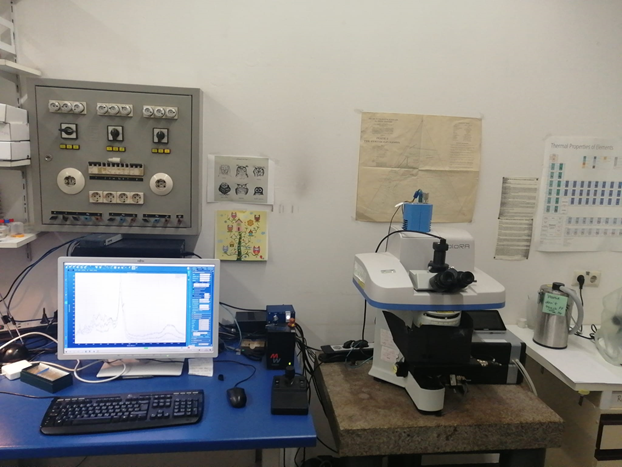
The lab setup consists of an optical microscope with different magnifications and a computer software, which handles data acquisition (Fig. 2). Measurements are conducted by using a laser with a 532 cm-1 wavelength directly on the thin section which has been first well-polished and cleaned with ethanol. In the lab, temperature is kept constant at 18° C degrees with the lights turned off so as not to interfere with the measurement.

Fig. 2 Lab of the Museum Mineralogia in Munich with the optical microscope (right) and the computer (left), which were used for the investigation.

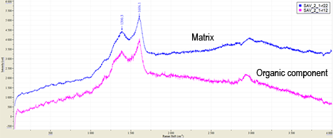
In the investigated ceramics, the precursor of the measured graphite can be either organic material, such as grass and straw, or dung of herbivores, which was mingled into the clay before heating. Furthermore, in some samples firing ash could have been added as well. Our preliminary results show that graphite can be clearly detected in the sample material. Interestingly, a group of samples showed graphite formation only within the organic components, which is interpreted as being the relicts from plant inclusions. Other samples clearly show graphite spectra also within the clay matrix, which could have been added to the clay as ash in the first place (see e.g., SAV/S 02, Fig. 3).

Fig. 3 Optical microphotograph with reflected light of sample SAV/S 02. Datapoint 12 (pink) marks an organic component in a void and refers to the Raman spectra SAV_2_1-r12 in Fig. 4. Datapoint 22 (blue) characterizes the ceramics matrix and refers to the Raman spectra SAV_2_1-r22 in Fig. 4.
Fig. 4 Raman spectra of a datapoint from the matrix and an organic component. The spectrum of the matrix refers to datapoint 22 and the spectrum of the organic component refers to datapoint 12 of Fig. 3.

The interpretation of the maximum temperature the sample experienced is based on the ratio of two Raman peaks, which have a wavenumber of ~1390 cm-1 and 1606 cm-1. Given the dataset shown in Fig. 4, the maximum temperature can be estimated to ~600 °C after Guizani et al. 2017.

In the following weeks, we will proceed to the data processing and potential grouping based on the various Raman spectra collected from our pottery samples (we measured on average up to 20-25 datapoints for each sample). This will allow us to develop our preliminary interpretations and come to more specific conclusions on the quality of the organic material added to the paste and the heating temperatures reached during the firing. Eventually we might get insights on the type of clay sources selected to make the pots.

We can maybe spoil a bit things for you, anticipating that possibly some of the examined samples experienced a more homogeneous firing than others, these latter showing otherwise varying temperatures!

References

Guizani, C., Haddad, K., Limousy, L., and Jeguirim, M. 2017. New insights on the structural evolution of biomass char upon pyrolysis as revealed by the Raman spectroscopy and elemental analysis. Carbon 119:519–521. http://dx.doi.org/10.1016/j.carbon.2017.04.078.

Kaal, J., Lantes-Suárez, O., Martínez CortizasA., Prieto, B., and Prieto Martínez, M. P. 2013. How Useful is Pyrolysis-GC/MS for the Assessment of Molecular Properties of Organic Matter in Archaeological Pottery Matrix? An Exploratory Case Study from North-West Spain. Archaeometry 56 (S1): 187–207. https://doi.org/10.1111/arcm.12057.

Quinn, Patrick S. 2013 Ceramic Petrography. The Interpretation of Archaeological Pottery and Related Artefacts in Thin Section, Oxford.

Velde, Bruce and Druc, Isabelle C. 1999. Archaeological Ceramic Material. Origin and Utilization, Berlin.

Of identities and bodies: new DiverseNile Seminar on mortuary diversity

According to the cold and rainy weather here in Munich, summer has long past – fittingly, our short summer break of the DiverseNile Seminar is now officially over. It is my pleasure to announce the upcoming lecture on Tuesday, August 31: Michele Buzon will be talking about „Intersectional Identities and Bodies: Exploring Biological, Geographic, and Mortuary Diversity in the Ancient Nile Valley“.

Michele is bioarchaeologist and Professor of Anthropology at Purdue University in Indiana, USA. I have the pleasure knowing her since many years, having met her both in Sudan and at conferences. She is the codirector of the important excavations at Tombos and we were therefore always in close contact during my AcrossBorders project. Our assessment of the strontium isotope analysis from Sai could nicely built on data published by her and co-authors. As I outlined in an earlier post, only common efforts will allow us to establish a strontium isoscape for New Kingdom Nubia and much work is still waiting for all of us.

Michele is one of the key figures in modern Nubian bioarchaeology conducting contextualized interpretations that combine skeletal evidence with settlement, environmental, and mortuary data. This approach allows to create a more nuanced picture of life and death in ancient Nubia (see also her recent summary of Bioarchaeology of Nubia in the Oxford Handbook of Ancient Nubia, Buzon 2021).

I am very much looking forward to her presentation and hope that many of you will be joining us – without doubts, Michele is going to show exciting material, fresh data and will offer much food for thought! As usual, late registration for our DiverseNile seminar is still possible via email.

Reference

Buzon, Michele R. 2021. Bioarchaeology of Nubia, in: The Oxford Handbook of Ancient Nubia, edited by Geoff Emberling and Bruce Beyer Williams, Oxford, DOI: 10.1093/oxfordhb/9780190496272.013.55

Where’s the population of New Kingdom colonial Nubia?

David Edwards‘ recent publication of ‚Pharaonic‘ remains in the Batn el-Hajar provides an important comparison point for us to understand the evidence from DiverseNile’s concession area from Attab to Ferka. From a mortuary landscape perspective, Edwards criticises archaeology’s traditional focus on elite tombs in the Middle Nile saying that we „should not narrow our perspectives, to the exclusion from our narratives of the vast majority of the population who were buried otherwise“ in areas other than the centres of foreign colonial power in Nubia (Edwards 2020: 396).

Until recently, a similar picture could be drawn for Egypt. Despite large non-elite cemeteries being known since the early 20th century (e.g., Matmar or Gurob), a monumental/elite bias characterised historical narratives about New Kingdom Egypt (see Richards 2005). Only recently, with the identification and excavation of large non-elite cemeteries at Amarna (Kemp et al. 2013), more scholars are paying attention to other social realities beyond the imposition of elite social spaces.

The long history of archaeology in the Middle Nile has been strongly marked by colonisation, ancient and modern. Nubia’s history, especially in the New Kingdom, has remained, for a long time, in the shadow of Egypt’s history. This manifested as the discipline’s Egyptocentric focus on sites of colonial administration, its textual sources and elite cemeteries, which yielded Egyptian-style objects interpreted as essentially ‚Egyptian’—a manifestation of the alleged acculturation of passive local communities placed in lower ranks of ‚civilisation‘. Traditional, Egyptocentric research agendas contributed further to silencing past colonised groups, which only appear in Egyptian textual sources in inferior positions.

As a result, we still know barely anything about the majority of the population of New Kingdom Nubia, which inhabited areas other than the major colonial centres of power, e.g., Aniba, Sai, Soleb. The cemeteries at these sites house a small number of monumental tombs that, although used collectively, still represent a tiny fraction of society across the history of ancient colonial Nubia.

Who were the majority of the population of New Kingdom Nubia? Where did those people live and where were they buried? Where did they come from? Under what conditions did they live (and die)? Although research is moving forward to address new topics (see Spencer et al. 2017), these are questions that haven’t been explored for Nubia yet, mostly due to archaeology’s focus on acculturation/Egyptianisation in the New Kingdom.

Areas such as the Batn el-Hajar and the region south of Dal cataract, including DiverseNile’s concession from Attab to Ferka, are unlikely to yield monumental elite tombs. However, peripheral, today inhospitable desert areas along the Middle Nile hold an enormous potential to impact our narratives about ancient Nubia’s colonial past, shedding light on alternative histories, experiences and forms of being-in-the-world beyond Egyptological/Egyptocentric research interests grounded on sites of Egyptian colonial administration in the New Kingdom. So, where did the majority of the population live and die in New Kingdom Nubia? Likely in the geographical and social gaps along the Nile still to be fully explored.

Even at colonial administrative centres, such as Aniba, Sai and Soleb, social relations were more complex than simply being ‚Egyptian‘. Recent work confirmed, through isotopic analysis, that local individuals lived at those sites and worked in colonial administration; e.g., the master of goldsmiths Khnumose and other individuals close to him (Budka 2021). My previous work on the distribution and use of Egyptian-style objects in local contexts in colonial Nubia, which included subversive transformations of stylistic and use patterns, also show that things weren’t homogenous in colonial Nubia (Lemos 2020).

Currently, we know very few non-elite cemeteries in New Kingdom colonial Nubia. If social relations were far from being uniform at colonial centres of power, at non-elite cemeteries there was even more room for negotiations, which resulted in the shaping of alternative material realities and experiences of colonisation. Examples from non-elite cemetery of Fadrus in Lower Nubia allow us to understand better such negotiations, which could result in alternative social relations other than imposed colonial hierarchies (e.g., collective engagement and collaboration), as I have argued in a forthcoming paper (Lemos forthcoming).

Fadrus alone doesn’t fill the gap in our knowledge about the vast majority of the population of New Kingdom colonial Nubia, neither does the collective use of elite tombs at the centres of colonial administration. In both elite, administrative sites and non-elite sites, Egyptian-style material culture opens windows to complexity and diversity beyond previous homogenising interpretations of New Kingdom colonial Nubia that reflect disciplinary colonial traditions and interests. Therefore, turning our attention to ‚peripheral‘ regions previously neglected holds an immense potential for us not only to detect this vast mass of population left out of historical narratives, but also to uncover alternatives to colonial homogenisation (ancient and modern) through people’s diverse experiences of landscape, society and culture.

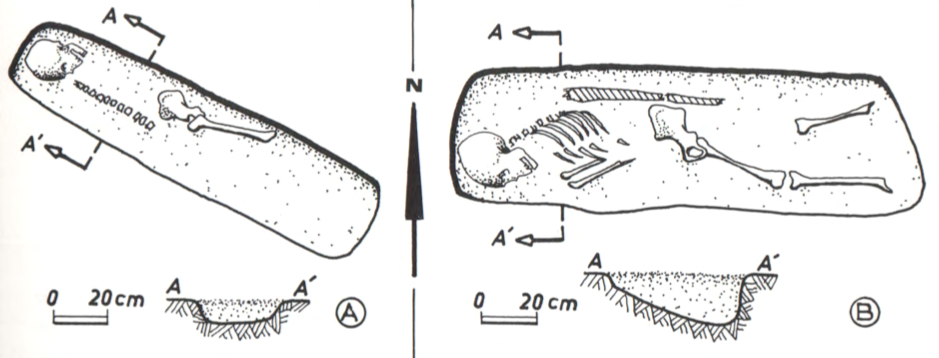
Fig. 1: non-elite graves at Ginis East (Villa 1977: 39).

Vila’s survey identified several burial sites, which are comparable to non-elite cemeteries, although most of the Vila sites don’t seem to be large „formal“ cemeteries like Fadrus (figure 1). DiverseNile’s focus on the regions where the majority of the population of the New Kingdom colonial Nubia lived and died is an important step towards understanding diversity and complexity in heterogeneous New Kingdom Nubia. Exploring such sites in comparison with other sites in Nubia holds a huge potential for us to rewrite Nubia’s diverse history in the New Kingdom, which was characterised by various, sometimes competing material experiences of colonisation, especially considering the creative potential of people living and dying at the fringes of society.

References

Budka, J. forthcoming 2021. Tomb 26 on Sai island: A New Kingdom elite tomb and its relevance for Sai and beyond. Leiden: Sidestone Press.

Edwards, D. 2020. The Archaeological Survey of Sudanese Nubia, 1963-69. Oxford: Archaeopress.

Kemp, B. J. et al. 2013. Life, Death and Beyond in Akhenaten’s Egypt: Excavating the South Tombs Cemetery at Amarna. Antiquity 87: 64–78.

Lemos, R. 2020. Material culture and colonization in ancient Nubia: Evidence from the New Kingdom cemeteries. Encyclopedia of Global Archaeology, ed. C. Smith. https://doi.org/10.1007/978-3-319-51726-1.

Lemos, R. forthcoming 2022. Heart Scarabs and other heart-related objects in New Kingdom Nubia. Sudan & Nubia 25.

Richards, R. 2005. Society and death in ancient Egypt. Cambridge: CUP.

Spencer, N. et al. 2017. Introduction: History and historiography of a colonial entanglement, and the shaping of new archaeologies for Nubia in the New Kingdom. In Nubia in the New Kingdom: Lived experience, pharaonic control and indigenous traditions, ed. N. Spencer, A. Stevens and M. Binder, 1–61. Leuven: Peeters.

Vila, A. 1977. La prospection archeologique de la valee du Nil au sud de la cataracte de Dal 5. Paris: CNRS.

A View from Sai Island

Tomorrow, the second lecture of our DiverseNile Seminar will take place. This time, it will be me presenting and I will talk about “Cultural Diversity in Urban ‚Contact Spaces‘ in New Kingdom Nubia: A View from Sai Island”.

Sai Island is one of the prime case studies to investigate settlement patterns in New Kingdom Nubia. In tomorrow’s presentation, I will focus on state-built foundations like Sai as colonial urban sites and their hinterland. I will explain why I introduced the concept of ‘contact space biography’ for the DiverseNile project and outline this approach.

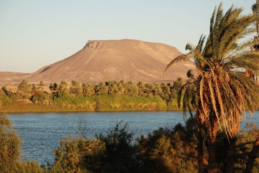
A view from Sai Island: here towards Gebel Abri.

The starting point for my new research in the Attab to Ferka region were several open questions deriving from my work on Sai between 2011-2018 – tomorrow, I will address some of them, stressing why a view from a colonial temple town is crucial to understand cultural dynamics in rural and peripheral regions of the Middle Nile.

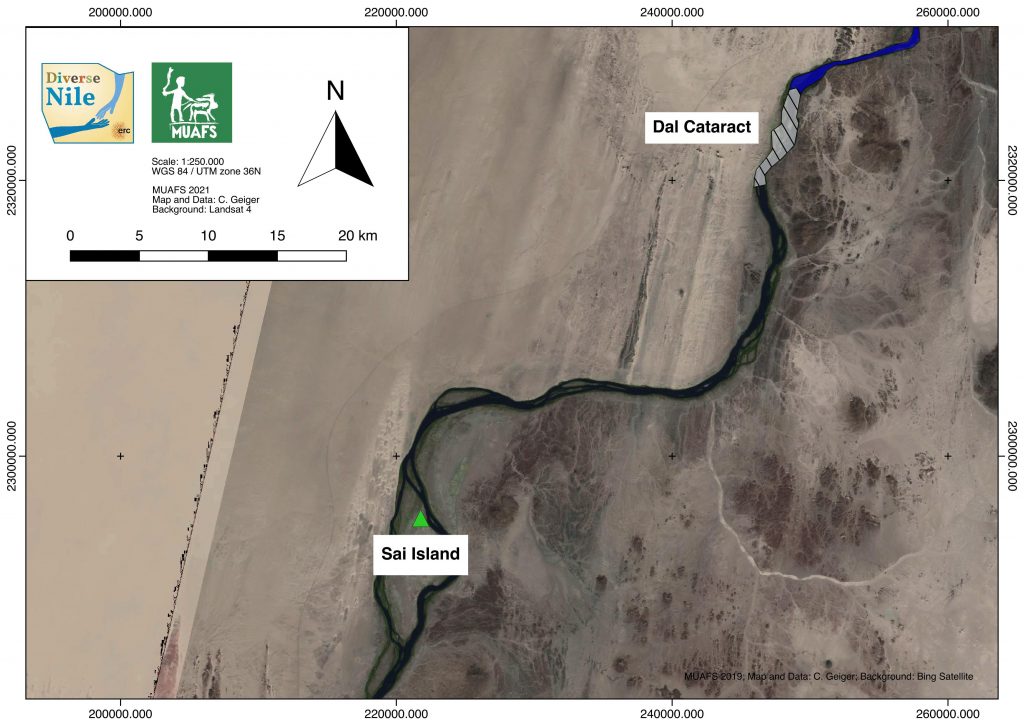
The location of Sai Island in the Middle Nile.

Since time is limited, I will select some examples to address cultural diversity in New Kingdom Nubia: the use of the so-called fire dogs and the question of cooking pots as well as foodways in general. For the latter, I would like to introduce the ‘food system’ concept as presented by Kelly Reed in a brand-new article which provides much food for thought. Reed argues that with such an approach, archaeologists are required to consider „all the processes and infrastructure involved in feeding a population“ (Reed 2021, 57). This does seem particularly fitting for the DiverseNile project and our aims.  I also very much like her attempt to apply system theory and social-network analyses to highlight the multiple links between society, environment and food. Within our contact space of the Attab to Ferka region, we also want to identify the specific stakeholders (actors such as families, individuals and official institutions as well as the ‚goverment‘, thus the Egyptian state) of this ancient Bronze Age ‘food system’ and thus presumably showing complex connections between the urban sites of Sai and Amara West and their hinterland with rural sites like villages at Ginis and Kosha. New information on food supply and distribution systems will be highly relevant to reconstruct contact space biographies in our project. Last, but definitly not least, the peripheral settlements in our research concession were always an integral part of the ‘food system’ of Sai and contributed to the dynamics we can trace in this state-built foundation (cf. Sulas and Pikirayi 2020, 80).

For more, please zoom in tomorrow at 1pm, late registrations are of course  still welcome!

References:

Reed, K. 2021. Food systems in archaeology. Examining production and consumption in the past. Archaeological Dialogues, 28(1), 51-75. doi:10.1017/S1380203821000088

Sulas, Federica and Pikirayi, Innocent 2020. From Centre-Periphery Models to Textured Urban Landscapes: Comparative Perspectives from Sub-Saharan Africa, Journal of Urban Archaeology 1, 67–83 https://www.brepolsonline.net/doi/epdf/10.1484/J.JUA.5.120910

Evidence for Kerma settlements and an intriguing dry-stone structure in Kosha East

Studying Kerma remains in the MUAFS concession area will provide fresh and urgently needed input for manifold, still open questions about a region far north of the Kerma capital, as our PI Julia Budka stated lately in her article about the Kerma presence in Ginis East (Budka 2020).

Today, I would like to give a short outlook over the settlements of the Kerma horizon in the Attab to Ferka region and exemplarily introducing you to an intriguing site, which seems to hold the potential for further thought (for Kerma tombs in Attab to Ferka see the blog entry of my colleague Rennan Lemos with his presentation of a fascinating Kerma burial).

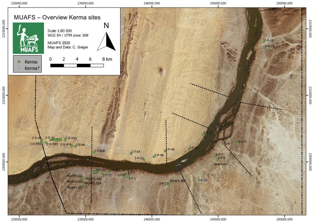
Currently, 30 settlements classified as Kerma are included in our database – whereby Egyptian New Kingdom presence at some of them and vice versa clearly illustrates the need to move away from the previous used interpretation of sites as rigid ‘Egyptian and ‘Nubian’ cultural units, addressing them as more closer interconnected cultures in this region (Budka 2020: 63).

Concerning their location, the settlements with Kerma presence are consistently distributed between both river banks with a certain dominance (18) on the right bank. Kerma sites on the left bank (12) were often situated in an impressive distance from the modern Nile, thus following the ancient course of the river. Besides a striking number of Kerma remains in the districts Attab and Ginis, Kerma sites can also be traced much further north (see Fig. 1).

Figure 1: Kerma sites in the region from Attab to Ferka (status 2020). Budka 2020: fig. 13 (modified).

These observations will not only shed further light on Sai during the Kerma period and its periphery, or the northern borders of the Kerma kingdom. Particularly important will be the insight how people lived there in the period of the New Kingdom occupation of Nubia – how the diverse social and cultural groups interacted with each other away from the major urban centres, collectively shaping, exploiting and making the landscape their home (Budka 2020: 63, Budka 2019: 24).

In a contact space like Attab to Ferka, it is the physical manifestations of the living that can shed light on how a cultural exchange could have happened, not only through the adoption or modification of ‘Egyptian’ patterns by the Nubians, but clearly vice versa – visible in the choice of design or used building material. Concerning the latter, with the fascinating site we will have a closer look now, I will focus today on dry-stone as building technique – a method Liszka states that “appears to have been passed down through generations of Nubians for many millennia” (Liszka 2017: 41).

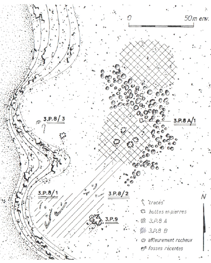
Besides the material the second characteristic of this site, detected by Vila and his team at Mindiq and numbered as NF-36-M/3-P-8 is its location further in the north of the MUAFS concession (Vila 1976: 90–96). More precisely the archaeological remains were found in the north-eastern part of Kosha East, situated in an impressive distance of 750 m to the modern Nile on the first hills rising 10 to 12m above the Kosha plain. The site occupied an overall surface of 200 x 60m (NE-SW), with intermediate sterile zones.Within this area, the areal NF-36-M/3-P-8A/B is from special interest (Fig. 2), being categorised by Vila as habitation site – a term he specifically used for remains of organised structures, perhaps being once a permanent settlement.

Whereas Vila still proposed a Neolithic or Nubien Ancien/Moyen context of the site, his attribution could be revised by our PI during our last campaign, giving, besides the Neolithic, a presumptive Old or Middle Kerma date, based on a large number of Kerma pottery.

Looking closer at Vila’s description of the character and the nature of the site, the division in 3-P-8A and 3-P-8B is explained by the existence of stone structures together with sherds and stone tools in part 3-P-8A at the centre and in the northern part of the site, whereas 3-P-8B consisted of a massive amount of stone tools scattered all over the site, with a certain concentration in the southern part, where no sherds were found.

Figure 2: Mindiq, General sketch plan of site NF-36-M/3-P-8A/B (Kosha E). Vila 1976: fig. 41 (modified).

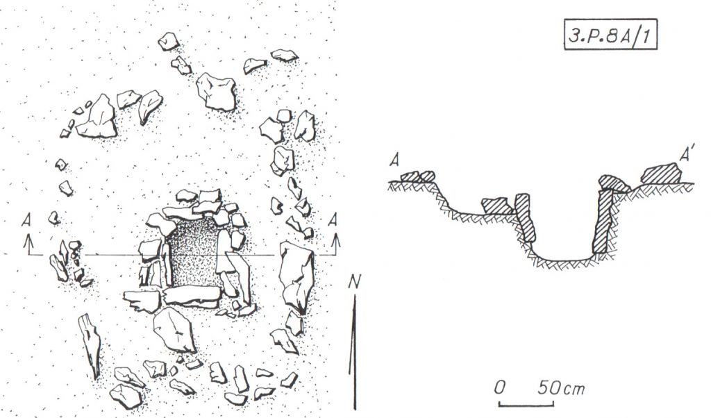
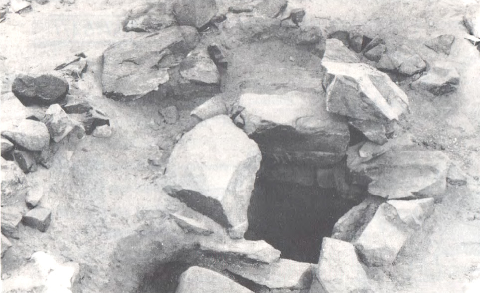
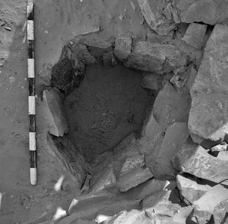
Concerning the questions of used material and building techniques the design of the stone remains in 3-P-8A are highly interesting – for a tentative interpretation of the site’s purpose also the nature of 3-P-8B can add some hints. In 3-P-8A Vila noted the remains of five dry stone huts – and in close proximity to them (originally connected?) – a feature from special interest (3-P-8A/1) (only) for which he gave a more detailed sketch plan and description: Its visible remains consisted of a quite circular structure made of stone blocks (possibly continuing with similar adjoining structures further north) with a diameter of approx. 4m. Within this stone structure the most interesting detail is a square stone-lined bin measuring approx. 60 cm x 60cm, with a depth of around 50/60cm, whose vertical walls were reinforced with raised slabs (Figs. 3a, b).

Figure 3a: Sketch plan and section of circular structure with stone-lined bin (NF-36-M/3-P-8A/1). (Vila 1976: fig. 42).
Figure 3b: Detail of stone-lined bin in NF-36-M/3-P-8A/1, view towards S. (Vila 1976: fig. 44.1).

When visiting the place in the 1970ies, Vila and his team noted a heavily disturbed area in the northern part of the site, dividing 3-P-8A in two zones (Fig. 2), and consisting of pits of modern stone extractions. A similar picture emerged during our visit in the last campaign, when we found the site badly damaged by modern gold mining. These endangering activities not only clearly illustrate the urgent need of our research in the MUAFS concession, but also the richness of resources of this region, especially in this area, still being extracted today.

Thus, together with the abundance of stone tools indicated by Vila in 3-P-8A/B – further attested by the numerous quartz flakes we found on site – may point to an original purpose of the site associated with gold processing activities. In this context, one may wonder what role the above mentioned stone-lined bin might have played and if the architectural nature of the site 3-P-8/A with its dry-stone constructions could strengthen this assumption? Looking outside the box – thus beyond the MUAFS research area to other comparable frontier and contact spaces of similar time periods within Nubia may help to gain more thought-provoking hints.

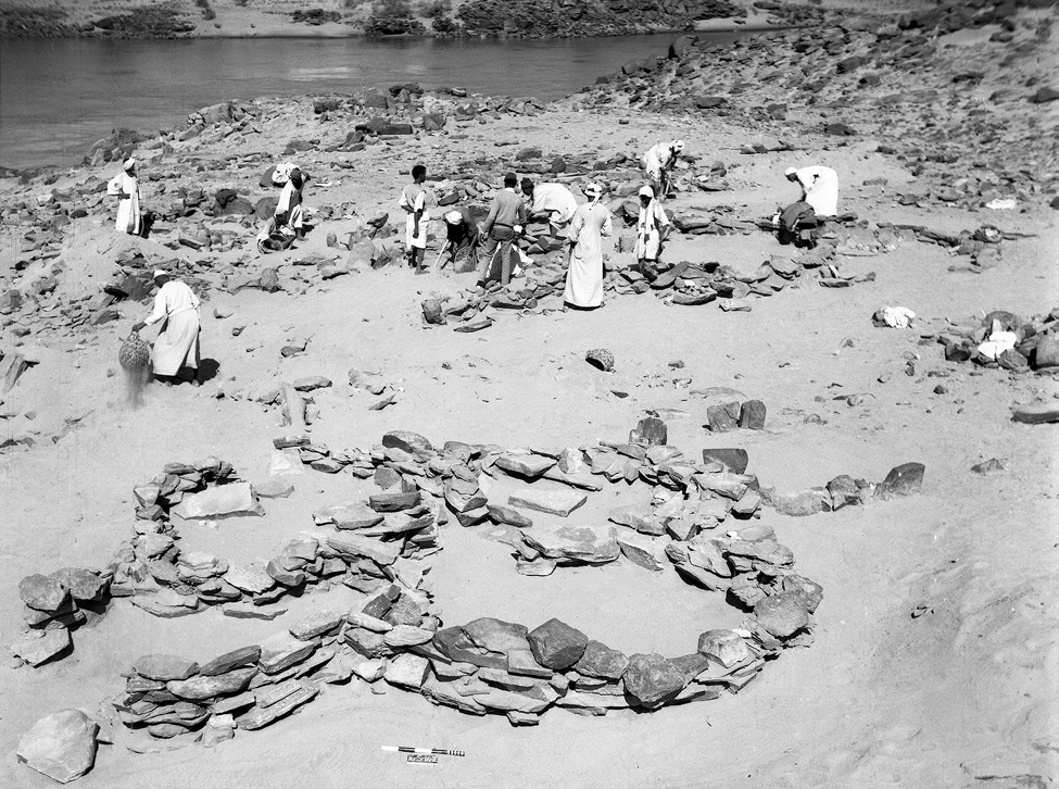
Here I will just refer to the evidence in the Batn el-Hagar, recently published by Edwards who introduced the occurrence of a fascinating category of Pharaonic sites, that clearly outnumbered other types of settlements in this region. Besides their number, their peculiarity consists especially of their dry-stone architecture and their often curvilinear layout – representing as Edwards stated “a still unfamiliar form of an ‘Egyptian’ presence” in Nubia (Edwards 2020: 378). These sites were apparently linked to gold mining activities within the region, which is why Edwards refers to them as ‘workshop sites’. Mostly situated in larger distances to the Nile their architecture consists of a number or dry-stone walls forming complexes of subcircular or curvilinear rooms. The different equipment found in these rooms points to different working units and working steps, as illustrated by large granite mortars and grinding installations of diverse types – but it is especially indicated by numerous stone-lined bins or tanks (Fig. 4) comparable to “our” example from Mindiq. Some of the latter seemed to be originally associated withworking processes using water and still contained accumulations of fine water-laid crushed gold bearing quartz (Edwards 2020: 404).

Figure 4: Example of a stone-lined bin (diam: 55 cm, depth: 45 cm, workshop site 11-Q-61, Saras E). Edwards 2020: fig. 3.3.31.

Concerning the rather unusual ‘Egyptian’ architectural appearance of those workshop sites, Edwards suggested a possible more complex history of Egyptian gold mining in this region – and a very plausible stronger role of Nubians in this context. His assumption was not only based on often found Nubian or Kerma style pottery within these workshops (f. ex. Duweishat area, workshop 16-O-12, Attiri – Sorki, with even a predominance of Nubian style ceramics, Edwards 2020: 226–234), but also on the existence of at least one similar site clearly dating in the Middle Kerma period (Duweishat area, workshop 16-S-16, also addressed as ‘Kerma/C-Group’ workshop site). The layout, finds and crushed quartz debris of his clearly Nubian site hold striking similarities to those qualified as Pharaonic workshop sites in this region (Edwards 2020: 406–407).

Figure 5: ‘Kerma/C-Group’ workshop site (16-S-16, Duweishat), 1967. Several large grindstones are visible at floor level of the nearest structure. Edwards 2020: Fig. 7.32.

Returning to our site in Kosha E, 3-P-8A/B, it would be tempting not only to assume a similar functional purpose, but – indicated by the today still visible remains – an original possibly related architectural layout. With clearly still needed further research in the coming years, this site with its presumed Old and Middle Kerma context already is from special interest due to its possible earlier date than the aforementioned site 16-S-16 in the Duweishat region. Thus site 3-P-8A/B, holds not only important hints about the gold-working activities in the Attab to Ferka area but also may help to shed further light on early Nubian gold exploitation.

Not least this early site has the potential to deeper explore the still pending ‘chicken or the egg-problem’ – so the question (is it) ‘Egyptian or Nubian?’ that Liszka chose concisely as title of her important article (Liszka 2017) on the matter of dry-stone architecture in Nubia in ‘Egyptian’ contexts. It is precisely such sites, that not only allow us to find answers concerning the activities of ancient people living there and the reasons for the choice of diverse building techniques, for different materials or locations (f. ex. being possible rather pragmatic choices depending on the better availability of stone or are they rather hinting to an internal cultural variability? Or point they to a rather seasonal occupation resp. are explained by the sites purpose?). But most importantly, architectural remains, such as these dry-stone buildings used by ‘Nubians’ or ‘Egyptians’ can also contribute to reconstruct the dynamics of such an ancient ‘contact space’ as the Attab and Ferka region – does it point, f. ex. to knowledge transfer throughout the times and cultures or to the inclusion of craftsmanship of well-trained people, thus not only resulting in acceptance or appropriation of various cultural influences, but also in possible fusions creating together something new.

In this regard – stay tuned for further insights in the fascinating topic of exploring the settlement-scape and the nature of living in the Attab to Ferka region!

References

Budka, J. 2019 (with contributions by G. D’Ercole, C. Geiger, V. Hinterhuber and M. Scheiblecker). Towards Middle Nile Biographies: the Munich University Attab to Ferka Survey Project 2018/2019, in: Sudan & Nubia 23, 13–26.

Budka, J. 2020. Kerma presence at Ginis East: The 2020 season of the Munich University Attab to Ferka Survey Project, in: Sudan & Nubia 24, 57–71.

Edwards, D.N (ed.). 2020. The Archaeological Survey of Sudanese Nubia, 1963–69. The Pharaonic Sites. Oxford.

Liszka, K. 2017. Egyptian or Nubian? Dry-Stone Architecture at Wadi el-Hudi, Wadi es-Sebua, and the Eastern Desert’, in: Journal of Egyptian Archaeology 103(1), 35–51.

Vila. A. 1976. La prospection archéologique de la vallée du Nil au sud de la Cataracte de Dal. Fascicule 4. District de Mograkka (Est et Ouest). District de Kosha (Est et Ouest).Paris.

Discussing theory and methodology

I’ve been really busy with several commitments besides my research project, but I’d like to give you a quick update about what I’ve been up to lately. As you know, my WP2 research focuses specifically on the data collected by Vila within the region from Attab to Ferka. However, in order to have a more comprehensive idea of the significance of this data, comparison with other regions is a key aspect of my methodology. If sites such as tomb 3-P-50 at Ginis West allow us to start challenging ingrained conceptions about society and culture in New Kingdom Nubia, e.g., colonial ‘centres’ and ‘peripheries’, putting sites like this into a broader context is a really important step.

In previous posts, I stressed the importance of data sets like those produced by the ASSN or the Finish Expedition in the Batn el-Hajar area, as well as sites in the 4th cataract. But comparative research shouldn’t be limited to feeding information from different sites into a database, although it remains an important aspect of my research. A descriptive approach to data would allow us to identify previously ignored data, especially for regions that are not usually part of major narratives about Nubia, e.g., the Attab-Ferka area. However, a clear theoretical approach allows us to abstract descriptions into understandings of broader social phenomena.

I’ve recently been invited to speak in the New Perspectives on Ancient Nubia seminar series, co-hosted by the Bade Museum and University of California Berkeley. In my talk, I discussed the role and potential of postcolonial and decolonial theory for New Kingdom Nubia. A broader theoretical approach allows us to bring together evidence from different contexts into a general narrative about social logics that both produce and are produced by the material culture we investigate and describe in our databases.

Postcolonial theory has had a huge impact in archaeology, although its role in the Nile valley has not always been that explicit. Postcolonial theory provides us with a framework from which we’re able to criticise colonial narratives and practices, but also to unveil hidden, silenced logics that have remained outside mainstream historical narratives. This is highly important for the DiverseNile theoretical and methodological framework.

Egyptian-style material culture has been understood, as whole, through a generalising lens that emphasised the Egyptian presence and transposition of knowledges and practices to an acculturated Nubia. My research in the last few years allowed to unveil, from a postcolonial perspective, alternative realities created by transformed foreign objects in local contexts in New Kingdom Nubia (I explore this further in a forthcoming paper on heart scarabs, which will be published in the next issue of Sudan & Nubia). So, developing and applying a postcolonial approach to our data from the region from Attab to Ferka, combined with information from the very centres of colonial power in New Kingdom Nubia, will certainly shed more light on the substance of diversity, allowing us to include regions traditionally excluded from historical narratives into histories of alternative experiences created and sustained by alternatives roles performed by spreading material culture. That’s a bit of what I’ve been reading, thinking and writing lately. I’d be happy to think about these issues together with anyone interested!

Kerma Tombs from Attab to Ferka

Sudan & Nubia 24 is now out and it includes a paper by PI Julia Budka on the Kerma presence at Ginis East (Budka 2020). The paper also presents an updated overview of MUAFS fieldwork, which relates to my work in the DiverseNile Project focusing on Kerma, New Kingdom and early Napatan cemeteries in the region. In the past three seasons, the MUAFS team reidentified hundreds of sites firstly described by Vila, but also identified 40 additional sites so far, including tombs which are of interest to my subproject. In my previous posts, I have focused mainly on the New Kingdom. Here I will present a brief overview of the Kerma presence, as attested by cemetery sites and isolated tombs, in Attab-Ferka (figure 1).

Figure 1: Kerma sites in the region from Attab to Ferka (status 2020). Budka 2020, fig. 13.

I have previously mentioned that, for the New Kingdom, our knowledge is mainly based on evidence from major colonial settlements and cemeteries. There are clear geographical gaps in what we know about the Egyptian colonisation of Nubia in areas such as the Batn el-Hajjar (Edwards 2020) or the MUAFS concession area. A similar situation occurs during the Kerma Period. As Julia Budka pointed out in her recent S&N paper, evidence from Attab-Ferka is extremely relevant “to address the issue of the borders of the Kerma kingdom as well as cultural manifestations of what has been labelled as ‘rural Kerma’” (Budka 2020: 63).

Veronica Hinterhuber’s last post provided an overview of her general database of sites based on information published by Vila. Her work is invaluable for my preliminary assessment of mortuary sites in our concession area. Based on her database, 10 mortuary sites first identified by Vila as dating to the Kerma Period can help us to preliminarily understand the Kerma spread in the region. Recent fieldwork has identified a large degree of destruction and plundering at those sites, which makes it important to revisit previously published and archival data with a fresh mindset to extract valuable information. Comparison with other sites, especially those at the Kerma hinterland and other ‘peripheral’ zones across Nubia, also help us shed light onto blurred spots in our datasets from Attab-Ferka.

Besides the overall plundering, Kerma tombs in the region were tumuli with granite superstructures (usually not preserved) and oval or large rectangular pits containing bone fragments, sherds and very rarely burial goods (e.g., faience beads). Kerma tombs were either larger, aprioristically isolated tombs or part of cemeteries grouping a higher number of burials; e.g., at Ferka East and Kosha East. A few skeletons were found in situ, although plundered. They were all deposited in a flexed position, sometimes on a bed; e.g. at Ferka East. Kerma tombs were reused in the Christian Period. For instance, one wrapped body dating to this period was found inside a Kerma tomb at Kitfogga, Ferka East. Sherds usually include Kerma beakers and goblets. Due to plundering, it is difficult to determine, based on the amount of information currently available, whether these burials were characterised by a simple approach to graves goods or not. Comparison with sites such as Abu Fatima, where Stuart Tyson Smith and Sarah Schrader are currently working, should allow us to gain a better picture of continuity and variation in Kerma contact spaces between, for instance, elites and non-elites or urban and rural communities.

The region from Attab to Ferka was not only a contact space within the Kerma state. It was also an area where the Kerma ‘culture’ interacted with Egyptian patterns. For example, one very interesting burial was excavated by Vila at Shagun Dukki, Ginis East, where c. 10 other tombs were detected (figure 2). It consisted of a shallow, oval pit inside of which a flexed skeleton was found (disturbed). Together with the skeleton, a bone scarab was found in the right hand, a common pattern at Classic Kerma burials at Kerma city (Minor 2012: 144). Most scarabs found at Kerma city bear similarities with scarabs from Second Intermediate Period Egypt and Syria-Palestine and would have been acquired either via trade or reuse of graves in Lower Nubia (Minor 2012: 138-140). It is difficult to read the signs on the base of the scarab from Shagun Dukki. Moreover, bone was a material used to manufacture various items in the Kerma Period, as well as among other Nubian communities, and worked as a Nubian identity marker in the New Kingdom. Were bone scarabs the result of local copying practices? Looking at the evidence from Attab-Ferka holds the potential to shed light on internal contact and variability within the Kerma realm, as well as the local roles of foreign objects in local contexts in this period.

Figure 2: A Kerma burial at Shagun Dukki, Ginis East (Vila 1977: 25).

Gratien has previously pointed out how little we know about the Kerma state outside Kerma city, as well as how the Kerma state related to other ‘Nubian’ communities north and south of the Third Cataract (Gratien 2014: 95; 1978; Bonnet 2014). Evidence from Sai (Gratien 1986) and the Fourth Cataract (Paner 2014; Herbst and Smith 2014; Wlodarska 2014; Emberling et al. 2014) can illuminate further aspects of the spread of Kerma throughout the Middle Nile. The publication of evidence from Lower Nubia is also much expected (see Edwards 2020). Recent scholarship has also been shedding light on alternative, ‘rural’ experiences of the Kerma state outside of Kerma city (Akmenkalns 2018) and comparative, ‘global’ perspectives on specific categories of artefacts across cultural borders provide interesting avenues of inquiry (Walsh 2020). In a few years, the results of the DiverseNile Project will also contribute to our understanding of a more complex and diversified landscape beyond rigid cultural divisions.

References

Akmenkalns, J. 2018. Cultural continuity and change in the wake of ancient Nubian-Egyptian interactions. PhD thesis, University of California Santa Barbara.

Bonnet, C. 2014. Forty years research on Kerma cultures. In The Fourth Cataract and beyond, eds. J. Anderson and D. Welsby, 81-94. Leuven: Peeters.

Budka, J. 2020. Kerma presence at Ginis East: The 2020 season of the Munich University Attab to Ferka Survey Project. Sudan & Nubia 24: 57-71.

Edwards, D. ed. 2020. The Archaeological Survey of Sudanese Nubia, 1963-69. Oxford: Archaeopress.

Emberling, G. et al. 2014. Peripheral vision: Identity at the margins of the early Kingdom of Kush. In The Fourth Cataract and beyond, eds. J. Anderson and D. Welsby, 329-336. Leuven: Peeters.

Gratien, B 1986. Saï I. La Nécropole Kerma. Paris: CNRS.

Gratien, B. 1978. Les cultures Kerma: essai de classification. Villeneuve-d’Ascq: Publications de l’Université de Lille III.

Gratien, B. 2014. Kerma north of the Third Cataract. In The Fourth Cataract and beyond, eds. J. Anderson and D. Welsby, 95-101. Leuven: Peeters.

Herbst, G. and S. T. Smith. 2014. Pre-Kerma transition at the Nile Fourth Cataract: First assessments of a multi-component, stratified prehistoric settlement in the UCSB/ASU Salvage Concession. In The Fourth Cataract and beyond, eds. J. Anderson and D. Welsby, 311-320. Leuven: Peeters.

Minor, E. 2012. The Use of Egyptian and Egyptianizing Material Culture in Nubian Burials of the Classic Kerma Period. PhD thesis, University of California Berkeley.

Paner, H. 2014. Kerma Culture in the Fourth Cataract of the Nile. In The Fourth Cataract and beyond, eds. J. Anderson and D. Welsby, 53-80. Leuven: Peeters.

Vila, A. 1977. La prospection archeologique de la valee du Nil au sud de la cataracte de Dal 5. Paris: CNRS.

Walsh, C. 2020. Techniques for Egyptian eyes: Diplomacy and the transmission of cosmetic practices between Egypt and Kerma. Journal of Egyptian History 13: 295-332.

Wlodarska, M. 2014. Kerma burials in the Fourth Cataract region – Three seasons of excavations at Shemkhiya. In The Fourth Cataract and beyond, eds. J. Anderson and D. Welsby, 321-328. Leuven: Peeters.

New approaches in the past – new approaches in the present

As my colleague and ‘scientific counterpart’ Rennan Lemos, responsible together with our PI for Work Package 2 (The Variability of Funerary Monuments), pointed out so perfectly in his blog entry On the footsteps of Vila and the archaeology of monumental surveys in northern Sudan, a number of different factors determine how we have to approach our engagement with the past today. Not only do we archaeologists have to keep in mind our own social or cultural conditioning, our own socialisation, which is always an on-going process, but we also have to take into account the zeitgeist of our predecessors, and thus the working methods influenced by it, when we include their previous results.

In this regard, the method that Vila and his team applied for their Archaeological Survey in the 1970ies, which also covered the MUAFS concession area from Attab to Ferka, is equally relevant for settlement sites and thus for Work Package 1 (The Variability of Domestic Architecture).

Although Vila and his team also followed up on earlier surveys in Sudan, they deliberately chose an approach that was kind of new for their time. Their main aim was to give an idea and thus evidence of the cultural legacy, to raise awareness of the archaeological value of the explored regions. Linked to that was the explicit wish to pave the way for further fieldwork in the future.

Concerning the settlements, in slight contrast to the cemeteries, where clearing or minor excavations were carried out more frequently, the major rule was that survey work must avoid disturbing the original condition of the archaeological sites. Instead of using invasive methods that would have resulted in significant destruction, (in most cases) work was limited to indicating the existence of the sites, documenting their visible remains and giving a current status report on them. The documentation system chosen by Vila and his team was based on a strict, predetermined catalogue of guidelines (Vila 1975, Volume I). Exemplarily mentioned shall be the given information about the localisation, the extent of the sites or the geographical features, and – in this point naturally somewhat more subjective – the classification of the respective archaeological value. The latter dictated quite decisively, f. ex. the extent of sampling, which was also subjected to strict rules. Another positive aspect to be highlighted is a topic usually rather neglected: The consistent application of the terms chosen for their survey (f. ex. vestiges for removable witnesses, like sherds or stone implements; remains for any kind of fixed structure) as well as the explanation of chosen terms like settlement, camp site, occupation site etc., and not least the description of the problems they were confronted with when creating their system.

Although Vila and his team likeable (and very well understandable for any field archaeologist) admitted their own hardships in this approach, having to leave to other people what they discovered, it is especially this transparency that makes it particularly helpful for us subsequent scholars to comprehend the information they gained, documented and what they understood by it.

This systematics, which at that time was still applied in the field via punched cards created according to the guidelines and not unlike an analogue database (Fig. 1), enables the old survey results to be easily transferred to a now digital Database (FileMaker Pro), the ERC DiverseNile Database for ‘Kerma’ and ‘New Kingdom’ sites, I designed for Work Package 1 (see also the Petrographic Database my colleague Giulia D’Ercole designed for Work Package 3).

Figure 1. Selective card used for documentation in the 1970ies (Vila 1975: 19, Fig. 2).

This new database contains on one hand all the available documentation published by Vila concerning the settlement sites, whereas the then state of research is contrasted in a clear and critical separation with the new data gained from our own studies, which includes f. ex. not only new sites, new maps, new photographs but also a revised dating for several dates given by Vila. As strongly intertwined topics it also includes basic information on cemeteries.

This easy to handle database, which I will give you here a short overview of, can be flexibly modified and adapted to the on-going work process (Fig. 2): Structured in three parts, the database first provides a short general information about the site, f. ex. its Name and location, the AMS-No (alphanumeric classification regarding the 1, 250 000 map sheets of the Sudan Survey Department, a method firstly implemented by W.Y. Adams 1961, further elaborated by F.W. Hinkel and used by Vila), or new Way Points (taken by the MUAFS team). Important entries are of course the site’s Dating given by Vila, which has been updated if necessary (Site Date new). The second, more detailed part includes the elaborated Site description by Vila together with already published photos, drawings or sketches, again updated and compared with new results collected in our last seasons (f. ex. Observation/New Excavations). The third section serves to cover specific data relevant for the settlements within Work Package 1, such as f. ex. Superstructure or Building Techniques, as well as entries like Shape or Material.

Figure 2. Layout of the ERC DiverseNile Database for ‘Kerma’ and ‘New Kingdom’ sites (detail).

An equally beneficial option within FileMaker is the integration of other databases I made, the ERC DiverseNile Object Database (Fig. 3) and the MUAFS All Finds Database, which contain the data of all the new finds we so far recorded and are accessible through an easy command.

Figure 3. Layout of the ERC DiverseNile Object Database.

Altogether these databases are an extremely helpful and time-saving working tool to sort and select relevant data at a glance (or a click), revealing not only the wide variability of sites in our concession area but also the cultural diversity of the archaeological remains in the Attab to Ferka region, including at the moment 53 recorded sites relevant for Work Package 1.

Being able to expand and optimise these databases during the work process, they also reflect at one glance the development of past and present research: This holds f. ex. true for the attribution of sites indicated by Vila as either ‘Kerma’ or ‘Egyptian New Kingdom’, defining them then still as more rigid cultural units, than we do today. Numerous data from revisited sites and newly added ones show a much closer interconnection of cultures in this region – thus supporting our new approach to move away from these strict categories and going a step further, with our PI introducing the preliminary term Bronze Age Nubia as a starting point (Fig. 4). Provided with newer methods in archaeology and fresh promising data we are looking forward to further shedding light on this flourishing and dynamic region in the periphery of Sai and Amara West.

Figure 4. New distribution of ‘Bronze Age’ sites according to the results of the MUAFS 2018/2019 season (Budka 2019: Map 7).

References

Adams, W. Y. and Verwers C. J. 1961. ‘Archaeological Survey of Sudanese Nubia’. Kush 9, 7–43.

Budka, J. 2019 (with contributions by G. D’Ercole, C. Geiger, V. Hinterhuber and M. Scheiblecker). Towards Middle Nile Biographies: the Munich University Attab to Ferka Survey Project 2018/2019. Sudan & Nubia 23, 13–26.

Hinkel, F.W. 1977. The Archaeological Map of the Sudan. A Guide to its Use and Explanation of its Principles. Berlin.

Vila. A. 1975. La prospection archéologique de la vallée du Nil au sud de la Cataracte de Dal. Vol. 1. Paris.

Some thoughts on Ramesside remains on the left riverbank at Ginis and Kosha

As recently outlined by Rennan Lemos, a remarkable tomb of Ramesside date was found by Vila in Ginis West. We identified this monument during our survey in 2019 and it clearly once had a tumulus superstructure; the descent to the rock-cut chambers is still visible. Some broken pottery as well as bone fragments are scattered around the superstructure, but otherwise this structure is isolated and cannot be associated with burial monuments (apart from a few Christian tombs close by).

Figure 1: Site 3-P-50 in 2019 (photo: J. Budka).

A look at the distribution map of New Kingdom sites in our MUAFS concession (see Budka 2020, 65, fig. 14) is useful for a tentative contextualisation of the tomb which, among others, yielded shabtis of the lady of the house, Isis (Vila 1977, 151). The New Kingdom sites are clustered within the southwestern part of the research area, thus close to the urban sites Amara West and Sai Island. The role of these administrative centres Amara West and Sai Island needs to be considered when looking at the ‘periphery’ (cf. Spencer 2019; see also Stevens and Garnett 2017) and might have influenced the pattern of site distribution. The latter, however, is still preliminary as I pointed out in a earlier post.

Figure 2: Distribution of New Kingdom sites in the MUAFS concession including 3-P-50, 2-T-58 and 3-P-15 (see Budka 2020, fig. 14).

The closest possible New Kingdom site located in the neighbourhood of 3-P-50 is 2-T-58. This site is a small cemetery of several tumuli which can be attributed to the Late New Kingdom and/or the Pre-Napatan period. Unfortunately, 2-T-58 was already very much destroyed and plundered in the 1970s. There is little hope that more information than gathered by Vila can be gained from these tombs (Vila 1977, 119-122, figs. 53-54).

Figure 3: One of the looted tombs of site 2-T-58 in 2019 (photo: J. Budka).

Vila excavated one of the tombs and found the remains of four burials, of funerary beds, bodily adornment like beads and amulets and some ceramic vessels which seem to date to the late Ramesside period and the Pre-Napatan phase, finding close parallels at Amara West (Binder 2014, passim) and also at Hillat el-Arab (Vincetelli 2006, passim). A post-New Kingdom date is maybe the most likely for this excavated tumulus and its interments.

Especially interesting and most probably contemporaneous to the isolated tomb 3-P-50 is site 3-P-15 in Kosha West which is part of a cluster formed by three settlement sites (3-P-15, 3-P-16 and 3-P-17). 

This habitation site on a mound of c. 55-100m shows a surface covered by schist blocks and sherds. In the northeastern part, remains of mud bricks are visible. The surface ceramics we documented show a continuation from late Ramesside times well into the ninth and maybe even the eight century BCE, thus into the Napatan era.

Figure 4: Overview of site 3-P-15 in 2019 (photo: J. Budka).

A more precise dating and a concise characterisation will require excavations – but the site seems to have been in use during the time the cemeteries at Amara West flourished and 3-P-50 was built. As already pointed out by Michaela Binder, the best parallel for 3-P-50 is tomb G244 at Amara West (Binder 2014, Binder 2017, 599-606). The latter is the largest multi-chambered tomb at Amara West with a tumulus as superstructure and, like 3-P-50, also situated in what seems to have been an isolated position during the 20th Dynasty. Maybe these tombs, their architecture, their seemingly isolated location and rich equipment (which is an intriguing mixture of Egyptian- and Nubian-style material culture) point to common aspects of local elite communities in the Amara and Ginis regions we are still far away from understanding in detail.

Our planned excavations at 3-P-15 and especially the joint efforts of Rennan Lemos focusing on the mortuary evidence and Veronica Hinterhuber on the settlement remains will hopefully allow a closer assessment of the Ramesside period in the MUAFS concession and corresponding lived experiences in the near future.

References

Binder, M. 2014. Health and Diet in Upper Nubia through Climate and Political Change. A bioarchaeological investigation of health and living conditions at ancient Amara West between 1300 and 800 BC. Unpublished PhD thesis, Durham University.

Binder, M. 2017. The New Kingdom tombs at Amara West: Funerary perspectives on Nubian-Egyptian interactions, in: N. Spencer, A. Stevens, and M. Binder (eds), Nubia in the New Kingdom. Lived experience, pharaonic control and indigenous traditions. British Museum Publications on Egypt and Sudan 3. Leuven, 591-613.

Budka, J. 2020. Kerma presence at Ginis East: the 2020 season of the Munich Universit Attab to Ferka Survey Project, Sudan and Nubia 24, 57-71.

Spencer, N. 2019. Settlements of the Second Intermediate Period and New Kingdom, in D. Raue (ed), Handbook of ancient Nubia, vol. 1. Berlin, 433-464.

Stevens, A. and A. Garnett 2017. Surveying the pharaonic desert hinterland of Amara West, in: N. Spencer, A. Stevens, and M. Binder (eds), Nubia in the New Kingdom. Lived experience, pharaonic control and indigenous traditions. British Museum Publications on Egypt and Sudan 3. Leuven, 287-306.

Vila, A. 1977. La prospection archéologique de la Vallée du Nil, au Sud de la Cataracte de Dal (Nubie Soudanaise). Fascicule 5: Le district de Ginis, Est et Ouest. Paris.

Vincentelli, I. 2006. Hillat El-Arab. The Joint Sudanese-Italian Expedition in the Napatan Region, Sudan. Sudan Archaeological Research Society Publication 15. British Archaeological Reports International Series 1570. Oxford.

Designing the petrographic documentation for the ceramic samples of the DiverseNile project

Documentation is the bread and butter of archaeological research. Archaeologists are daily committed to documenting everything: sites formation processes, dwellings, funerary remains, and above all the various products of material culture.

Any method of documentation, from the most essential and traditional (i.e., technical drawing of archaeological strata and finds) to the most elaborated (i.e., image-based 3D-modelling of artefacts, human remains, and sites) constitutes a fundamental step toward archaeological reconstruction. Documentation mainly serves the archaeologist to record and understand the material remains, settlement and funerary features identified during the archaeological excavation and to leave a trace of it. Also, through documentation, a preliminary process of interpretation and critical reading of the data is carried out. Furthermore, the system we adopt to document and classify archaeological data is not unbiased, rather it already implies a methodological choice and a specific scholarly interpretative approach.

As responsible, within the Work Package 3 of the DiverseNile project, for the technological and compositional analyses of the ceramic materials, I want to outline the method I use for the petrographic classification of the ceramic samples which we are going to analyse from the new concession area in the Attab to Ferka region and from our reference collections (e.g., the AcrossBorders ceramic samples from Sai Island; the New Kingdom/Kerma-Dukki Gel pottery samples; see also D’Ercole and Sterba 2018).

Generally speaking, petrography, via optical microscopy (OM), is a well-established procedure employed to examine ceramic objects and identify the source of clay raw materials and tempers used to manufacture the vessels (Fig. 1). This technique allows answering to crucial archaeological questions on pottery provenance and technology.

Figure 1. Example of ceramic thin section illustrating some common features documented for petrographic analysis. Adapted from Smith 2008: 74, Fig. 6.1.

In Sudanese archaeology, the interest in provenance and technological studies on pottery started approx. 50 years ago. In 1972, Nordström, referring to the work of Anna Shepard (1956), produced a systematic publication on early Nubian ceramics from the region of Abka-Wadi Halfa and defined the term fabric meaning the set of the compositional and anthropogenic characteristics of the ceramic material that could be determined by microscopic observation and comprised both the composition of the groundmass (or clay matrix) and non-plastic inclusions plus the potter’s technological choices adopted to make the vessel.

For the study of the ceramic material of our DiverseNile project I have designed a specific petrographic layout within the Filemaker database of the ceramic samples (Fig. 2).

Figure 2. Layout of the petrographic database designed for the DiverseNile project.

The petrographic layout includes information on the archaeological provenance and dating of the samples. It also correlates the micro fabric or petrographic group to the macroscopic evidence, that is the visual description, shape, function, and macro ware of the ceramic specimens. The consecutive entries inform on a) the groundmass or clay matrix of the sample (i.e., colour, homogeneity and optical activity); b) non-plastic inclusions (i.e., sorting, dominant grain size, maximum grain size, abundance, and mineral composition); c) plastic inclusions (i.e., clay pellets, argillaceous rock fragments etc.); d) porosity (i.e., voids abundance, type, dominant size, iso-orientation); e) organics (i.e., abundance, type, dominant size). The database also notifies on the firing regime of the ceramic sample (i.e., oxidised, reduced, reduced with narrow ox margins, dark core due to insufficient ox, oxidised to reduced). Finally, a graphic field incorporates the microscopic photos of the thin section taken under both cross-polarised (XPL) and plane polarised (PPL) light. Comments, possible comparison with other samples, and a link to the iNAA compositional groups are included as further relevant information.

The purpose of this database is to simplify the data entry of the petrographic evidence and to standardize it according to an easy-to-use, flexible, and consistent classificatory system that embraces the main information on the composition and technology of production of the ceramic data (see among others Quinn 2013).

At a subsequent step, this information will be intertwined with the results obtained from the other laboratory analyses and eventually with the archaeological data to provide a further analytical and interpretive tool for understanding the diversity and complexity of the material culture of the human groups living in the periphery of the Egyptian towns in Sudanese Nubia.

References

D’Ercole, G. and Sterba, J. H. 2018. From macro wares to micro fabrics and INAA compositional groups: the Pottery Corpus of the New Kingdom town on Sai Island (northern Sudan), 171–183, in: J. Budka and J. Auenmüller (eds.), From Microcosm to Macrocosm: Individual households and cities in Ancient Egypt and Nubia. Leiden.

Nordström, H. – Å 1972. Neolithic and A-Group sites. Uppsala, Scandinavian University.

Quinn, P. S. 2013. Ceramic Petrography: The Interpretation of Archaeological Pottery & Related Artefacts in Thin Section. Oxford, Archaeopress.

Shepard, A. O. 1956. Ceramics for the Archaeologist. Washington, DC: Carnegie Institution of Washington.

Smith, M. S. 2008. Petrography, Chapter 6, 73-107, in: J. M. Herbert, T. E. Mc Reynold (eds.), Woodland Pottery Sourcing in the Carolina Sandhills. Research Report No. 29, Research Laboratories of Archaeology, University of North Carolina at Chapel Hill.