Designing the petrographic documentation for the ceramic samples of the DiverseNile project

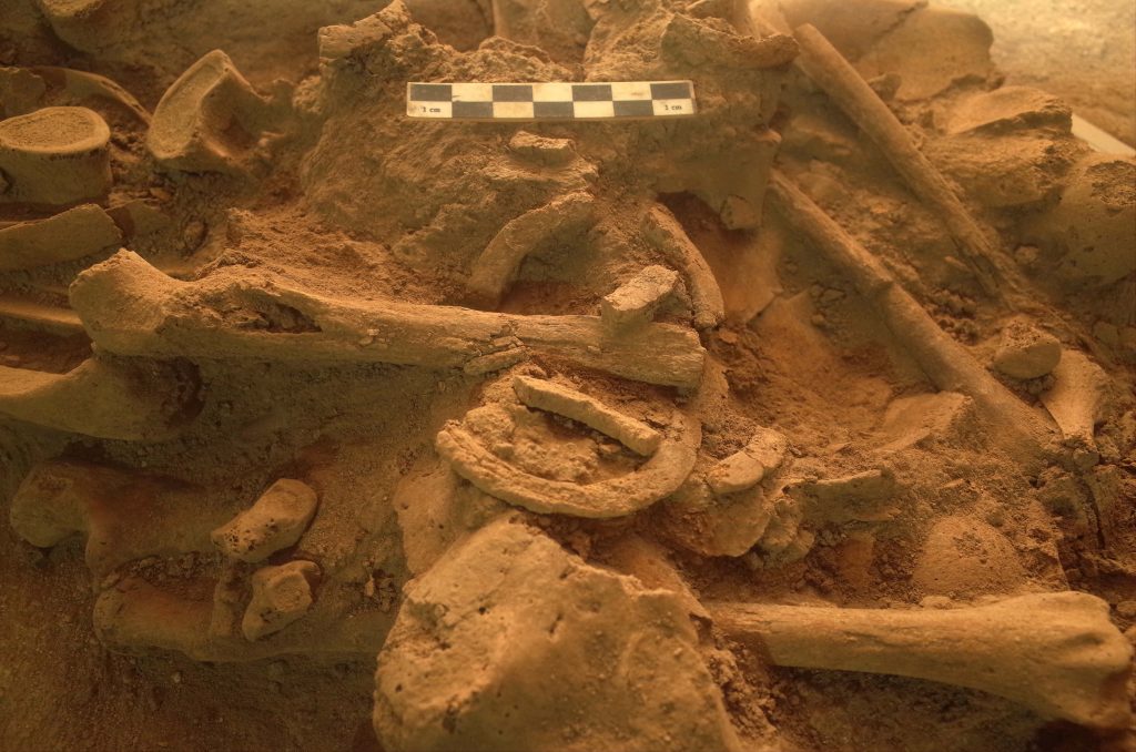
Documentation is the bread and butter of archaeological research. Archaeologists are daily committed to documenting everything: sites formation processes, dwellings, funerary remains, and above all the various products of material culture.

Any method of documentation, from the most essential and traditional (i.e., technical drawing of archaeological strata and finds) to the most elaborated (i.e., image-based 3D-modelling of artefacts, human remains, and sites) constitutes a fundamental step toward archaeological reconstruction. Documentation mainly serves the archaeologist to record and understand the material remains, settlement and funerary features identified during the archaeological excavation and to leave a trace of it. Also, through documentation, a preliminary process of interpretation and critical reading of the data is carried out. Furthermore, the system we adopt to document and classify archaeological data is not unbiased, rather it already implies a methodological choice and a specific scholarly interpretative approach.

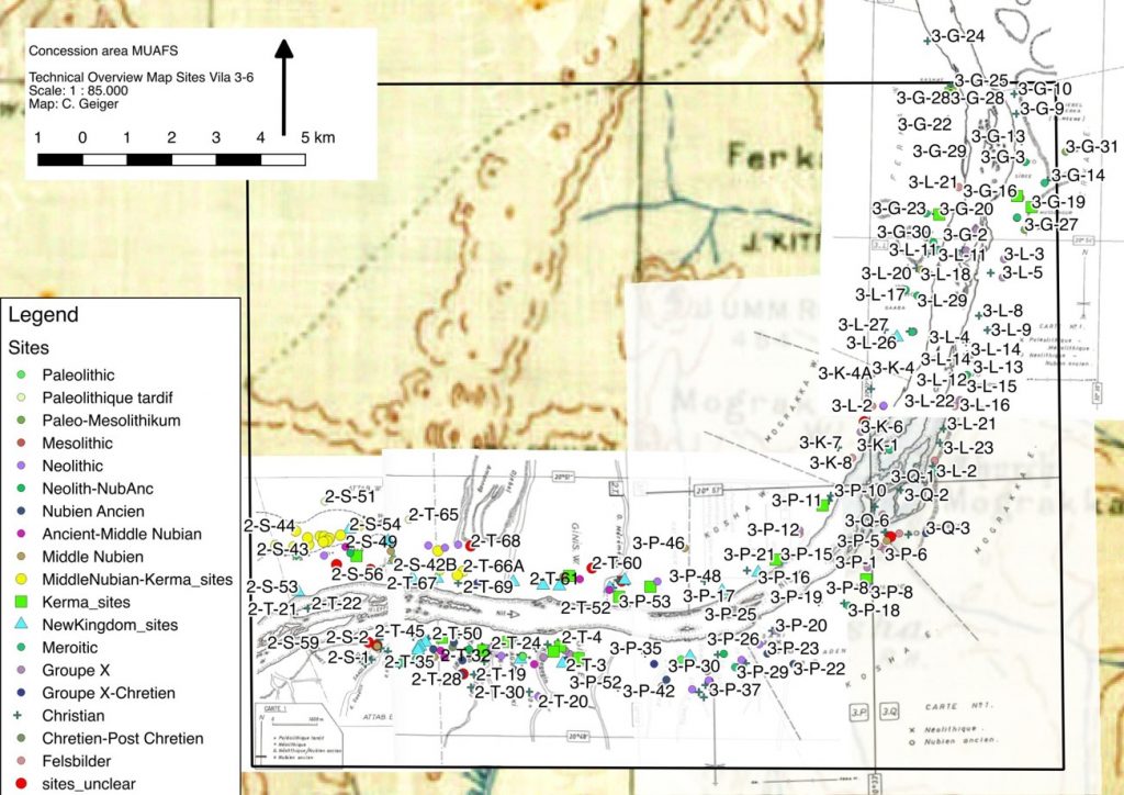
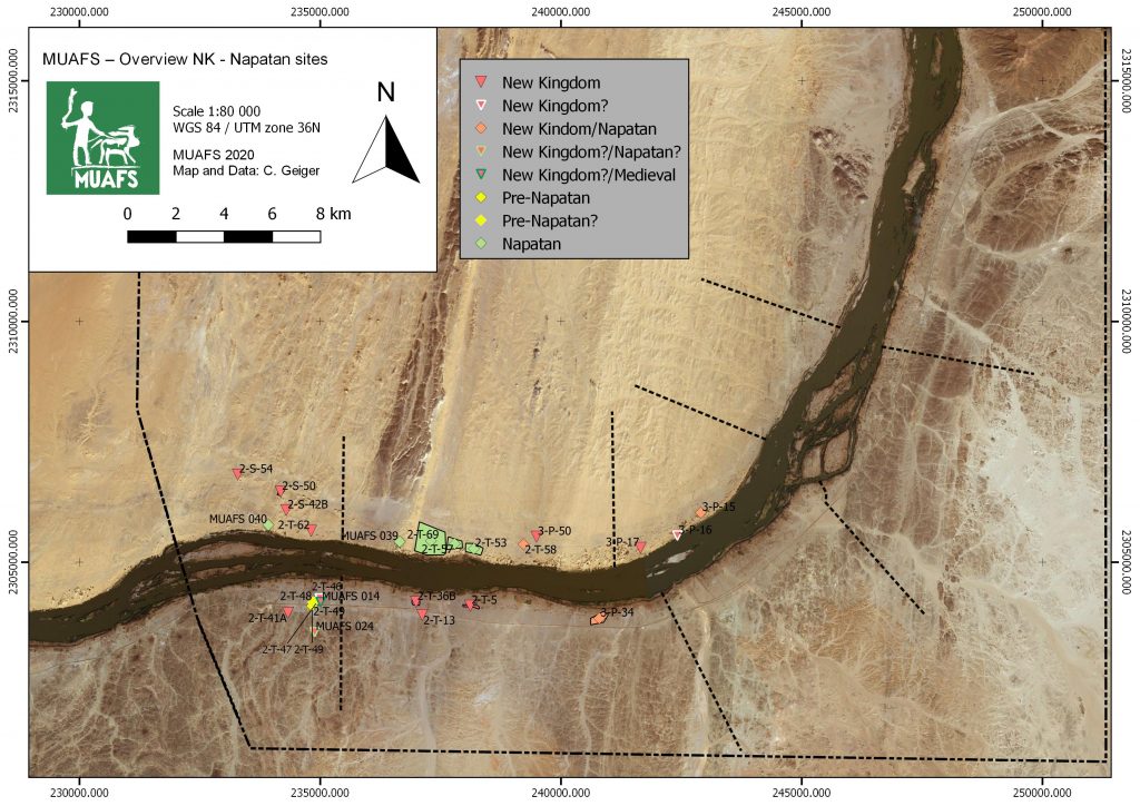
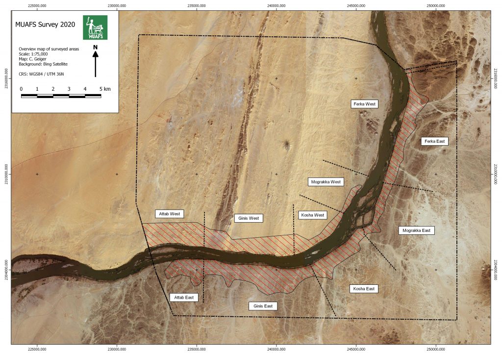
As responsible, within the Work Package 3 of the DiverseNile project, for the technological and compositional analyses of the ceramic materials, I want to outline the method I use for the petrographic classification of the ceramic samples which we are going to analyse from the new concession area in the Attab to Ferka region and from our reference collections (e.g., the AcrossBorders ceramic samples from Sai Island; the New Kingdom/Kerma-Dukki Gel pottery samples; see also D’Ercole and Sterba 2018).

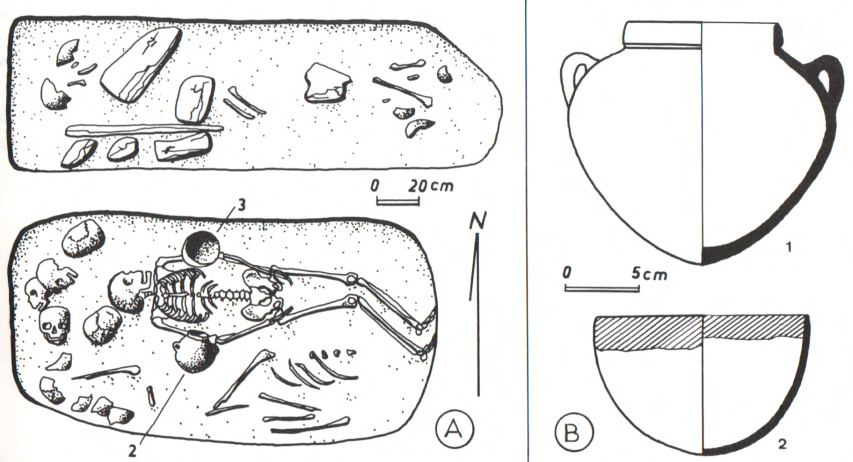
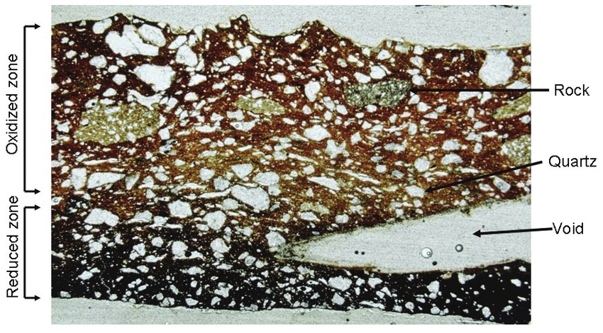
Generally speaking, petrography, via optical microscopy (OM), is a well-established procedure employed to examine ceramic objects and identify the source of clay raw materials and tempers used to manufacture the vessels (Fig. 1). This technique allows answering to crucial archaeological questions on pottery provenance and technology.

Figure 1. Example of ceramic thin section illustrating some common features documented for petrographic analysis. Adapted from Smith 2008: 74, Fig. 6.1.

In Sudanese archaeology, the interest in provenance and technological studies on pottery started approx. 50 years ago. In 1972, Nordström, referring to the work of Anna Shepard (1956), produced a systematic publication on early Nubian ceramics from the region of Abka-Wadi Halfa and defined the term fabric meaning the set of the compositional and anthropogenic characteristics of the ceramic material that could be determined by microscopic observation and comprised both the composition of the groundmass (or clay matrix) and non-plastic inclusions plus the potter’s technological choices adopted to make the vessel.

For the study of the ceramic material of our DiverseNile project I have designed a specific petrographic layout within the Filemaker database of the ceramic samples (Fig. 2).

Figure 2. Layout of the petrographic database designed for the DiverseNile project.

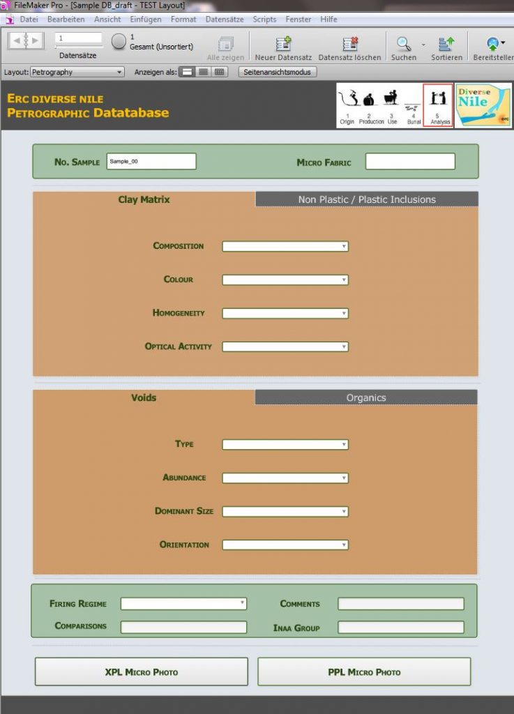
The petrographic layout includes information on the archaeological provenance and dating of the samples. It also correlates the micro fabric or petrographic group to the macroscopic evidence, that is the visual description, shape, function, and macro ware of the ceramic specimens. The consecutive entries inform on a) the groundmass or clay matrix of the sample (i.e., colour, homogeneity and optical activity); b) non-plastic inclusions (i.e., sorting, dominant grain size, maximum grain size, abundance, and mineral composition); c) plastic inclusions (i.e., clay pellets, argillaceous rock fragments etc.); d) porosity (i.e., voids abundance, type, dominant size, iso-orientation); e) organics (i.e., abundance, type, dominant size). The database also notifies on the firing regime of the ceramic sample (i.e., oxidised, reduced, reduced with narrow ox margins, dark core due to insufficient ox, oxidised to reduced). Finally, a graphic field incorporates the microscopic photos of the thin section taken under both cross-polarised (XPL) and plane polarised (PPL) light. Comments, possible comparison with other samples, and a link to the iNAA compositional groups are included as further relevant information.

The purpose of this database is to simplify the data entry of the petrographic evidence and to standardize it according to an easy-to-use, flexible, and consistent classificatory system that embraces the main information on the composition and technology of production of the ceramic data (see among others Quinn 2013).

At a subsequent step, this information will be intertwined with the results obtained from the other laboratory analyses and eventually with the archaeological data to provide a further analytical and interpretive tool for understanding the diversity and complexity of the material culture of the human groups living in the periphery of the Egyptian towns in Sudanese Nubia.

References

D’Ercole, G. and Sterba, J. H. 2018. From macro wares to micro fabrics and INAA compositional groups: the Pottery Corpus of the New Kingdom town on Sai Island (northern Sudan), 171–183, in: J. Budka and J. Auenmüller (eds.), From Microcosm to Macrocosm: Individual households and cities in Ancient Egypt and Nubia. Leiden.

Nordström, H. – Å 1972. Neolithic and A-Group sites. Uppsala, Scandinavian University.

Quinn, P. S. 2013. Ceramic Petrography: The Interpretation of Archaeological Pottery & Related Artefacts in Thin Section. Oxford, Archaeopress.

Shepard, A. O. 1956. Ceramics for the Archaeologist. Washington, DC: Carnegie Institution of Washington.

Smith, M. S. 2008. Petrography, Chapter 6, 73-107, in: J. M. Herbert, T. E. Mc Reynold (eds.), Woodland Pottery Sourcing in the Carolina Sandhills. Research Report No. 29, Research Laboratories of Archaeology, University of North Carolina at Chapel Hill.

Working on cultural diversity in Upper Nubia during the lockdown

These are challenging times – for everybody, for many groups more than others (just think of the heroes in hospitals, schools, kindergarten and supermarkets as well as many other places and the awful situation for everybody involved in gastronomy, tourism and culture). We as archaeologists are more or less well prepared for doing much of our work from home. Spending weeks and moths per year in the field, often stuck on an island somewhere, we are also used to a certain kind of isolation.

However, there are of course real problematic issues for us we are currently facing. First of all, of course going to the field in Sudan and Egypt – nothing that is possible at the moment and also planning our next season in the MUAFS concession is still extremely difficult because of the pandemic. Second, our teaching activities are restricted to online formats. Whereas this works without problems for lecture classes and seminars, our planned block seminar “Introduction to field archaeology” where we wanted to have various practical training for our participants would need to be completely revised as an online format. We have postponed it for now, hoping that it might be possible in March – I remain skeptical (or realistic?) since the extension of the lockdown in Munich is very likely, but let’s wait and see. Third, working at home and taking shifts in working in the office to secure isolation and limited risks for everybody is currently without alternative, but I miss having the complete team present and exchanging in a casual way.

Well – as archaeologists we are trained to be patient, and all will be better somewhen!

For now, I wanted to give a small update on our work progress. Everybody of the team is busy with several work tasks within the work packages – much efforts are currently spent by Giulia and Veronica on databases, by Jessica on enlarging our digital library and by Cajetan on various aspects of remote sensing. Rennan was busy with his PhD viva at Cambridge which he passed very successfully and now continues with collecting data useful to approach the mortuary archaeology of the MUAFS concession.

It was very silent from my side as PI and this with good reasons – it is the end of the teaching term, there’s a lot of administration keeping me busy and most importantly: I tried to finish a monograph about Tomb 26 on Sai Island in the last months. This process has taken quite some time and actually benefitted from the lockdown and that I was unable to leave Europe over the winter. This book is now almost ready and I could easy repeat what I had written in 2018 about the merits and flaws of preparing archaeological publications, especially about crazy working hours and panic attacks. And about the feeling of being overwhelmed when you know exactly that the really important things in life are neglected but you can’t help it – partner, family, friends and pets suffer and need to be very patient and supportive (or bribed in the case of animals). Friends and family got used to my slightly bizarre answers on the phone “yes, all is fine, I am still in my tomb, can we speak later?” and for this I am very grateful! Interestingly, there was not much difference between the last months in lockdown and the final book preparation period back in 2018. The results of isolation are just the same, with more silence in the office and maybe with the slight difference that I could not meet friends now, even if I could spare the time.

For the DiverseNile project, preparing the AcrossBorders publications is hugely relevant. There are so many aspects we will be able to compare with sites in our new concession which are after all located in the ‘periphery’ of Sai Island. Tomb 26 is one of the Egyptian style pyramid tombs on Sai where the local elite was buried. We had more than 36 burials in this monument and we are now able to reconstruct in detail the life history of the tomb and its users. Although the burial assemblages like the one of Khnummose follow Egyptian standards, there are also certain local markers and individual concepts which I describe in the forthcoming book. We assume that none of the users of Tomb 26 was actually coming from Egypt, all of them are belonging to the local elite with indigenous roots. Interestingly, we also have some Nubian features, especially traceable by the choice of ceramics and bodily adornment.

The probably best example is a young female who was buried with an ivory bracelet in Tomb 26 (Fig. 1). This bracelet was badly damaged and broken, but its find position over the ulna of the individual allowed a clear interpretation. Similar bracelets are known from several New Kingdom sites in Nubia (e.g. Buhen, Mirgissa and Fadrus) and can be regarded as typical ‘Nubian’.

In situ position of ivory bracelet in Tomb 26 on Sai (photo: J. Budka).

Overall, Tomb 26 on Sai Island illustrates as a case study the potential of investigating the variability of funerary practices within a common repertoire of burial customs adopted from Egyptian standards as being rooted in distinct social practices. One of the main tasks for the near future within the framework of the DiverseNile project is, therefore, to determine the degree of diversity not only in elite contexts such as the pyramid cemetery on Sai but also in social groups not belonging to the elite of New Kingdom Nubia in order to achieve a more comprehensive picture of past communities in the Middle Nile region. Our cemeteries in the Attab to Ferka region will allow us to make here considerable progress in the next years, especially because of our joint approach using both funerary and settlement records to reconstruct past communities.

Anniversary of a new challenge

The time between Xmas and New Year is often a kind of transition, for many a moment to pause, but for others also a super stressful time in which all kinds of things have to be finished and loads of papers are sitting on one’s desk because one deliberately waited for this “break” between the holidays…

Well, I do not want to go into details, but my current work in home office is far from being relaxed. Nevertheless, it seems adequate to pause for a moment and remember what was achieved in the last few years.

Today one week ago, I gave the first DiverseNile Xmas lecture – this zoom lecture was meant as a kind of “Thank you” to all my friends, colleagues and collaborators who supported me in the last decades.

I tried to outline the most important waypoints leading to the new project in the region between Attab and Ferka, taking my visits and research in the cataract areas as case studies, starting of course with my participation in the Elephantine project.

From the First, to the Third, Fourth and Second Cataract.

Today two years ago, I was leaving Khartoum to go north and start work in my new concession between Attab and Ferka, the first field season of the MUAFS project started. Our very promising results of this first season served as the basis for the successful acquisition of the present ERC DiverseNile project – thus really a day to remember!

Preparing my lecture for last week, I reassessed my old documentation of rock inscriptions at Tombos, but especially of the Humboldt University Nubian Expedition at the Fourth Cataract as part of the Merowe Dam Archaeological Salvage Project. I will never forget the moment when we first entered our concession area in 2004 coming from the desert and looking on a barren, yet infinitely beautiful cataract landscape.

The three years of fieldwork in the area of Kirbekan were a great challenge, but this work has shaped me and taught me so much about archaeology and surveying. We had a great variety of funerary monuments and for me besides rock art the most interesting sites were tombs of the Napatan era and others associated with the Kerma culture. The discovery of Kerma remains/a local Kerma horizon was among the most impressive outcomes of the entire Merowe Dam Archaeological Salvage Project! And fits perfectly to our current investigations in the Attab to Ferka region.

My visits to the Batn el-Hagar, the Kajbar cataract and of course Sai Island will never be forgotten. Sudan is such an impressive country with stunning landscapes and much more!

Without the years of the AcrossBorders project on Sai Island, my current research focus on remains from the Egyptian colonial era in the Attab to Ferka region with an emphasis on cultural diversity and the materialisation of cultural encounters would not be possible. Thus, many thanks again for all who supported me – there are exciting years ahead of us, stay tuned for new results from the MUAFS concession!

On the footsteps of Vila and the archaeology of monumental surveys in northern Sudan

Every archaeologist knows that what we write about the past is mediated by present-day questions, expectations and challenges, but also state-of-the-art documentation techniques. Archaeologists don’t simply reconstruct what happened back in the day. Instead, archaeological and historical narratives are essentially modern constructions that can either be repaired or demolished as scholarship moves forward. Archaeological research is also mediated by complex site and object biographies that span thousands of years; e.g., in our case, from the Neolithic to monumental surveys carried out in northern Sudan in the mid-20th century.

To understand tombs, burials and mortuary objects in the region from Attab to Ferka we need to understand the impact of André Vila’s work in the region, the epistemological framework from which he was reporting and his methodology. How Vila’s work materialise in the landscape directly affect the questions we ask and the methodologies we apply today. Not surprisingly, archaeologists in Sudan usually deal with traces left by earlier archaeologists at various sites, and retracing their steps becomes a fundamental aspect of accessing the past through remaining material culture (e.g., Howley 2018: 86-87).

Vila’s survey can be seen as part of a long tradition of large-scale surveys going back to the first Archaeological Survey of Nubia (see Adams 2007). From Dal (the southern limit of Lake Nubia) to Nilwatti Island, Vila identified 462 sites of which 219 sites are within the MUAFS concession (figure 1). These sites were attributed to cultural units, e.g., Kerma, Christian etc. Even though Vila noted that various sites belonged to one or more cultural units, today archaeologists approach those ‘units’ more fluidly, especially in situations of cultural exchanges, which is especially true for Kerma and New Kingdom sites. On the one hand, revisiting sites surveyed and reported in the 1960s and ’70s requires us to contextualise archaeology to ‘deconstruct’ theoretical biases and ask different questions. On the other hand, Vila’s methodology determines the extent to which sites can be explored.

Figure 1: distribution of sites in the MUAFS/DiverseNile concession area (map: C. Geiger)

In terms of method, Vila’s survey aimed to keep disturbance to sites to a minimum. Test excavations and sampling followed rigid guidelines and excavations were only carried out when cultural affiliations couldn’t be distinguished otherwise, e.g., based on surface finds. Cemeteries were approached in a slightly different way. Cemeteries were usually cleared to determine their extent and number of graves at each site. A few graves were fully excavated and recorded, as well as ‘peculiar’ collective burials (figure 2).

Figure 2: Bagagin Farki, Ginis East. “Egyptian” New Kingdom pit burial containing an individual deposited in extended position together with sherds from two pots and the remains of other six individuals (Vila 1977, Vol. 5: 47)

In Work Package 2, I am responsible, among other things, for reassessing the material from such graves. For example, comparison of items from graves in our concession area with objects from other sites allows us to shed new light onto different roles performed by the same types of objects in different contexts (Lemos 2020). Scientific analysis of pottery also allows us to explore the (potentially) alternative role of objects in rituals (stay tune to Giulia D’Ercole’s blog!). I am currently collaborating with Kate Fulcher from the British Museum on the topic of mortuary rituals in New Kingdom Nubia based on scientific analysis of artefacts (see Fulcher and Budka 2020 for examples of such approaches).

Working with previously excavated material culture poses several theoretical and methodological challenges, mostly related to the lack of information provided by earlier excavation reports and the problematical categories used to classify things. However, revisiting the burials excavated by Vila holds an immense potential for us to ask different questions within larger-scale perspectives on burial communities, the role of (foreign) objects in the constitution of (local) social relations and identity formation strategies. Comparative approaches to sites and material culture allow us to understand different social realities within Nubia, challenging previous homogenising perspectives on cultural interactions focusing on elite centres. Revisiting sites also holds great potential to unveil things under new theoretical perspectives and using state-of-the-art documentation techniques. This is especially the case because disturbance to sites was limited during Vila’s survey, although looting poses an additional challenge to new fieldwork in our concession area.

Ultimately, researching burials and other sites in our concession area and excavating sites firstly worked by Vila presupposes a deep knowledge of the data sets produced by him, what was ignored/discarded, what was considered worth investigating etc. Previous ways of excavating, identifying and reporting sites also determine the extent to which we can revisit them through excavation and comparative analysis.

References

Adams, W. Y. 2007. A Century of Archaeological Salvage, 1907-2007. Sudan and & Nubia 11: 48-56.

Fulcher, K. and J. Budka. 2020. Pigments, incense, and bitumen from the New Kingdom town and cemetery on SaiIsland in Nubia. Journal of Archaeological Science https://doi.org/10.1016/j.jasrep.2020.102550.

Howley, K. 2018. Return to Taharqo’s Temple at Sanam: the inaugural field season of the Sanam Temple Project. Sudan & Nubia 22: 81-88.

Lemos, R. 2020. Material Culture and Colonization in Ancient Nubia: Evidence from the New Kingdom Cemeteries. Encyclopedia of Global Archaeology, ed. C. Smith. https://doi.org/10.1007/978-3-319-51726-1.

Vila, A. 1977. La prospection archéologique de la Vallée du Nil, au Sud de la Cataracte de Dal (Nubie Sudanaise). Fascicule 5: Le district de Ginis, Est et Ouest. Paris: CNRS.

On the tracks of ancient cultures: Archaeological Geophysics

As a team member of the first MUAFS season 2018/2019 responsible for magnetic investigations I would like to introduce the geophysical methods used for archaeological purposes. These methods will also be highly relevant for the DiverseNile project.

In the last decades, geophysics became a substantial part of archaeological projects. Depending on several factors, the most suitable geophysical method is chosen: the environment (desert, steppe, swampland etc.), the archaeological period and the used archaeological materials (stone, mudbrick etc.), but also the questioning (settlement layout and extension, cemetery detection etc.).  Additionally, the decision is influenced by available time, financial means and sometimes the season.

Still the fastest and most effective geophysical method in archaeology is magnetometry. It provides getting an overview of a site as well as its environment, extension and layout. Magnetic prospecting enables us to distinguish between settlement and burial sites, their structure, special buildings, open areas, as well as fortifications. Depending on the chosen sensors, we can learn more about the geology and environment and their changes over time. Accompanying measurements of magnetic susceptibility deliver information about magnetic properties of scattered objects and building materials as well as archaeological sediments and can be used in archaeological excavations as well.

Magnetic gradient investigations in Ginis 2019, site GiE 001 (Photo: Giulia D’Ercole).

But how does it work? Magnetometers are recording the intensity of the earth magnetic field with high-resolution. Nowadays, the earth magnetic field in the Attab to Ferka region has an intensity of around 39.400 Nanotesla (nT). With sensitive total field magnetometers, magnetic anomalies of less than 1 nT can be detected during archaeo-geophysical surveys, displaying even archaeological features like mudbrick walls or palisades.

Magnetic investigations benefit from varying magnetic properties of archaeological soils and sediments as well as materials. Every human activity regarding the surface is detectable because of different magnetic response. For example, digging a ditch, building a wall or using a kiln is changing or disturbing the actual earth magnetic field. What else can be detected? Architecture, streets, canals and riverbeds, ditches, pits and graves can be revealed just as palisades, posts and fire installations. Additionally, more information about geological and environmental conditions can be collected using magnetometry, e. g. paleo channels or former wadis.

For detecting stone architecture and for example voids, resistivity (areal or profile) and Ground Penetrating Radar (GPR) methods are applied, partly in addition to magnetic investigations. While magnetometry gives an overview about buried features beneath the surface in a ‘timeless picture’, GPR and ERT (Electrical Resistivity Tomography) provide more information about the depth and preserved height of the features. Of course, more than one geophysical method can be applied to get a comprehensive dataset for more complete interpretation of the results. Combined with archaeological work – survey and excavation – we can increase our knowledge and understanding of physical properties of archaeological and geological features as well as improve our interpretation.

Geophysical prospecting was originally developed for military purposes to detect submarine boats, aircrafts or gun emplacements. Furthermore, natural and especially mineral resources can be located. Geophysical methods and first of all magnetometry are used in archaeology since the late 1950s, when Martin Aitken detected Roman kilns in the UK. In Sudan, magnetometry is used since the late 1960s when Albert Hesse started investigations at Mirgissa in Lower Nubia. Since then, instruments as well as software programs for data collecting, processing and imaging have been developed and improved and offer detailed mapping of sites. First, geophysical prospecting can be applied fast, nondestructive and comprehensive. For magnetic prospection there is a variety of configurations to use, from handheld one/two-sensor instruments to motorized and multisensory systems but also different types of sensors. Through geographic information systems (GIS) geophysical investigations are benefiting from integrating high-resolution satellite images, drone images and models, survey and excavation data for a comprehensive interpretation of results.

After collecting magnetic data in the field, the files are downloaded and processed to get an idea of the first results. With that the field measurement proceeding can be adjusted as well as excavation trenches can be chosen. The detailed processing and analyzing of the collected field data are conducted back home on the desk.

References

Campana, Stefano; Piro, Salvatore (eds.) (2009): Seeing the Unseen. Geophysics and Landscape Archaeology. London: Taylor & Francis.

Dalan, R. (2017): Susceptiblity. In: Allan S. Gilbert, Paul Goldberg, Vance T. Holliday, Rolfe D. Mandel and Robert Siegmund Sternberg (eds.): Encyclopedia of Geoarchaeology. Dordrecht: Springer Reference (Encyclopedia of Earth Sciences Series), 939–944.

Fassbinder, Jörg W. E. (2017): Magnetometry for Archaeology. In: Allan S. Gilbert, Paul Goldberg, Vance T. Holliday, Rolfe D. Mandel and Robert Siegmund Sternberg (eds.): Encyclopedia of Geoarchaeology. Dordrecht: Springer Reference (Encyclopedia of Earth Sciences Series), 499–514.

Herbich, Tomasz (2019): Efficiency of the magnetic method in surveying desert sites in Egypt and Sudan: Case studies. In: Raffaele Persico, Salvatore Piro and Neil Linford (eds.): Innovation in Near-Surface Geophysics. Instrumentation, Application, and Data Processing Methods. First edition. Amsterdam, Oxford, Cambridge: Elsevier, 195–251.

Schmidt, Armin; Linford, Paul; Linford, Neil; David, Andrew; Gaffney, Chris; Sarris, Apostolos; Fassbinder, Jörg (2015): EAC Guidelines for the Use of Geophysics in Archaeology. Questions to Ask and Points to Consider. Namur: Europae Archaeologia Consilium (EAC Guidelines, 2).

Investigating the variability of domestic architecture in the Attab to Ferka region (MUAFS concession area)

After the recent blog posts by my colleagues Rennan Lemos and Giulia D’Ercole presenting their tasks within Work Package 2 and Work Package 3 I am not only happy to introduce Work Package 1: The variability of domestic architecture in the Attab to Ferka region I am – together with our PI Julia Budka – responsible for, but also to write my first blog entry as a member of the ERC Consolidator Grant project DiverseNile. This especially, since I already could join the previous ERC Starting Grant project AcrossBorders of Julia Budka for its last year at the end of 2017, leaving Berlin and moving to Munich, which – as a Tyrolean – felt a bit like coming home.

My first contact with Sudan, which I immediately fell in love with, while working in Hamadab/Meroe and Musawwarat es-Sufra, was very long ago in 2003. But also my first visit to the region between the Second and Third Cataract – and here specifically to Sai Island with its impressive New Kingdom town – dates some years back to 2012.

At Sai Island, especially by the AcrossBorders project or at the neighbouring town Amara West (Spencer et al. 2017), the research of the recent years concerning the manifold relations between the Egyptians and the Nubians in the Middle Nile already moved towards a more differentiated approach with implementing the concept of ‘cultural entanglement’ (see van Pelt 2013 with references). The focus of work at sites like Sai and Amara being administrative centres in New Kingdom Nubia was necessarily set on the official and elite sphere.

The DiverseNile project investigating the Attab to Ferka region now goes a step further aiming to throw light on the peripheries still very much standing in the shadows of the powerful urban sites. Shifting the focus towards the hinterland not only broadens our horizon filling the still significant voids of research in this region of the Nile valley but very much promises to give a new and deeper insight in the cultural diversity of people living in the hinterland of towns, their interactions and possible more autonomous living situations – as these aspects become archaeologically more visible aside official power throughout the rich cultural history of Nubia.

In this regard WP 1 aims to contribute to a better understanding of the occupants of the Attab to Ferka region, their cultural identities and interactions, their social structures or complexity through investigating the diverse settlement sites, their variability and development and thus their spatial and temporal frame. Concerning the latter our focus lies on Bronze Age Nubia, a term introduced by our PI reflecting the need to have a more differentiated look at the so far used categories ‘Nubian’ or ‘Egyptian’ during the Kerma and the Egyptian Second Intermediate and New Kingdom Periods in Nubia and thus an era with multiple upheavals. This need became also clear studying the previously classifications attributed to the diverse archaeological remains in this part of the Middle Nile valley.

In this respect the region of our interest was previously and firstly surveyed by the Sudan Antiquities Service together with the French Archaeological Research Unit in the 1970ies directed by A. Vila and resulting in several Volumes. These works serve as very important input for our research, as Vila and his team impressively discovered and documented 219 sites from Palaeolithic to Medieval times. Among these, sites qualified by Vila as Kerma and New Kingdom remains were represented both at around 7% on the right and with a larger number at 12.4% resp. 16.9% on the left riverbanks, the latter consisting predominantly of settlement sites.

Kerma sites in the Attab to Ferka region identified by the MUAFS project (status: 2020)

Among all of the sites listed by Vila a total of 138 sites could be successfully re-identified during our two MUAFS seasons in 2018/2019 and at the beginning of this year, shortly before Covid-19 became the new reality (for further details see the online reports as well as Budka 2019). As an fascinating example for an Egyptian New Kingdom domestic site comprising evidence for Kerma presence too, GiE 001 (Vila’s site NF-36-M/2-T-36B), can be emphasized here, where a test excavation was started in 2020, which we will hopefully further pursue next year.

Distribution of New Kingdom, Pre-Napatan and Napatan sites in the MUAFS concession (status: 2020)

Although Covid-19 has restricted us to office work, it has not limited us to carry out our research or staying in contact with our Sudanese colleagues and friends. Re-planning rather is giving us the possibility not only to evaluate the already gained data and information but also to engage with the topic in depth. In this regard I am currently not only further screening sites of our interest indicated by Vila, analysing his approach and state of documentation, but also their distribution within our concession area. Concerning the latter the examination of similar situations of periphery within frontier zones like for example the Third Cataract (Edwards 2012) and a deeper study of other rural Kerma villages like Gism el-Arba (Gratien 2003) yields a very fruitful input for our questionings in many ways. As I dealt a lot with Kushite sacral architecture in the last years doing my PhD, I am especially happy to explore architectural remains aside of the official sphere telling a lot of different and lesser known stories. In this regard – as my next blog entry will address Kerma types of domestic architecture and building techniques – keep reading here in our space!

References

Budka, J. 2019 (with contributions by G. D’Ercole, C. Geiger, V. Hinterhuber and M. Scheiblecker). Towards Middle Nile Biographies: the Munich University Attab to Ferka Survey Project 2018/2019. Sudan & Nubia 23, 13–26.

Edwards, D. N. 2012. ‘The Third-Second Millennia BC. Kerma and New Kingdom Settlements’, in A. Osman and D. N. Edwards (eds), Archaeology of a Nubian frontier. Survey on the Nile Third Cataract, Sudan. Leicester, 59–87.

Gratien, B., S. Marchi, O. Thuriot, and J.-M. Willot 2003. ‘Gism el- Arba, habitat 2. Rapport préliminaire sur un centre de stockage Kerma au bord du Nil’. Cahiers de Recherches de l’Institut de Papyrologie et d’Égyptologie de Lille 23, 29–43.

Spencer, N., Stevens, A. and Binder, M. 2017. Introduction: History and historiography of a colonial entanglement, and the shaping of new archaeologies for Nubia in the New Kingdom, 1‒61, in: N. Spencer, A. Stevens and M. Binder (eds.), Nubia in the New Kingdom. Lived Experience, Pharaonic Control and Indigenous Traditions. British Museum Publications on Egypt and Sudan 3. Leuven.

Van Pelt, W.P. 2013. Revising Egypto-Nubian Relations in New Kingdom Lower Nubia: From Egyptianization to Cultural Entanglement. Cambridge Archaeological Journal 23.3, 523‒550.

Mortuary archaeology in the area from Attab to Ferka (MUAFS concession area)

With my appointment as the newest member of the DiverseNile team, it’s now time to present Work Package 2: The Variability of Funerary Monuments in the Region from Attab to Ferka, Northern Sudan.

Figure 1: Map of MUAFS concession with overview of surveyed areas (C. Geiger).

As responsible for Work Package 2, I will investigate, with PI Julia Budka, all aspects of mortuary sites within the MUAFS concession area (figure 1). The area from Attab to Ferka was firstly surveyed by André Vila within a larger survey from Dal to Missiminia. The results of Vila’s survey were published by the French CNRS in 15 volumes, which describe numerous sites located in the area­­­­­. Volumes 3 to 6 focus on the MUAFS concession in the region from Attab to Ferka.

Vila identified a series of funerary sites between Attab and Ferka, which I will explore in my research within the DiverseNile team. The aim is to understand the materialisation of cultural diversity through tomb architecture, burial customs and goods, focusing on the Bronze Age, which in our concession area comprises the Kerma, Egyptian New Kingdom and Napatan periods.

The 2018/19 and 2020 seasons of MUAFS survey re-identified and documented various burials sites previously listed by Vila, some of which were extensively plundered in recent times (Budka 2019; see also our online reports). Two cemeteries at Ginis East seem to be especially relevant for future excavation. GiE002 (Vila site 2-T-13) and GiE003 (Vila site 2-T-13) date to the Kerma Period and Egyptian New Kingdom, respectively. Kerma cemeteries usually comprise tumuli burials, while New Kingdom sites include shaft tombs with no preserved superstructure. Magnetometry was carried out at both sites in 2019 and will be used to further assess the archaeological potential of the cemeteries to plan future excavations. An additional survey is also planned for the next season, which will hopefully reveal more potentially relevant cemeteries or isolated tombs.

Besides new excavations, a large part of research on mortuary sites in our concession area consists of revisiting publications, archives and material culture previously excavated and now in museums. I’m currently developing a research strategy that will explore both avenues. My PhD experience demonstrated the huge potential of revisiting old excavation reports and archival material (see, for example, Edwards 2020), as well as museum collections from a fresh theoretical perspective.

In general, the DiverseNile project focuses on shifting conceptualisations and experiences of ‘centres’ and ‘peripheries’. My previous research stresses the contextual role performed by foreign objects in local contexts in New Kingdom cemeteries in Nubia. I argue that foreign, Egyptian-style objects could perform alternative, local tasks other than materialising Egyptian colonisation through objects in Nubian contexts (Lemos 2020). DiverseNile Work Package 2 will combine both general theoretical perspectives to unveil cultural diversity in contexts previously thought to express homogenisation only.

I am also particularly interested in refining our understanding of New Kingdom chronology in Nubia. So far, Egyptocentric approaches have mainly accepted that the same dates used to understand Egyptian history apply to Nubian colonial contexts. In my PhD thesis, I discuss the use of alternative terminology, based on local Nubian experiences of colonisation, instead of landmarks of Egyptian political history. DiverseNile has been adopting ‘Bronze Age Nubia’ as a working alternative. PI Julia Budka and I will be closely working on this topic, and I hope that new excavations will provide us with more refined dates than those usually extracted from typological approaches to sites and material culture. This would be especially relevant for the end of the New Kingdom colonial period/pre-Napatan Period, which is still poorly understood (e.g., Thill 2007; Binder 2011).

Stay tuned to this space for updates regarding my work on mortuary sites and material culture in Attab-Ferka!

References

Binder, M. 2011. The 10th-9th century BC – New Evidence from Cemetery C of Amara West. Sudan & Nubia 15: 39-53.

Budka, J. 2019 (with contributions by G. D’Ercole, C. Geiger, V. Hinterhuber and M. Scheiblecker). Towards Middle Nile Biographies: the Munich University Attab to Ferka Survey Project 2018/2019. Sudan & Nubia 23: 13-26.

Edwards, D. ed. 2020. The Archaeological Survey of Sudanese Nubia, 1963-1969. The Pharaonic Sites. Oxford: Archaeopress.

Lemos, R. 2020. Material Culture and Colonization in Ancient Nubia: Evidence from the New Kingdom Cemeteries. In Encyclopedia of Global Archaeology, ed. C. Smith. New York: Springer. https://doi.org/10.1007/978-3-319-51726-1_3307-1

Thill, F. 2007. Les réoccupations “(pré)napatéennes” dans le cimetière égyptien 8B5/SAC5 de Sai. In Mélanges offerts à Francis Geus, ed. B. Gratien. CRIPEL 26: 353–369.

Back to school – or: DiverseNile after the summer break

Munich is very busy again, the quiet days of the summer break in the city are gone, the parks are crowded again, school vacations are almost finished and a new school year will start next week.

The MUAFS project and DiverseNile had just a very short break in August, everything was quite packed due to the extended corona term at LMU and some appointments including a very pleasant one in Vienna: my family lecture about archaeology in Egypt and Sudan! This lecture was part of activities by the Austrian Academy of Sciences in the framework of the KinderUniOnline.

I tried to explain to kids in the age of 7-12 years why I am personally still fascinated by ancient Egypt and Sudan. I talked about the numerous finds we unearth and can use to try to reconstruct daily life activities and more. I highlighted some examples from the tomb of Ankh-Hor in Luxor and of course I talked about cooking pots, ceramics in general (and brought some sherds with me to show!) and the very promising remains in the Attab to Ferka region which still have so many open questions for us.

You can watch my lecture (in German) at youtube:

Let’s hope that some future archaeologists are inspired by the rich archaeological heritage in Egypt and Sudan!

The periphery of New Kingdom urban centres in the Middle Nile

My ERC project DiverseNile focuses on the Attab to Ferka region as a peripheral zone in the neighbourhood of Amara West and Sai Island. However, I do not apply the problematic core-periphery concept for our case study of the Bronze Age, but I have introduced the contact space biography approach.

This morning, I just read a very inspiring paper I found in a new open access journal: Federica Sulas and Innocent Pikirayi wrote about “From Centre-Periphery Models to Textured Urban Landscapes: Comparative Perspectives from Sub-Saharan Africa”.

They review the relations between ancient capital centres in Africa and their peripheries, using Aksum and Great Zimbabwe as case studies. They include a very good introduction about the history of research from central-place theory and world-system theory to network theories and stress that „archaeological research on centre–periphery relations has largely focused on the structure of integrated, regional economic systems“ (Sulas and Pikirayi 2020, 67). Like DiverseNile, they advocate to take the dynamics of interactions into account, the fluidity of what is considered “centre” and what “periphery”.

In Nubian studies and Egyptology, there is a considerable gap of work at sites in the periphery of major settlements (see Moeller 2016, 25). At present, despite of much progress on settlement patterns in Nubia during the New Kingdom (see e.g. Budka and Auenmüller 2018) we still know almost nothing about the surroundings of administrative centres set up by the Egyptians in the Middle Nile and the cultural processes within this periphery. The urban centres of this period in the Middle Nile are the Egyptian type towns Amara West, Sai, Soleb, Sesebi and Tombos and Kerma City as capital of the Nubian Kerma Kingdom. Very little rural settlements have been investigated up to now, creating a dearth of means to contextualise the central sites (Spencer et al. 2017: 42). Sites classified as ‘Egyptian’ apart from the main centres are almost unknown (Edwards 2012) and there are only two case studies for Kerma ‘provincial’ sites with Gism el-Arba (Gratien et al. 2003; 2008) and H25 near Kawa (Ross 2014).

If we want to understand the proper dynamics of Bronze Age Middle Nile, this bias between studies of urban centres and rural places in the so-called peripheries needs to be addressed. However, such a new study should avoid the problematic issues of a hierarchy of sites associated with the centre-periphery relations. Thus, DiverseNile intends to offer a new model focusing on the landscape and consequently human and non-human actors in a defined contact space.

Our new approach: beyond core and periphery

Within the DiverseNile project, we understand the Attab to Ferka area as a dynamic, fluid contact space shaped by diverse human and non-human actors. My main thesis is that we need to investigate cultural relations and coalitions between people on a regional level within the so-called periphery of the main urban centres in order to catch a more direct cultural footprint than what the elite sources and state built foundations can reveal. I expect that cultural refigurations reflected in material remains are partly less, partly more visible than in the centres shaped by elite authorities, where dynamic cultural developments are often disguised under an ‘official’ appearance. However, I completely agree with Sulas and Pikirayi that: “Peripheral settlements are always an integral part of the core, as these play a crucial part in enhancing the dynamics exhibited at the centre” (Sulas and Pikirayi 2020, 80). Thus, our new work in the Attab to Ferka region will allow us to contextualise the findings at sites like Amara West and Sai further.

There is still much work to do and data to assess, but I am positive that in the next few years, we will be able to propose a new understanding of ‘centres’ and ‘peripheries’ in Bronze Age Middle Nile (see already the stimulating article by Henriette Hafsaas-Tsakos 2009).

References

Budka, Julia and Auenmüller, Johannes 2018. Eds. From Microcosm to Macrocosm. Individual households and cities in Ancient Egypt and Nubia. Leiden.

Edwards, David N. 2012. The Third-Second Millennia BC. Kerma and New Kingdom Settlements, 59–87, in: A. Osman and D.N. Edwards (eds.), Archaeology of a Nubian frontier. Survey on the Nile Third Cataract, Sudan. Leicester.

Gratien, Brigitte et al. 2003. Gism el-Arba, habitat 2. Rapport préliminaire sur un centre de stockage Kerma au bord du Nil, Cahiers de Recherches de l’Institut de Papyrologie et d’Égyptologie de Lille 23, 29–43.

Gratien, Brigitte et al. 2008. Gism el-Arba – Habitat 2, Campagne 2005–2006, Kush 19 (2003–2008), 21–35.

Hafsaas-Tsakos, Henriette 2009. The Kingdom of Kush: An African Centre on the Periphery of the Bronze Age World System, Norwegian Archaeological Review 42, 50–70.

Moeller, Nadine 2016. The Archaeology of Urbanism in Ancient Egypt. From the Prehistoric Period to the End of the Middle Kingdom. Cambridge.

Ross, T.I. 2014. El-Eided Mohamadein (H25): A Kerma, New Kingdom and Napatan settlement on the Alfreda Nile, Sudan & Nubia 18, 58‒68.

Spencer, Neal et al. 2017. Introduction: History and historiography of a colonial entanglement, and the shaping of new archaeologies for Nubia in the New Kingdom, 1‒61, in: N. Spencer, A. Stevens and M. Binder (eds.), Nubia in the New Kingdom. Lived Experience, Pharaonic Control and Indigenous Traditions. British Museum Publications on Egypt and Sudan 3. Leuven.

Sulas, Federica and Pikirayi, Innocent 2020. From Centre-Periphery Models to Textured Urban Landscapes: Comparative Perspectives from Sub-Saharan Africa, Journal of Urban Archaeology 1, 67–83 https://www.brepolsonline.net/doi/epdf/10.1484/J.JUA.5.120910

Archaeological team building in times of covid-19

Walking through Munich in these warm and sunny days, one could think that nothing happened, that there is no worldwide pandemic. As an archaeologist working in Egypt and Sudan, this illusion seems completely unreal to me. I am still checking the covid-19 data from the two countries in the Lower and Middle Nile on a daily basis and news from friends and colleagues arrive via twitter, whatsapp and email. Since a few weeks, there are unfortunately also corona cases in the region of Abri, thus close to our MUAFS concession, and the situation in Luxor, Egypt, is far from being under control. Especially in view of the current travel warnings to Sudan and Egypt, I have cancelled the planned season in Luxor for the Ankh-Hor project. And we still have no idea when we can go back to the Attab to Ferka region – very thought-provoking times indeed and my thoughts are first of all with all Egyptians and Sudanese who are now facing major challenges which go far beyond health issues.

Well – with the Luxor field season cancelled and the Sudan field season on hold, my team is currently working on different tasks and we are especially focused on the analysis of our past seasons and on preparing publications. We still are working partly in home office and our monthly jour fixe meetings for the ERC DiverseNile project are run digitally via zoom.

With the summer term of LMU coming towards an end and the summer break approaching, I thought it would be beneficial for our team spirit to meet again in person – of course wearing masks and keeping the appropriate distance.

This weekend, we therefore had a very stimulating meeting focusing on digital archaeology. This is nothing brand-new for us – my former ERC AcrossBorder project used many computer-based tools such as spatial analysis, 3D modelling, image analysis etc. Our workflow in the field included a digital documentation system which was already introduced to the MUAFS project in 2020. It is based on a geodetical survey by a total station instrument and image-based 3D modelling via “Structure from Motion” (SfM). Because of the utilization of standard equipment already present on excavations (total station, digital camera and regular mobile computers) the system is robust and flexible. We employed it for three main tasks of various scales and contexts at Sai: 1) excavations in single-context surfaces, 2) excavations in subterranean rock-cut chambers, 3) kite aerial photography for establishing a digital landscape model of the area of interest.

Although we are very happy with our digital documentation system (of which we owe a lot to Martin Fera from Vienna), some work steps could be improved and especially Cajetan invested already much time in thinking about alternations and new solutions to improve the workflow. With our new project, we want to go a bit further, for example by using field-suitable mobile devices. And this is something where we now, due to covid-19, have much time to plan before the next field season.

Team meeting in times of covid-19.

During our team meeting this weekend, we discussed and tried several new tools and settings, especially our new pen tablets and displays. Patrizia has already great skills working with these tablets, first of all for the digitalization of drawings. But there are so many other possible applications! Patrizia showed us several apps and useful software and we already had some great ideas to incorporate these new tools into the workflow for our projects in both Egypt and Sudan.

DiverseNile is clearly on a new level using computer-based tools compared to AcrossBorders – timely of course, and also of much benefit not just for research, but also for teaching. The upcoming winter term at LMU will be again a digital term – with e-learning and online tools for safety reasons. We are quite well prepared, also for teaching our introduction to archaeological fieldwork via zoom and with mobile devices like tablets and smart phones – we will thus bring the latest developments in digital archaeology to our students.

Much in archaeology does, however, not only depend on the equipment but especially on the skills of the team – we will therefore continue with team building activities in these challenging times in order to be best prepared for the upcoming successful digs in Egypt and Sudan. All fingers and toes crossed that these digs will be possible soon!