This past season in Sudan, our drone program took flight (pun-intended) in more ways than one. We dedicated most of our efforts to flying programmed missions over large areas of the landscape mainly in Attab West, to collect data for the generation of Digital Elevation Models (DEMs) and orthophotos. In addition, we found time to make targeted flights of standing architecture for 3D modeling and visualization purposes. Digital recording of archaeological sites using the methods and principles of photogrammetry has immense implications for cultural heritage preservation.
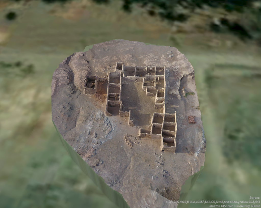
I was able to spend an entire day in Attab East documenting an extremely interesting, and remarkably well-preserved Islamic house, located just south of the Nile. The structure was identified and recorded by André Vila as site 2-S-57, a fortified Islamic house. It was built on a small raised rocky plateau, east of a small drainage channel.

The house is especially interesting in that many of its walls are still very well preserved, along with evidence of a second story, multiple small staircases, and a larger staircase in the northwestern corner of the house, leading to a tower-like structure. Several walls have also collapsed in recent years, and the collapsed building material remains in situ in the southeastern corner of the structure.
The house itself is designed with a large central courtyard surrounded by relatively small interior rooms. These rooms are all roughly rectangular in shape, seem to be similar sizes, and are mostly oriented east to west. Some rooms contain interior sub-divisions, as well as windows and doorways preserved along the northern exterior wall. The rooms form a cellular pattern around the central courtyard, a common architectural pattern in Islamic houses (Abu-Lughod 1987; Petruccioli 2008; Zolfagharkhani and Ostwald 2021). It would certainly be interesting to consider the use of domestic space in this house, as activity areas and movement patterns are surely present.
Current challenges exist to the house’s preservation, including erosion, flooding, and modern use of the house’s rooms as animal pens. It is interesting that there is continuity in the use of this structure for subsistence activities. However, it is extremely important to have the opportunity to digitally document well-preserved, at-risk sites such as this one. I collected approximately 700 images using our Phantom 4 drone of the site and processed a 3D model in Drone2Map.
Given the high-quality model, the site can be virtually “visited” on open-access sites like Sketchfab. This gives diverse publics the opportunity to engage with and experience the site. Furthermore, systematic analyses such as space syntax can be conducted to further understand the use of the site with the data from the model. Digital representations of archaeological sites are especially valuable during periods of political turmoil when cultural heritage may come under threat. Given the on-going conflict and humanitarian crisis in Sudan, and the enduring impact of the Covid 19 pandemic on research disciplines in general, archaeologists must continue to develop innovative solutions to critical problems of cultural heritage management and preservation.
Check out the model of the Islamic house for yourself on MUAFS’s Sketchfab profile:
Here you can play with the model, manipulate the view, zoom in on rooms and features, and experiment with the size of the model. Sketchfab is a completely free educational platform for all users. Be on the lookout for more models from the project in the future!
References:
Abu-Lughod, J.L. (1987). “The Islamic City–Historic Myth, Islamic essence, and Contemporary Relevance”, International Journal of Middle East Studies, 19(2), pp. 155-176.
Petruccioli, A. (2008). “House and Fabric in the Islamic Mediterranean City” in S.K. Jayyusi, R. Holod, A. Petruccioli, and A. Raymond (eds.), The City in the Islamic World: Volume 1. Leiden: Brill: pp. 851-876.
Zolfagharkhani, M. and Ostwald, M.J. (2021). “The Spatial Structure of Yazd Courtyard Houses: A Space Syntax Analysis of the Topological Characteristics of the Courtyard”, Buildings, 11(262), pp. 1-22.
