Today is
the day – after months of preparation, my new ERC project DiverseNile is now
officially running under the grant agreement No. 865463! Many thanks go here
first to all the officers in Brussels and the persons here at LMU who made this
possible, even in challenging times like we are all experiencing in the last
weeks. And of course I am very grateful to my core team who supported the application
and without whom this project would not take place!
More information about the main hypothesis and the objectives of the project are now available here. We are still in the process of recruitment and due to the corona crisis this process will take longer than we thought. Nevertheless, for now we can start working at home collecting and processing data which will enable us to challenge the present categories of “New Kingdom”, “Egyptian”, “Nubian” and “Kerma”. Five exciting years have just started!
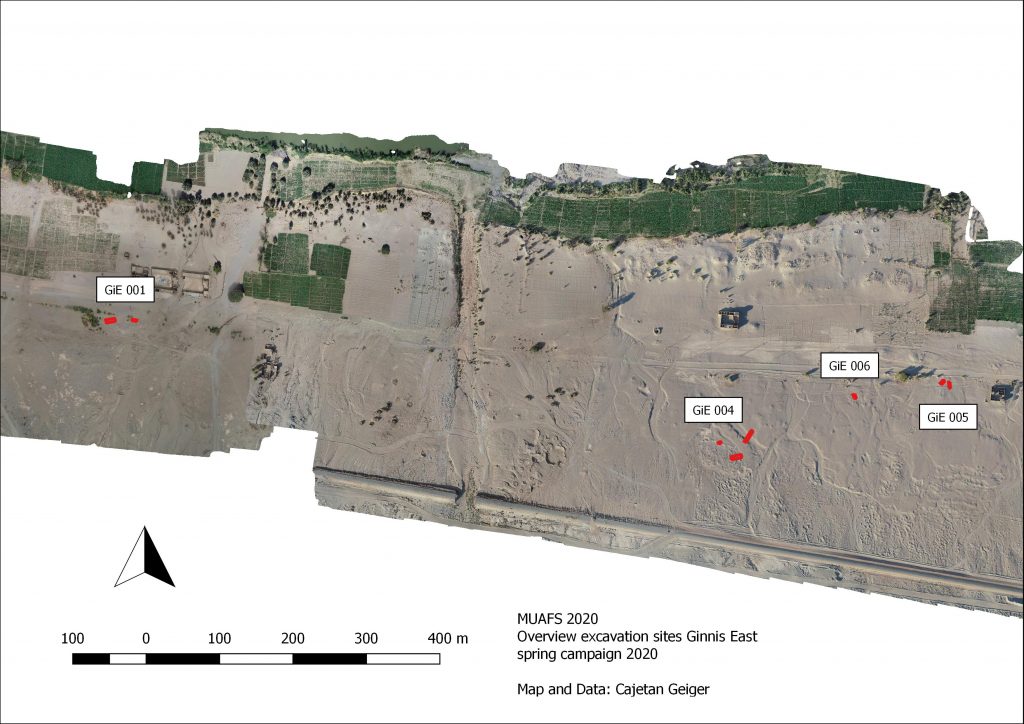
As already reported, the 2020 test excavations of the MUAFS project focused on Bronze Age sites at Ginis East, including Gie 001, where much Egyptian New Kingdom material was found. The following is a very short summary of our work at the Kerma sites GiE 004, 005 and 006.
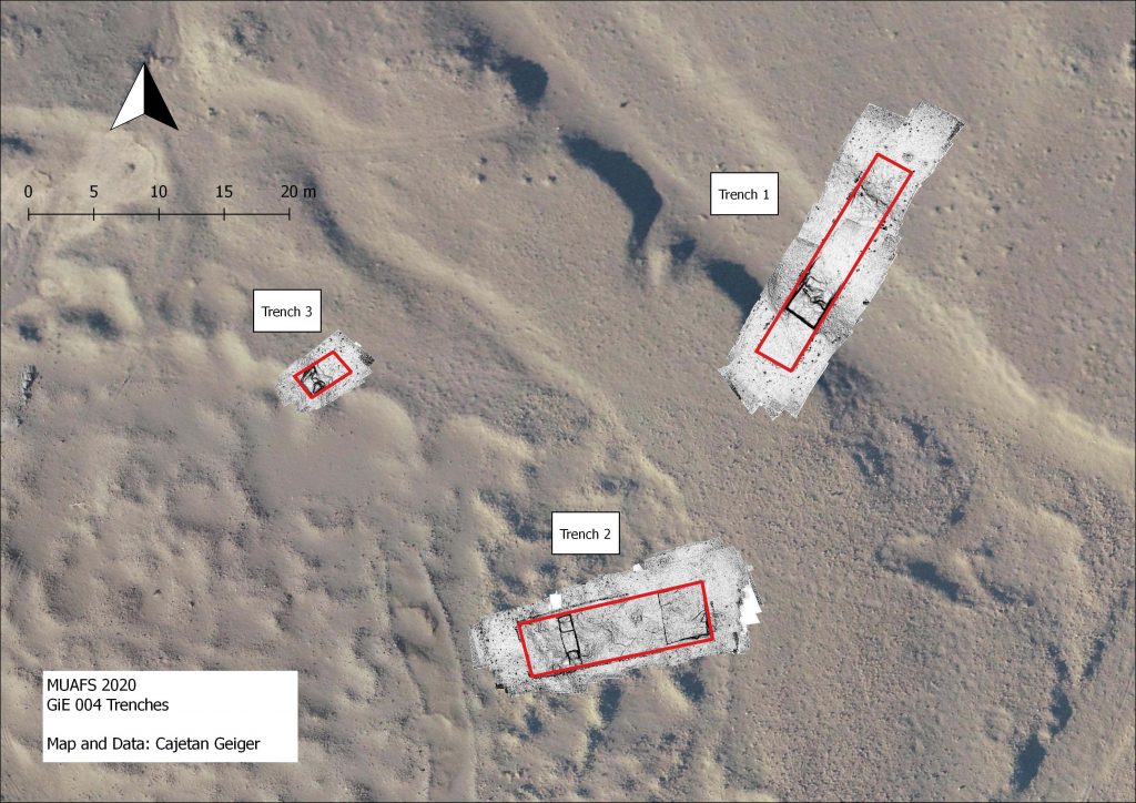
GiE 004
In 2019, we assumed
that the site GiE 004 was documented by Andrè Vila in the 1970s as site 2-T-5.
However, new georeferenced data and fresh GPS waypoints made it clear that this
needs to be corrected and that GiE 004 was not documented by Vila, being
located further to the south than 2-T-5.
The magnetometry survey of the site by MUAFS in 2019 yielded promising results which, according to the finds and the structures visible on the magnetogram, were interpreted as remains of a Kerma village. Rounded huts, fences and walls seemed to be visible. The borders of the wadi systems were also clearly visible in the magnetogram. Our 2020 test trenches were chosen to proof if there was a kind of fortification along the wadi and whether the interpretation of the anomalies were correct.
Three trenches were laid out (Trench 1: 18 x 3 m, at
the edge of a wadi; Trench 2: 14 x 4 m, at the top of the plateau of the site;
Trench 3: 2 x 3.5 m, within a circular depression around the central part of
the site). After a shallow, sandy surface layer with many finds, no
sedimentation and no structures were found in all three trenches. All features
documented and which were alternating areas of sand and clay are clearly
natural. Thus, the clear result of the 2020 text excavation at GiE 004 was that
the anomalies of the magnetometry were over interpreted as structures and are
actually natural features.
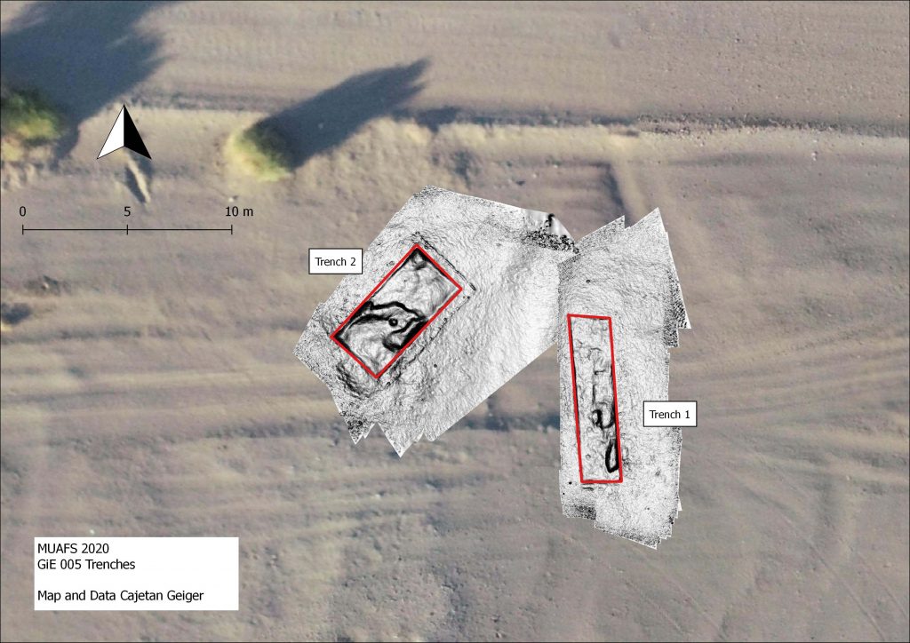
GiE 005 (Vila 2-T-5)
The Kerma site documented by Vila as 2-T-5 was labelled by MUAFS as GIE 005. The site is situated on the alluvial plain, and extends east west on the remains of a shallow, barely visible terrace (25-40 cm high). The site covered in the 1970s an area of c. 500 EW x 35 m NS – part of this is now below modern houses or destroyed because of car tracks. Two test trenches were laid out in 2020 in the eastern part of GIE 005.
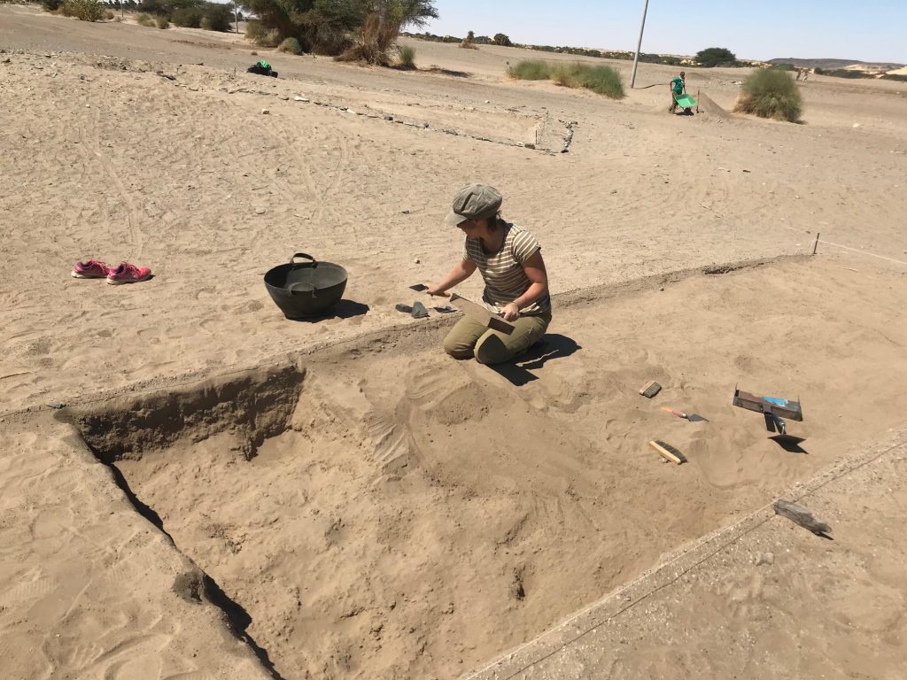
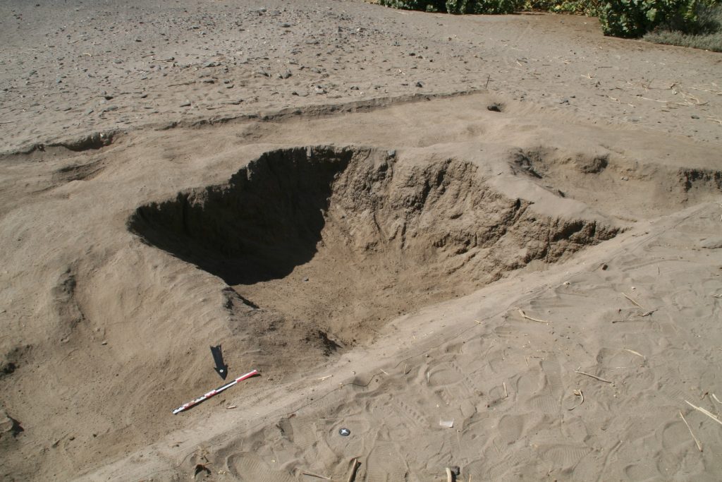
Trench 1 (8 x 2 m) yielded some small depressions and pits below a shallow sandy surface. Very few Kerma sherds were discovered in a lower muddy level, without evidence of structures or stratigraphy.
Work in progress at Trench 1.
Trench 2 (6 x 3 m) comprised a small sandy hill with many schist stones scattered around. Here again, no structures and no sedimentation or stratigraphy were observed. The sandy hill seems to be a sub-recent assemblage of wind-blown sand. Interestingly, the same muddy layer like in Trench 1 below the sand yielded one single artefact, a Kerma sherd laying on a solid clay surface.
Overall, the camp site 2-T-5 is badly preserved, and no stratification is present, as already observed by Vila. One important result of our work in 2020, however, is a tentative dating to the Kerma Classique period and the presence of 18th Dynasty Egyptian material which has not been noted before. There were some Egyptian wheel-made pottery sherds between the ceramics – nicely datable to the early New Kingdom!
GiE 006 (south of Vila 2-T-5)
Surface finds suggest that the camp site 2-T-5 might also extend further to the south, south of the barely visible terrace of GiE 005. In order to test this, a trench was opened at a site now labelled as GIE 006. Trench 1 (3 x 5 m) only yielded surface finds and showed an irregular muddy, natural surface below the sandy surface layer. As in GiE 005, no stratification is preserved.
Cleaning the surface at GiE 006.
Although the finds are mixed and can also be explained with a multi-period use of the site, most of the material belongs to the Kerma horizon. Thus, this is probably an extension of a Kerma camp identical or similar to GiE 005.
Summary
In sum, the test
excavations at Ginis East – including the results from GIE 001, provided
important new data on 1) the character of the sites, 2) the dating of the sites
and 3) the clarification that the interpretation of the magnetometry survey
from 2019 turned out to show no actual structures, but different natural layers
at GiE 001 and GiE 004.
As it was already observed by Vila, at many sites on the east bank in the MUAFS concession there is little or no sedimentation preserved. This is an important aspect to consider in our next field seasons – the situation is markedly different on the west bank where we also documented some intriguing Bronze Age sites with mud brick remains. There is still much work ahead of us!
The world has changed since last week – COVID-19 has a major influence on archaeological fieldwork, universities and museums. MUAFS was very lucky in this respect – after our odyssey with the extra day in Khartoum and a night in Istanbul, we made it safely to Munich, just in time before borders got closed and flights cancelled. Of course all planned fieldwork in Egypt in April had to be cancelled and I could also not make my home visit to Vienna. But difficult times require flexibility and the most important thing now is of course to flatten the curve and to stay safe (and home)!
Well –
research for MUAFS is of course still possible and all of us are using the time
in home office for reading things and compiling the data from the 2020 season.
The following is just a short summary of our test excavations of the 2020 season – this season was a preparation season for the next, longer field season which will be the start of my new European Research Council Project DiverseNile. Thus, the focus was on promising sites dating to the Bronze Age/Kerma Period in the Ginis East area where also Egyptian presence of the New Kingdom is attested.
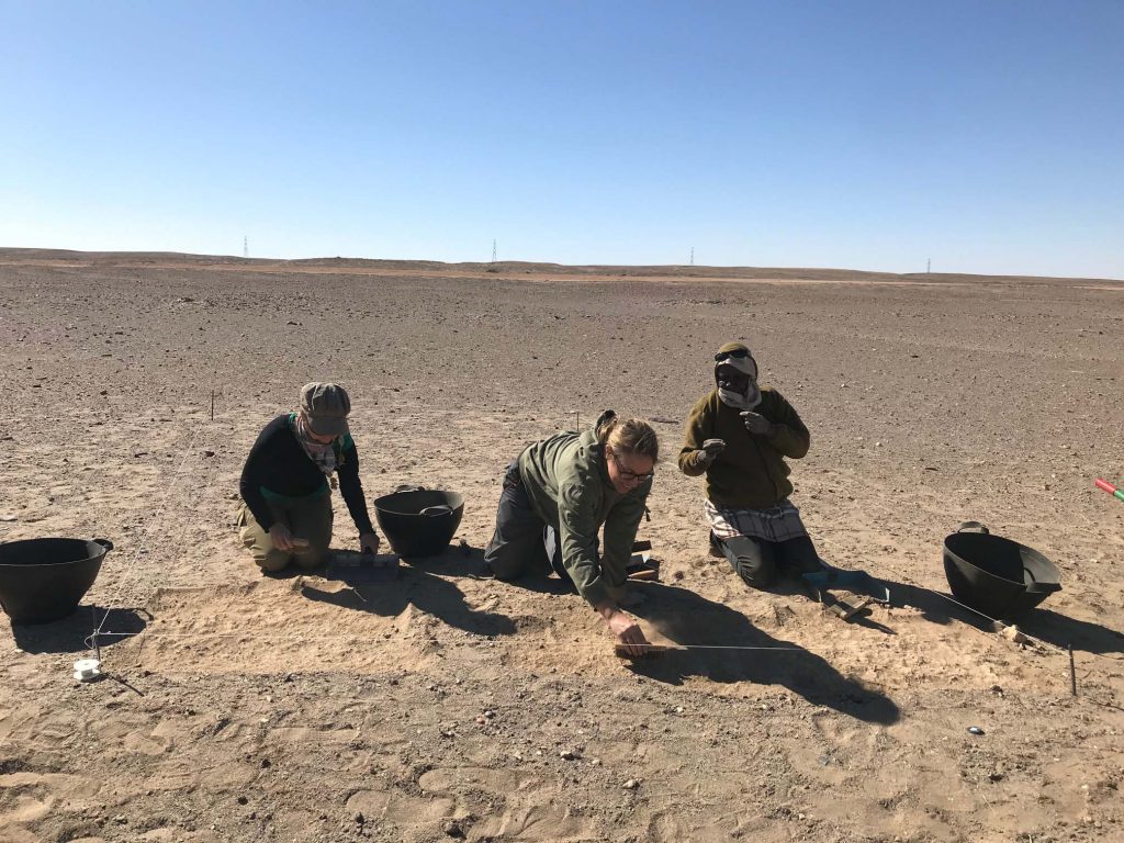
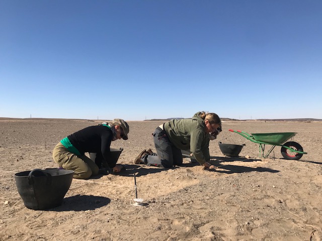
In order to get familiar with the site formation processes and sedimentation in the area, we conducted at four sites in the district of Ginis East small test excavations. A total of 8 trenches were excavated by the team; local workmen will be engaged in the next season.
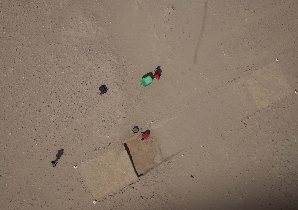
Location of sites and test trenches at Ginis East 2020.
As you will see in the following – the results from the individual sites were not as we hoped for but are nevertheless very important outcomes of what was designed as a test season.
I will start with site GIE 001 and a separate post will present the results from the other sites at Ginis East.
GiE 001 – a New Kingdom (and Kerma?) settlement site
Recorded by Vila
as 2-T-36B, this domestic site at Ginis East can be assigned to the Egyptian
New Kingdom, showing also an intriguing Kerma presence according to the surface
finds. Magnetometry was conducted by MUAFS in 2019. In the 2020 season, two
trenches were laid out above promising anomalies in the magnetometry in the
northeastern part of the site.
Trench 1 (6 x 4
m) yielded, apart from surface finds which were mixed and dated from the Kerma
Period, the New Kingdom, the Napatan Period and Christian times, some Kerma
Classique sherds from lower levels. However, no structures were found and the
magnetometry seems to show natural features, especially more sandy areas which
contrast to clay layers/alluvial sediments.
Trench 2 (10 x 4 m) generated large quantities of ceramics and stone tools from the surface. The main archaeological features found in this trench were sub-recent pits deriving from marog activities. The largest of these pits in Trench 2, Feature 1, is 2.40 m in diameter and 75 cm deep. It was filled with fine sand and the traces of the tools the marog diggers used are clearly visible on the sloping edges. We documented everything in 3D according to our standard procedure. The find material comprised mostly mixed pottery from the New Kingdom, Napatan and Medieval era as well as some recent date seeds and small pieces of charcoal and bone.
Feature 1, the marog pit, in Trench 2 at GIE 001.
Both trenches in GiE 001 did not yield mud bricks or
any structures from the New Kingdom; it is likely that this part with the
trenches is already located outside of the former settlement area. That the
area was inhabited and used during both the 18th Dynasty and the
Ramesside period, becomes nevertheless evident from the find assemblages we
collected.
Excavation and processing of data at GIE 001 will continue, but for now the New Kingdom site with later use seems associated with gold exploitation in the periphery of Sai Island and Amara West, as I have already proposed in an earlier post based on the finds (ceramics and stone tools).
We finished
our test trenches and surface documentation at the Ginis East Kerma/New Kingdom
sites yesterday. The last 6 working days until our departure to Khartoum will
be dedicated to a foot survey – like last year, we will check the sites
recorded by Vila and whether there are more findings, additional sites or other
changes.
But back to
the test trenches and our results from site GiE 004 where we documented in
total 5 test areas. 3 were excavated, in 2 we only cleaned the surface and
checked the find distribution/density.
I will deal with the relation between our results and the magnetometry from 2019 in another “Lessons learned from the 2020 season” blog post in the next days – for today, I’d like to share some news about the finds from GiE 004.
Initially,
we thought that it is a Kerma site with a long occupation. This was partly
confirmed and interestingly, Kerma Classique material dominants the ceramics!
But more important, especially for our investigations of “cultural markers”, is
that 18th Dynasty, Egyptian New Kingdom pottery is also present,
including imported Canaanite amphora and very few Marl clay sherds. A quite
unexpected result, which gives us much food for thought!
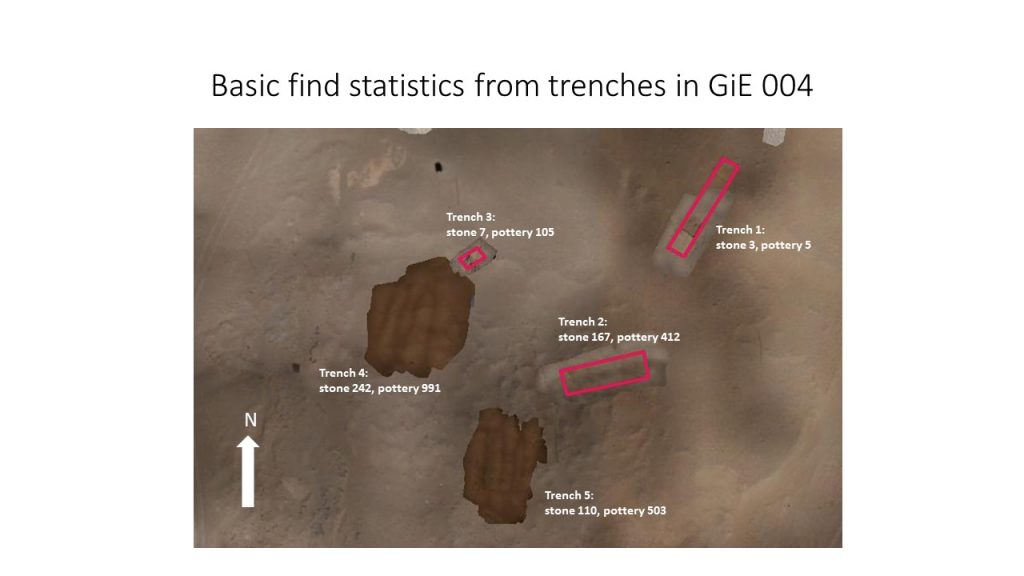
But let’s
look at some basic numbers of finds – of course you have to keep in mind the
differing sizes of our test trenches, but the quantities of stone tools and
pottery are quite significant:
Trench 1 –
stone 3, pottery 5
Trench 2 –
stone 167, pottery 412
Trench 3 –
stone 7, pottery 105
Trench 4 –
stone 242, pottery 991
Trench 5 – stone 110, pottery 503
These numbers support the interpretation that Trench 1 and 3 are located at the edges or even outside the actual site; Trenches 2, 4 and 5 are very similar and all yielded much Kerma Classique material as well as Egyptian wheel-made pottery of the New Kingdom. The majority comes here from Trench 4 where almost 50% of the pottery from GiE 004 was found.
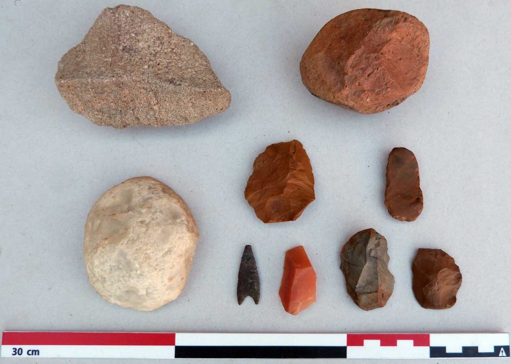
Trench 4 also yielded very nice stone tools, including a wonderful small arrowhead.
Overall,
although much of the surface material in these trenches from GiE 004 was
wind-worn and eroded as well as mixed (of course, there were also Medieval
pieces present), both the pottery and lithics/stone tools speak for a domestic
character of the site with different activity zones.
Since today
is a study day in the digging house to work on the finds from week 1 and 2, especially
pottery and lithics, I also have some time to give an update on our activities.
We concentrated on 3 sites in the area of Ginis East – all of them date back to the Kerma period, but especially at GiE 004 and GiE 005 there was also later activity based on surface finds and Christian ceramics.
We only laid out test trenches this season since we wanted to check the common status of sedimentation and stratigraphy. And this turned out as quite disappointing – no stratigraphy was preserved in most cases, although two trenches yielded a few pottery sherds from a quite deep level. For all trenches, we used the same imaged based documentation system that we developed over the last years at Sai Island and it was very valuable to practice it in these new surroundings.
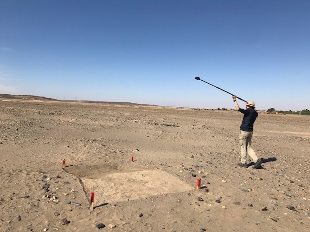
In addition, we got some very nice kite aerial photos from the sites.
Well, we will collect and analyse all these data further and despite of all, these are of course useful information for the general understanding of our concession area and the individual sites.
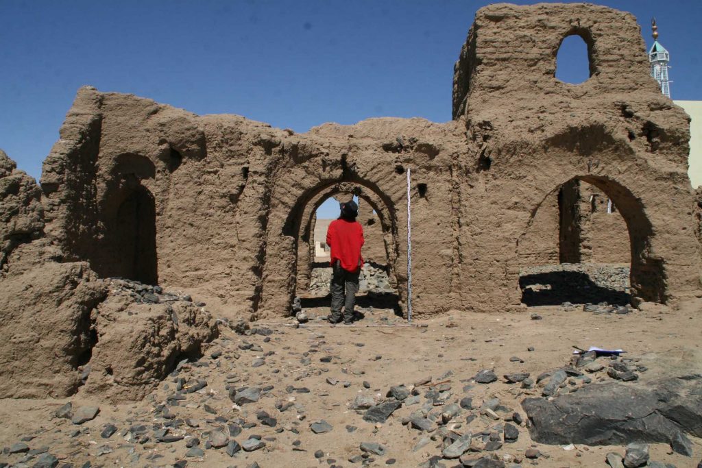
Another task this week was the small mud brick church at Mograkka (Vila site 3-L-2). Cajetan, Jessica and Huda spent an intense day there and re-mapped it. Our documentation includes a 3D structure from motion digital photographic documentation in combination with survey points from a total station. This is the first working step within a planned excavation and site management plan for this monument in the near future.
In the coming days, we will continue with test trenches at sites in Ginis East. This time with a very promising site where the surface is covered with loads of pottery from the Kerma period, the Egyptian New Kingdom and Napatan times. Keep your fingers crossed that there is some stratigraphy preserved!
Our second
MUAFS season started very promising and successful – we arrived as planned last
Wednesday in Ginis East and moved into a beautiful house we have rented for
this season.
On
Thursday, we set out our test trenches at the site of Ginis East 004, a Kerma
camp which was already recorded by Vila in the 1970s and where we made a magnetometer
survey last year.
The aim for this season is to check the stratigraphy of the site and especially to test whether the results of the magnetometry correspond to the actual archaeology.
The general site of GiE 004, a Kerma village.
Three test trenches were laid out on Thursday and I started already surface cleaning in Trench 1 while the rest of the team was busy mapping and taking survey points. And here some of our problems started – our total station sent error messages and a big drawback was when we discovered on Friday that some of our benchmarks we set last year have been destroyed and are no longer usable… And our printer did not work anymore… To make things worse, I caught a food poisoning and had to go to the clinic in Abri for treatment. Thus, fieldwork at GiE 004 was stopped for the last 2 days. We hope to continue this afternoon since after hours and hours Cajetan seems to have solved the problem with the total station and I am more or less recovered.
Well – sometimes life as an archaeologist is really like a box of chocolate, full of surprises and not always of the sweet kind. As difficult as it is, we will try to stick with our schedule – hoping that we are now done with all the major problems of this season!
News about
proper fieldwork will therefore hopefully follow shortly…
We safely arrived in Khartoum Sunday night and we were really lucky this time, as we just left Munich before storm “Sabine” caused big problems for flights and other transportation. In the last two days here in Sudan, we were busy preparing everything for the second MUAFS seasons.
Quite a number of things have changed with the new government, with new regulations – there are still some pending Tasks for tonight but all in all, everything went well and we can stick to our time schedule and leave Khartoum tomorrow morning as planned.
Many thanks
go already to the National Corporation for Antiquities and Museums (NCAM) in
Sudan for all their support. Our NCAM inspector will be again our dear old
friend and colleague, Huda Magzoub, who worked with us already in the first
MUAFS season.
Looking very much forward to our travel to the beautiful area of northern Sudan and starting fieldwork in Ginis at a Kerma settlement site on Thursday! Given that our mobile connection allows it, we will of course keep you updated about our progress.
Time flies by, the winter term at LMU is in its final stage with exams approaching – and thus the next field season in the Attab to Ferka region in northern Sudan is getting closer.
We will work 4 weeks in February/March with new headquarters in Ginis East, where there are multiple Bronze Age sites and a stunning landscape.
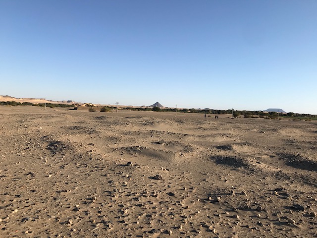
Landscape at Ginis East, looking northwest.
Today, we had a team meeting in the office, discussing the main aims and logistics for this season. As kind of prelude for the new ERC project DiverseNile, we will test a very promising Kerma site at Ginis East.
The principal goal of our first season is a test excavation at the site GiE 004. This site was documented by Andrè Vila in the 1970s (as site NF-36-M/2-T-5) and his work included some test trenches. We made a successful magneometry survey of this very intriguing Kerma village in 2019 and would now like to check the validity of our own results (created by Marion Scheiblecker). This Kerma settlement system comprises rounded huts and additional walls or fences; the southern part of the site, consisting of Kerma graves, is very recently destroyed. Rectangular as well as circular features are visible in the northern part of the investigated area showing negative magnetic anomalies. They could be caused by mudbrick with less magnetisable content than in the southern part, where the magnetic anomalies show high positive values indicating different building materials and/or sources. The borders of the wadi systems are clearly visible in the magnetogram of GiE 004; an excavation could proof if there was a kind of fortification along the wadi. This is the main aim for the 2020 excavation season.
Looking
much forward to our first season of excavation in the MUAFS concession – and of
course we will keep you posted!
The last months were really busy with work in Egypt and administrative tasks in Munich. Although the teaching term is ongoing and preparing classes keeps me occupied, there is also some time to process the data we collected in December and January between Attab and Ferka.
The annual one-day international colloquium on “Recent Archaeological Fieldwork in Sudan” at the British Museum London is approaching – and I am delighted that I will have the chance to talk about the most important results from our first field season.
I will try to summarise the distribution of the Vila sites we re-located and discuss some aspects of their dating and cultural classification.
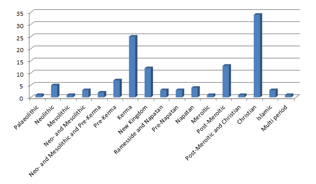
Within the 119 sites we documented, the majority are Christian sites (28,6%). Kerma sites are with 21% also very numerous. The strong presence of Late Bronze Age/Iron Age (New Kingdom, Pre-Napatan and Napatan) sites is with 18,5% also noteworthy. Especially in the northern part of our concession, large tumuli cemetery from the Post-Meroitic period were noted and Post-Meroitic sites comprise 11,8% of our total. The early periods, in particular Abkan and Khartoum Variant sites, are also well presented in the MUAFS concession area (Neo- and Mesolithic sites with 9,2%).
Looking much forward to process these data further until next Monday and in particular to meet all the colleagues working in Sudan on this occasion in London – for scientific and social updates!
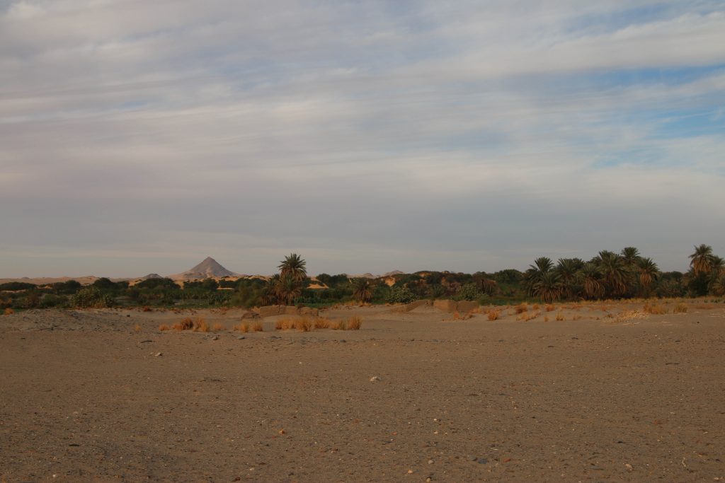
From the Nile back to the Isar, from sun and sand back to clouds and snow, from desert walking back to desk work, emails, meetings and teaching – although our travel back from Attab via Khartoum via Istanbul to Munich took more than 30 hours, it feels like a very sudden transposition.
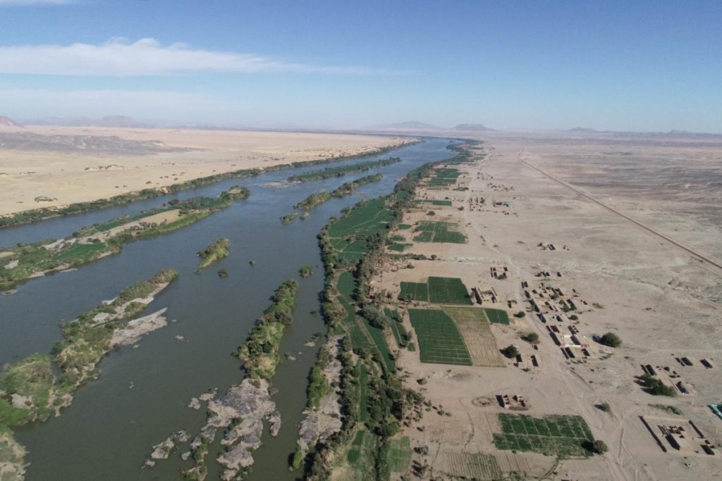
Landscape view of our concession area in northern Sudan.
Our first season of the MUAFS project was successfully closed and all of the principle goals were achieved thanks to the great support of NCAM and our inspector Huda Magzoub.
The principal goal of the first season was a new survey of the concession area, which was already recorded by Andrè Vila in the 1970s and published in his volumes 3-6. Altogether, 119 sites by Vila were re-identified and documented in the area between Attab East and Ferka East and Attab West and Mograkka West. For some of these sites, the dating can now be corrected, especially for Khartoum Variant and Abkan sites, Pre-Kerma sites, Kerma, New Kingdom and Napatan sites. Diagnostic stone tools and pottery fragments were collected from relevant sites. Other findspots of pottery and lithics that were previously not recorded by Vila, were documented as GPS waypoints and will be integrated in the new map of the area to be composed based on the results of our first season.
One particular focus was on the state of preservation of the sites
nowadays – unfortunately, at almost all sites, we observed modern destruction
and/or plundering. Especially drastic were destructions because of road
building, the electricity posts and modern gold working areas (in particular at
Mograkka West).
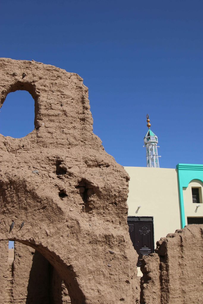
Major changes were observed compared to the state of preservation in times of Vila – one particularly illustrative example is Vila’s Kerma Period site 2-T-36B, partly overbuilt by modern houses and reduced because of the new electricity posts. Another example from the well-attested Christian period in our concession area is the church of Mograkka (2-L-2). While Vila documented it as single monument on a small hilltop, it is now embedded in newly built modern houses of the expanding village. The church new next-door neighbor is a modern mosque erected in the last years. Unfortunately, most of the Christian rock art, located by Vila in the immediate surroundings, are presently covered by modern debris from recent chanel works.
Detail of the well-preserved Church at Mograkka East with its new neighbour.
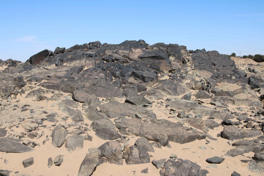
At other places, especially between Mograkka and Kosha, Neolithic and Post-Meroitic as well as Christian rock art was relocated by us. The most frequent motifs are cattle pictures and other animals like gazelles, hippos, ostriches and elephants.
Rock art site at Mograkka West.
The focus of our work in the first season was the east bank and here in
particular the district of Ginis. We conducted aerial photography of large
parts of the east bank, covering the area between Attab and Ginis by the drone
kindly lent to us from the Department of Cultural and Ancient Studies of LMU
Munich. These data will enable a digital elevation model and detailed
orthophotos. A survey system with measuring points using the GPS Antenna was
set up in this area as well, securing future work according to this
coordination.
A geophysical survey of four sites from the Kerma period and the New Kingdom was realized by Marion Scheiblecker in Ginis East, using the Magnetometer of the type Ferex Foerster. New site labels were created for these find spots (GiE 001 for Vila 2-T-36B: Kerma and New Kingdom settlement, GiE 002 for Vila 2-T-13: New Kingdom cemetery, GiE 003 for Vila 2-T-39: Kerma cemetery and GiE 004 for Vila 2-T-5: Kerma settlement). The respective results are very promising and can serve as firm basis for a focused excavation of these important sites in the upcoming seasons.
In sum, the first season of the MUAFS project was very successful, providing new and partly unexpected results (like the strong presence of Napatan sites in the region), highlightening the rich potential of the concession area for detailed work from the Mesolithic period up to Christian times and allowing us to plan the next working steps. For now, we consider the Kerma and New Kingdom sites already investigated by magnetometry as of prime priority for further fieldwork.
We will be busy in the next week working on the collected data from our field season and setting up a strategy for the next years of work between Attab and Ferka. Of course we will keep you updated!